Sheldon, New York

Last updated

Sheldon, New York
Wyoming County NY Sheldon town highlighted.svg
Location within Wyoming County and New York
USA New York location map.svg
Red pog.svg
Sheldon, New York
Location within the state of New York
Coordinates: 42°43′36″N78°22′27″W / 42.72667°N 78.37417°W / 42.72667; -78.37417
Country United States
State New York
County Wyoming
Area
[1]
  Total47.37 sq mi (122.70 km2)
  Land47.35 sq mi (122.63 km2)
  Water0.03 sq mi (0.07 km2)
Elevation
1,490 ft (454 m)
Population
 (2010)
  Total2,409
  Estimate 
(2016) [2]
2,317
  Density48.94/sq mi (18.89/km2)
Time zone UTC-5 (Eastern (EST))
  Summer (DST) UTC-4 (EDT)
ZIP code
14145
Area code 585
FIPS code 36-66773
GNIS feature ID0979488
Website www.townofsheldon.com

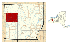
Sheldon is an incorporated town in Wyoming County, New York. The population was 2,409 at the 2010 census. The Town of Sheldon is on the west border of Wyoming County. The town is southeast of Buffalo.

Contents

History

The Town of Sheldon was founded in 1808 from part of the Town of Batavia. In 1811, the Town of Attica was formed from part of Sheldon, and the Towns of Bennington and Arcade were taken off in 1818.

Geography

According to the United States Census Bureau, the town has a total area of 47.4 square miles (123 km2), of which 47.3 square miles (123 km2) is land and 0.04 square miles (0.10 km2) (0.06%) is water.

The west town line is the border of Erie County, New York. Cayuga Creek flows northward through the east part of the town and the Buffalo Creek flows through the southwest part.

U.S. Route 20A passes across the north part of the town and intersects New York State Route 77 at Persons Corners.

Demographics

Historical population
CensusPop.Note
1820 887
1830 1,73195.2%
1840 2,35335.9%
1850 2,5277.4%
1860 2,79410.6%
1870 2,258−19.2%
1880 2,2570.0%
1890 2,059−8.8%
1900 1,801−12.5%
1910 1,713−4.9%
1920 1,593−7.0%
1930 1,545−3.0%
1940 1,5782.1%
1950 1,6182.5%
1960 1,89817.3%
1970 2,29621.0%
1980 2,64415.2%
1990 2,487−5.9%
2000 2,5613.0%
2010 2,409−5.9%
2016 (est.)2,317 [2] −3.8%
U.S. Decennial Census [3]

As of the census [4] of 2000, there were 2,561 people, 916 households, and 707 families residing in the town. The population density was 54.1 inhabitants per square mile (20.9/km2). There were 973 housing units at an average density of 20.6 per square mile (7.9/km2). The racial makeup of the town was 99.61% White, 0.04% African American, 0.04% Asian, 0.04% Pacific Islander, 0.16% from other races, and 0.12% from two or more races. Hispanic or Latino of any race were 0.23% of the population.

There were 916 households, out of which 35.0% had children under the age of 18 living with them, 65.5% were married couples living together, 7.3% had a female householder with no husband present, and 22.8% were non-families. 18.2% of all households were made up of individuals, and 7.9% had someone living alone who was 65 years of age or older. The average household size was 2.79 and the average family size was 3.20.

In the town, the population was spread out, with 27.0% under the age of 18, 8.3% from 18 to 24, 29.8% from 25 to 44, 22.5% from 45 to 64, and 12.5% who were 65 years of age or older. The median age was 36 years. For every 100 females, there were 104.2 males. For every 100 females age 18 and over, there were 102.4 males.

The median income for a household in the town was $43,232, and the median income for a family was $45,701. Males had a median income of $32,319 versus $21,549 for females. The per capita income for the town was $18,698. About 5.2% of families and 5.8% of the population were below the poverty line, including 9.4% of those under age 18 and 3.1% of those age 65 or over.

Notable people

Communities and locations in Sheldon

Related Research Articles

Ashford is a town in Cattaraugus County, New York, United States. The population was 1,974 at the 2020 census. The town is on the county's northern border.

<span class="mw-page-title-main">Dayton, New York</span> Town in New York, United States

Dayton is a town in Cattaraugus County, New York, United States. The population was 1,689 at the 2020 census. The town is on the western border of Cattaraugus County.

<span class="mw-page-title-main">Villenova, New York</span> Town in New York, United States

Villenova is a town in Chautauqua County, New York, United States. The population was 1,053 at the 2020 census. The town is on the eastern border of the county and is southeast of Dunkirk.

<span class="mw-page-title-main">Cuyler, New York</span> Town in New York, United States

Cuyler is a town in Cortland County, New York, United States. The population was 908 at the 2020 census.

<span class="mw-page-title-main">Darien, New York</span> Town in Genesee County, New York

Darien is a town in Genesee County, New York, United States. The population was 3,010 at the 2020 census. Darien lies in the southwestern part of Genesee County, southwest of Batavia.

Pamelia is a town in Jefferson County, New York, United States. The population was 3,160 at the 2010 census, up from 2,897 in 2000. The town was named for Pamelia Williams, wife of landowner and developer General Jacob J. Brown.

<span class="mw-page-title-main">Royalton, New York</span> Town in New York, United States

Royalton is a town in Niagara County, New York, United States. The population was 7,660 at the 2010 census.

<span class="mw-page-title-main">Vienna, New York</span> Town in New York, United States

Vienna is a town in Oneida County, New York, United States. The population was 5,440 at the 2010 census. The town is named after the capital of Austria.

Bristol is a town in Ontario County, New York, United States. The population was 2,298 at the 2020 census. Bristol was named after Bristol County, Massachusetts, by settlers from New England. The town of Bristol is in the western half of the county, southwest of the city of Canandaigua.

<span class="mw-page-title-main">Murray, New York</span> Town in Orleans County, New York

Murray is a town in Orleans County, New York, United States. The population was 6,259 at the 2000 census.

<span class="mw-page-title-main">Covington, New York</span> Town in New York, United States

Covington is an incorporated town in Wyoming County, New York. The population was 1,231 at the 2010 census. The town was named after General Leonard Covington.

<span class="mw-page-title-main">Java, New York</span> Town in New York, United States

Java is an incorporated town in Wyoming County, New York. The population was 2,057 at the 2010 census. The Town of Java is on the western border of Wyoming County.

<span class="mw-page-title-main">Orangeville, New York</span> Town in New York, United States

Orangeville is an incorporated town in Wyoming County, New York. The population was 1,301 at the 2000 census.

<span class="mw-page-title-main">Wethersfield, New York</span> Town in New York, United States

Wethersfield is an incorporated town in Wyoming County, New York. The population was 891 at the time of the 2000 census. The Town of Wethersfield is centrally located in the county.

<span class="mw-page-title-main">Peru, New York</span> Town in New York, United States

Peru is a town in Clinton County in the U.S. state of New York. The population was 6,772 at the 2020 census. The town was so named for its views of the Adirondack Mountains to the west and the farmlands throughout the town, resembling scenery found in the country of Peru in South America. Peru, New York, is in the southeastern part of Clinton County, south of Plattsburgh.

Leicester is a town in Livingston County, New York, United States. The population was 2,200 at the 2010 census. The town is named after Leicester Phelps, an early inhabitant.

Livonia is a town in Livingston County, New York, United States. As of the 2010 census, the town population was 7,809. The town contains a village also named Livonia. The town is on the eastern border of the county.

<span class="mw-page-title-main">Perry, New York</span> Town in New York, USA

Perry is a town in Wyoming County, New York, United States. The population was 5,813 at the 2020 census. The town is named after Commodore Oliver Hazard Perry.

<span class="mw-page-title-main">Warsaw, New York</span> Town in New York, United States

Warsaw is a town in Wyoming County, in the U.S. state of New York. The population was 5,316 at the 2020 census. It is located approximately 37 miles east southeast of Buffalo and approximately 37 miles southwest of Rochester. The town may have been named after Warsaw, Poland.

<span class="mw-page-title-main">Newfane, New York</span> Town in New York, United States

Newfane is a town in Niagara County, New York, United States. The population was 9,666 at the 2010 census.

References

  1. "2016 U.S. Gazetteer Files". United States Census Bureau. Retrieved July 5, 2017.
  2. 1 2 "Population and Housing Unit Estimates" . Retrieved June 9, 2017.
  3. "Census of Population and Housing". Census.gov. Retrieved June 4, 2015.
  4. "U.S. Census website". United States Census Bureau . Retrieved January 31, 2008.
  5. "GATES, Seth Merrill, (1800 - 1877)". Biographical Directory of the United States Congress. Retrieved March 19, 2014.
  6. THE LEGISLATIVE MANUAL OF THE STATE OF WISCONSIN (15th ed.). Madison, Wis. 1876. p. 475.{{cite book}}: CS1 maint: location missing publisher (link)
  7. "Lester Hayden Humphrey". Ancestry.com. Retrieved March 19, 2014.
  8. 'Wisconsin Blue Book 1891,' Biographical Sketch of Enos Warren Persons, pg. 577-578
  9. Beers, J.H. and Co. (1906). Commemorative Biographical Record of Prominent and Representative Men of Racine and Kenosha Counties, Wisconsin: Containing Biographical Sketches of Business and Professional Men and of Many of the Early Settled Families. J.H. Beers & Company. p. 69.


42°44′14″N78°25′07″W / 42.73722°N 78.41861°W / 42.73722; -78.41861