Gainesville (village), New York

Last updated
Gainesville, New York
USA New York location map.svg
Red pog.svg
Gainesville, New York
Location within the state of New York
Coordinates: 42°39′51″N78°6′58″W / 42.66417°N 78.11611°W / 42.66417; -78.11611 Coordinates: 42°39′51″N78°6′58″W / 42.66417°N 78.11611°W / 42.66417; -78.11611
Country United States
State New York
County Wyoming
Settled1805 (1805)
Incorporated1902 (1902)
Named for Edmund P. Gaines
Area
[1]
  Total0.86 sq mi (2.22 km2)
  Land0.86 sq mi (2.22 km2)
  Water0.00 sq mi (0.00 km2)
Elevation
1,663 ft (507 m)
Population
 (2020)
  Total211
  Density246.50/sq mi (95.18/km2)
Time zone UTC-5 (Eastern (EST))
  Summer (DST) UTC-4 (EDT)
ZIP code
14066
Area code 585
FIPS code 36-27969
GNIS feature ID950842
Website www.wyomingco.net/towns/villageofgainesville.htm

Gainesville is a village in Wyoming County, New York, United States. The population was 304 at the 2000 census. The village is named after General Edmund P. Gaines. [2]

Contents

The Village of Gainesville lies within the boundaries of the Town of Gainesville. The village is on NYS Route 19, south of NYS Route 78.

History

The Village of Gainesville was incorporated in 1902.

Geography

According to the United States Census Bureau, the village has a total area of 0.9 square mile (2.2 km2), all land.

Demographics

Historical population
CensusPop.
1910 327
1920 3414.3%
1930 270−20.8%
1940 2834.8%
1950 31411.0%
1960 36917.5%
1970 3854.3%
1980 334−13.2%
1990 3401.8%
2000 304−10.6%
2010 229−24.7%
2020 211−7.9%
U.S. Decennial Census [3]

As of the census of 2000, there were 304 people, 113 households, and 87 families residing in the village. The population density was 356.8 people per square mile (138.1/km2). There were 122 housing units at an average density of 55.4 persons/km2 (143.2 persons/sq mi). The racial makeup of the village was 99.67% White, 0.00% African American, 0.00% Native American, 0.33% Asian, 0.00% Pacific Islander, 0.00% from other races. 0.66% of the population were Hispanic or Latino of any race.

There were 113 households, out of which 44.2% had children under the age of 18 living with them, 53.1% were married couples living together, 15.9% have a woman whose husband does not live with her, and 23.0% were non-families. 16.8% of all households were made up of individuals, and 4.4% had someone living alone who was 65 years of age or older. The average household size was 2.69 and the average family size was 2.98.

In the village, the population was spread out, with 30.6% under the age of 18, 6.9% from 18 to 24, 30.6% from 25 to 44, 21.4% from 45 to 64, and 10.5% who were 65 years of age or older. The median age was 36 years. For every 100 females, there were 104.0 males. For every 100 females age 18 and over, there were 91.8 males.

The median income for a household in the village was $31,875, and the median income for a family was $30,500. Males had a median income of $33,571 versus $18,000 for females. The per capita income for the village was $14,385. 7.4% of the population and 6.1% of families were below the poverty line. Out of the total people living in poverty, 6.7% are under the age of 18 and 0.0% are 65 or older.

Notable people

Related Research Articles

<span class="mw-page-title-main">Vandenberg Village, California</span> Census-designated place in California, United States

Vandenberg Village is a census-designated place (CDP) in the unincorporated area of Santa Barbara County, California, United States. The population was 6,497 at the 2010 census, up from 5,802 at the 2000 census.

<span class="mw-page-title-main">Buckingham, Illinois</span> Village in Illinois, United States

Buckingham is a village in Kankakee County, Illinois, United States. The population was 300 at the 2010 census, up from 237 at the 2000 census. It is included in the Kankakee-Bradley, Illinois Metropolitan Statistical Area.

<span class="mw-page-title-main">Sheridan, Michigan</span> Village in Michigan, United States

Sheridan is a village in Montcalm County in the U.S. state of Michigan. The population was 649 at the 2010 census. The village is located at the corners of four townships and incorporates land from each: Evergreen Township to the northeast, Bushnell Township to the southeast, Fairplain Township to the southwest, and Sidney Township to the northwest.

<span class="mw-page-title-main">Stephen, Minnesota</span> City in Minnesota, United States

Stephen is a city in Marshall County, Minnesota, United States. The population was 592 at the 2020 census.

<span class="mw-page-title-main">Leslie, Missouri</span> Village in Missouri, United States

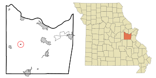
Leslie is a village in west central Franklin County, Missouri, United States. The population was 171 at the 2010 census.

<span class="mw-page-title-main">Gainesville, Missouri</span> City in Missouri, United States

Gainesville is a city in Ozark County, Missouri, United States. The population was 745 at the 2020 census. It is the county seat of Ozark County.

<span class="mw-page-title-main">Penermon, Missouri</span> Village in Missouri, United States

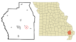
Penermon is a village in Stoddard County, Missouri, United States. The population was 64 at the 2010 census.

<span class="mw-page-title-main">Champ, Missouri</span> Village in Missouri, United States

Champ is a village in St. Louis County, Missouri, United States. The population was 10 at the 2020 census.

<span class="mw-page-title-main">Silver Springs, New York</span> Village in New York, United States

Silver Springs is a village in Wyoming County, New York, United States. The population was 782 at the 2010 census.

<span class="mw-page-title-main">Brookside, Ohio</span> Village in Ohio, United States

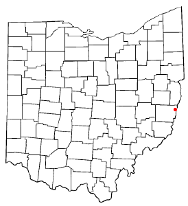
Brookside is a village in Belmont County, Ohio, United States. It is part of the Wheeling, West Virginia Metropolitan Statistical Area. The population was 632 at the 2010 census.

<span class="mw-page-title-main">Lyons, Ohio</span> Village in Ohio, United States

Lyons is a village in Fulton County, Ohio, United States. The population was 562 at the 2010 census.

<span class="mw-page-title-main">Gratis, Ohio</span> Village in Ohio, United States

Gratis is a village in Preble County, Ohio, United States. The population was 881 at the 2010 census. It is part of the Dayton Metropolitan Statistical Area.

<span class="mw-page-title-main">Wilmot, Ohio</span> Village in Ohio, United States

Wilmot is a village in Stark County, Ohio, United States. The population was 304 at the 2010 census. It is part of the Canton–Massillon Metropolitan Statistical Area.

<span class="mw-page-title-main">Morrow, Ohio</span> Village in Ohio, United States

Morrow is a village in Salem Township, Warren County, Ohio, United States. The population was 1,188 at the 2010 census.

<span class="mw-page-title-main">Town of Maine, Wisconsin</span> Town in Wisconsin, United States

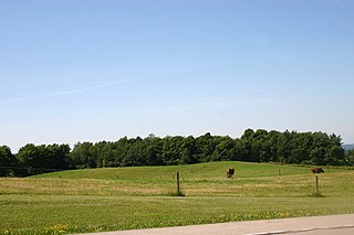
Maine is a town in Outagamie County, Wisconsin, United States. The population was 831 at the 2000 census. The unincorporated community of Leeman is located in the town.

Arcade is a village in Wyoming County, New York. The population was 2,071 at the 2010 census.

<span class="mw-page-title-main">Gainesville (town), New York</span> Town in New York, United States

Gainesville is a town in Wyoming County, New York. The population was 2,333 at the 2000 census. The town is named after General Edmund P. Gaines.

<span class="mw-page-title-main">Mount Hope, Wisconsin</span> Village in Wisconsin, United States

Mount Hope is a village in Grant County, Wisconsin, United States. The population was 225 at the 2010 census. The village is located within the Town of Mount Hope.

<span class="mw-page-title-main">Oconto Falls (town), Wisconsin</span> Town in Wisconsin, United States

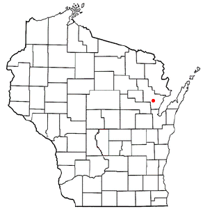
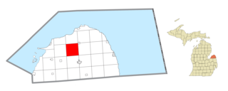
Oconto Falls is a town in Oconto County, Wisconsin, United States. The population was 1,139 at the 2000 census. The City of Oconto Falls is located within the town.

<span class="mw-page-title-main">Meade Township, Huron County, Michigan</span> Civil township in Michigan, United States

Meade Township is a civil township of Huron County in the U.S. state of Michigan. The population was 799 at the 2000 census.

References

  1. "ArcGIS REST Services Directory". United States Census Bureau. Retrieved September 20, 2022.
  2. Gannett, Henry (1905). The Origin of Certain Place Names in the United States. Govt. Print. Off. pp.  133.
  3. "Census of Population and Housing". Census.gov. Archived from the original on May 7, 2015. Retrieved June 4, 2015.