Perry (village), New York

Last updated

Perry, New York
Main Street, Perry, NY.jpg
Main Street, April 2020
USA New York location map.svg
Red pog.svg
Perry, New York
Location within the state of New York
Coordinates: 42°43′1″N78°0′16″W / 42.71694°N 78.00444°W / 42.71694; -78.00444
Country United States
State New York
County Wyoming
Settled1809 (1809)
IncorporatedMay 17, 1830 (1830-05-17)
Named for Oliver Hazard Perry
Area
[1]
  Total2.45 sq mi (6.34 km2)
  Land2.34 sq mi (6.05 km2)
  Water0.11 sq mi (0.29 km2)
Elevation
1,371 ft (418 m)
Population
 (2020)
  Total3,536
  Density1,513.05/sq mi (584.09/km2)
Time zone UTC-5 (Eastern (EST))
  Summer (DST) UTC-4 (EDT)
ZIP code
14530
Area code 585
FIPS code 36-57243
GNIS feature ID0960202
Website www.villageofperry.com
Silver Lake Trail footbridge near Main Street, overlooking secret waterfall behind a 200 year-old former mill. Silver Lake Trail Footbridge 2023.jpg
Silver Lake Trail footbridge near Main Street, overlooking secret waterfall behind a 200 year-old former mill.
The Perry Chalk Art Festival is one of the area's signature events, with dozens of professional artists, producing temporary works of art over a one-day period each summer on the second Saturday in July. Perry Chalk Art Festival 2022.jpg
The Perry Chalk Art Festival is one of the area’s signature events, with dozens of professional artists, producing temporary works of art over a one-day period each summer on the second Saturday in July.

Perry is a village in the towns of Perry and Castile in Wyoming County, New York, United States. The population was 3,673 at the 2010 census. The village is at the junction of state routes 39 and 246.

Contents

History

The Village of Perry was incorporated in 1830.

The Perry Downtown Historic District, First Methodist Episcopal Church of Perry, Brick Presbyterian Church, Barna C. Roup House, and Epworth Hall are listed on the National Register of Historic Places. [2] [3] [4]

On November 27, 2019, Perry signed a Friendship Agreement with the Town of Nailsworth, England.

Amenities

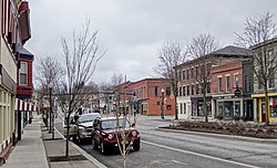
As of 2021, Perry has seen a resurgence with a gain of 36 net new businesses in the past 16 years in the downtown alone. Perry Farmers' Market, founded in 2002, draws 400-600 people to downtown each Saturday morning from mid-June through September. Signature events include Perry Chalk Art Festival, Tour de Perry, Shake on the Lake, New York State Puppet Festival, Silver Serpent Triathlon and Letchworth Arts and Crafts Show. The Village recently renovated its Public Beach, added a Splash Park to its Village Park, completed a Main Street Improvement Project, and a segment of the Silver Lake Trail from the Beach to Main Street.

Demographics

Historical population
CensusPop.Note
1870 867
1880 1,11528.6%
1890 1,52837.0%
1900 2,76380.8%
1910 4,38858.8%
1920 4,7177.5%
1930 4,231−10.3%
1940 4,4685.6%
1950 4,5331.5%
1960 4,6292.1%
1970 4,538−2.0%
1980 4,198−7.5%
1990 4,2190.5%
2000 3,945−6.5%
2010 3,673−6.9%
2020 3,536−3.7%
U.S. Decennial Census [5]

As of the census [6] of 2000, there were 3,945 people, 1,560 households, and 1,051 families residing in the village. The population density was 1,744.8 inhabitants per square mile (673.7/km2). There were 1,764 housing units at an average density of 780.2 per square mile (301.2/km2). The racial makeup of the village was 97.41% White, 0.74% Black or African American, 0.15% Native American, 0.35% Asian, 0.03% Pacific Islander, 0.46% from other races, and 0.86% from two or more races. Hispanic or Latino of any race were 1.55% of the population.

There were 1,560 households, out of which 33.1% had children under the age of 18 living with them, 48.1% were married couples living together, 13.9% had a female householder with no husband present, and 32.6% were non-families. 27.1% of all households were made up of individuals, and 12.9% had someone living alone who was 65 years of age or older. The average household size was 2.48 and the average family size was 2.97.

In the village, the population was spread out, with 25.8% under the age of 18, 8.4% from 18 to 24, 28.2% from 25 to 44, 22.6% from 45 to 64, and 15.0% who were 65 years of age or older. The median age was 37 years. For every 100 females, there were 92.9 males. For every 100 females age 18 and over, there were 88.0 males.

The median income for a household in the village was $35,596, and the median income for a family was $41,090. Males had a median income of $31,845 versus $21,486 for females. The per capita income for the village was $16,794. About 6.5% of families and 8.7% of the population were below the poverty line, including 12.8% of those under age 18 and 2.6% of those age 65 or over.

Government

Perry is governed by a board of trustees composed of a mayor, deputy mayor, and three trustees. The current Board is composed of Mayor Rick Hauser, Deputy Mayor Dariel Draper, and Trustees Jacquie Billings, Arlene Lapiana and Ernie Lawrence.

Geography

Perry is located at 42°43′0″N78°0′16″W / 42.71667°N 78.00444°W / 42.71667; -78.00444 (42.716876, -78.004582). [7]

According to the United States Census Bureau, the village has a total area of 2.4 square miles (6.1 km2), of which 2.3 square miles (5.9 km2) is land and 0.1 square mile (0.3 km2) (4.64%) is water.

Perry is at the northeast end of Silver Lake. It is west of Letchworth State Park and northeast of Silver Lake State Park.

Notable people

See also

Related Research Articles

Belmont is a village within the town of Amity in Allegany County, New York, United States. Belmont is the county seat of Allegany County. The population was 969 at the 2010 census. The name means "beautiful hill". The village is centrally located in Amity and is northeast of Olean.

<span class="mw-page-title-main">Maeystown, Illinois</span> Village in Illinois, United States

Maeystown is a village in Monroe County, Illinois, United States. The population was 150 at the 2020 census.

<span class="mw-page-title-main">Perry, Missouri</span> City in Missouri, United States

Perry is a city in southwest Ralls County, Missouri, United States. The population was 665 at the 2020 census. It is part of the Hannibal Micropolitan Statistical Area.

<span class="mw-page-title-main">Centre Township, Berks County, Pennsylvania</span> Township in Pennsylvania, United States

Centre Township is a township in Berks County, Pennsylvania. The population was 4,140 at the 2020 census. It is in Schuylkill Valley School District.

<span class="mw-page-title-main">Greenwich Township, Berks County, Pennsylvania</span> Township in Pennsylvania, United States

Greenwich Township is a township in Berks County, Pennsylvania, United States. The population was 3,438 at the 2020 census.

<span class="mw-page-title-main">Perry Township, Berks County, Pennsylvania</span> Township in Pennsylvania, United States

Perry Township is a township in Berks County, Pennsylvania, United States. The population was 2,417 at the 2010 census.

<span class="mw-page-title-main">Hopewell Township, Cumberland County, Pennsylvania</span> Township in Pennsylvania, United States

Hopewell Township is a township in Cumberland County, Pennsylvania, United States. The population was 2,329 at the 2010 census, up from 2,096 at the 2000 census.

<span class="mw-page-title-main">Green Lane, Pennsylvania</span> Borough in Pennsylvania, United States

Green Lane is a borough in Montgomery County, Pennsylvania. The population was 490 at the 2020 census. It is part of the Upper Perkiomen School District and Boyertown Area School District.

<span class="mw-page-title-main">Centre Township, Perry County, Pennsylvania</span> Township in Pennsylvania, United States

Centre Township is a township in Perry County, Pennsylvania, United States. The population was 2,537 at the 2020 census.

<span class="mw-page-title-main">Juniata Township, Perry County, Pennsylvania</span> Township in Pennsylvania, United States

Juniata Township is a township in Perry County, Pennsylvania, United States. As of the 2020 census, the township population was 1,531.

<span class="mw-page-title-main">Landisburg, Pennsylvania</span> Borough in Pennsylvania, United States

Landisburg is a borough in Perry County, Pennsylvania, United States. The population was 220 at the 2010 census. It is part of the Harrisburg–Carlisle Metropolitan Statistical Area.

<span class="mw-page-title-main">Tyrone Township, Perry County, Pennsylvania</span> Township in Pennsylvania, United States

Tyrone Township is a township in Perry County, Pennsylvania, United States. The population was 1,905 at the 2020 census. The principal communities in the township are the villages of Green Park, Pennsylvania and Loysville. The township surrounds the borough of Landisburg.

<span class="mw-page-title-main">Shippen Township, Tioga County, Pennsylvania</span> Township in Pennsylvania, United States

Shippen Township is a township in Tioga County, Pennsylvania, United States. The population was 500 at the 2020 census. Two Pennsylvania state parks, Colton Point and Leonard Harrison are in Shippen Township at the Pennsylvania Grand Canyon. The Grand Canyon Airport is also located on Pennsylvania Route 362 in Shippen Township.

<span class="mw-page-title-main">Meggett, South Carolina</span> Town in South Carolina, United States

Meggett is a town in Charleston County, South Carolina, United States. The population was 1,226 at the 2010 census. Meggett is part of the Charleston-North Charleston-Summerville metropolitan area.

<span class="mw-page-title-main">Onley, Virginia</span> Town in Virginia, United States

Onley is a town in Accomack County, Virginia, United States. The population was 516 at the 2010 census.

<span class="mw-page-title-main">Randolph (CDP), New York</span> Hamlet and CDP in New York, United States

Randolph is a hamlet, census-designated place (CDP) and former village in Cattaraugus County, New York, United States. It is located within the town of Randolph. The population of the village was 1,286 at the 2010 census, out of 2,602 in the town as a whole. Randolph borders the community of East Randolph.

<span class="mw-page-title-main">Hamburg (village), New York</span> Village in New York, United States

Hamburg is a village in Erie County, New York, United States. The population was 9,696 at the 2020 census. The village is named after Hamburg, a city in Germany. It is part of the Buffalo–Niagara Falls Metropolitan Statistical Area.

Leicester is a village in the town of Leicester, Livingston County, New York, United States. The population was 468 at the 2010 census, out of 2,200 in the entire town of Leicester. The village and town are named after Leicester Phelps, an early inhabitant.

<span class="mw-page-title-main">Castile, New York</span> Town in New York, United States

Castile is an incorporated town in Wyoming County, New York. The population was 2,873 at the 2000 census. The town is named after the historical region of Castile in Spain. The Town of Castile is on the east border of the county. The town contains a village which is also named Castile.

<span class="mw-page-title-main">Newbury (village), Vermont</span> Village in Vermont, United States

Newbury is an incorporated village in the town of Newbury in Orange County, Vermont, United States. The population was 447 at the 2020 census.

References

  1. "ArcGIS REST Services Directory". United States Census Bureau. Retrieved September 20, 2022.
  2. "National Register Information System". National Register of Historic Places . National Park Service. March 13, 2009.
  3. "National Register of Historic Places Listings". Weekly List of Actions Taken on Properties: 4/16/12 through 4/20/12. National Park Service. April 27, 2012.
  4. "National Register of Historic Places Listings". Weekly List of Actions Taken on Properties: 8/10/15 through 8/14/15. National Park Service. August 21, 2015.
  5. "Census of Population and Housing". Census.gov. Retrieved June 4, 2015.
  6. "U.S. Census website". United States Census Bureau . Retrieved January 31, 2008.
  7. "US Gazetteer files: 2010, 2000, and 1990". United States Census Bureau. February 12, 2011. Retrieved April 23, 2011.