Lake County, Ohio

Last updated

Lake County
Lake County Courthouse.jpg
Lake County Courthouse
Flag of Lake County, Ohio.png
Seal of Lake County Ohio.svg
Lake County, Ohio logo.png
Map of Ohio highlighting Lake County.svg
Location within the U.S. state of Ohio
Ohio in United States.svg
Ohio's location within the U.S.
Coordinates: 41°49′N81°14′W / 41.82°N 81.24°W / 41.82; -81.24
CountryFlag of the United States.svg United States
StateFlag of Ohio.svg  Ohio
FoundedMarch 6, 1840 [1]
Named for Lake Erie
Seat Painesville
Largest city Mentor
Area
  Total979 sq mi (2,540 km2)
  Land227 sq mi (590 km2)
  Water752 sq mi (1,950 km2)  77%
Population
 (2020)
  Total232,603
  Estimate 
(2021)
232,023 Decrease2.svg
  Density240/sq mi (92/km2)
Time zone UTC−5 (Eastern)
  Summer (DST) UTC−4 (EDT)
Congressional district 14th
Website www.lakecountyohio.gov

Lake County is a county in the U.S. state of Ohio. As of the 2020 census, the population was 232,603. [2] Its county seat is Painesville, and its largest city is Mentor.

Contents

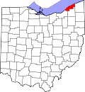
The county was established on March 6, 1840, from land given by Cuyahoga and Geauga counties. Its name is derived from its location on the southern shore of Lake Erie and the fact that the majority of the county’s land has always lied beneath Lake Erie. [3] [4] Lake County is part of the Cleveland, OH Metropolitan Statistical Area.

History

The land that became Lake County was home to the indigenous Erie people prior to the arrival of the French in the region during the early 1600s, and considered by the French to be part of their Colony of New France. Ceded to Great Britain in 1763, the area became part of the Province of Quebec through the Quebec Act of 1774. Following the American Revolutionary War, it became part of the Connecticut Western Reserve in the Northwest Territory, then was purchased by the Connecticut Land Company in 1795. It was separated out of Geauga County in March 1840.

Geography

According to the United States Census Bureau, the county has an area of 979 square miles (2,540 km2), of which 227 square miles (590 km2) is land and 752 square miles (1,950 km2) (77%) is water. [5] It is Ohio's smallest county by land area but the third-largest by total area, with said area owing to land beneath the lake (which is owned by the county).

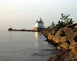
The county’s coast line along Lake Erie spans 31 miles. Additionally, Lake County has an international border with Ontario (across Lake Erie).

Adjacent counties

Major highways

National protected area

Physical geography

Ridges on the Lake Plain physiographic region, and on which some roads are laid, are beaches formed by the various glacial lakes which occurred as the glaciers receded. [6] Lake Maumee was the highest glacial lake at about 760 feet, and left Maumee II beach. Whittlesey beach, formed by Lake Whittlesey at 740 feet, is known as South Ridge. Arkona beach (Lake Arkona) is Middle Ridge, and occurs at about 690 feet. North Ridge is the remnant of Warren beach (Lake Warren), at an elevation of 685 feet. Elkton beach is the northernmost ridge, at 625 feet, an occurred at the time of Lake Elkton. Lake Shore Boulevard follows Elkton beach in Mentor Township.

Mentor Marsh is an Ohio State Nature Preserve. [7] Mentor Marsh is an abandoned channel of the Grand River.

Demographics

Historical population
CensusPop.Note
1840 13,719
1850 14,6546.8%
1860 15,5766.3%
1870 15,9352.3%
1880 16,3262.5%
1890 18,23511.7%
1900 21,68018.9%
1910 22,9275.8%
1920 28,66725.0%
1930 41,67445.4%
1940 50,02020.0%
1950 75,97951.9%
1960 148,70095.7%
1970 197,20032.6%
1980 212,8017.9%
1990 215,4991.3%
2000 227,5115.6%
2010 230,0411.1%
2020 232,6031.1%
2021 (est.)232,023 [8] −0.2%
U.S. Decennial Census [9]
1790-1960 [10] 1900-1990 [11]
1990-2000 [12] 2010-2020 [2]

In 2010, 92.4% spoke English, 2.7% Spanish, and 1.4% Croatian. [13]

2000 census

As of the census [14] of 2000, the county had 227,511 people, 89,700 households, and 62,520 families. The population density was 997 inhabitants per square mile (385/km2). There were 93,487 housing units at an average density of 410 units per square mile (160 units/km2). The county's racial makeup was 95.40% White, 1.99% Black or African American, 0.11% Native American, 0.90% Asian, 0.02% Pacific Islander, 0.66% from other races, and 0.92% from two or more races. 1.70% of the population were Hispanic or Latino of any race. 18.5% were of German, 14.6% Italian, 12.7% Irish, 8.1% English, 6.2% Polish, 5.7% American and 5.4% Slovene ancestry. 93.6% spoke English, 1.9% Spanish, and 0.8% Croatian as their first language. [13]

There were 89,700 households, out of which 31.10% had children under the age of 18 living with them, 56.10% were married couples living together, 10.00% had a female householder with no husband present, and 30.30% were non-families. 25.60% of all households were made up of individuals, and 9.80% had someone living alone who was 65 years of age or older. The average household size was 2.50 and the average family size was 3.03.

The county's population was spread out, with 24.20% under the age of 18, 7.30% from 18 to 24, 29.70% from 25 to 44, 24.70% from 45 to 64, and 14.10% who were 65 years of age or older. The median age was 39 years. For every 100 females there were 94.50 males. For every 100 females age 18 and over, there were 91.50 males.

The county's median household income was $48,763, and the median family income was $57,134. Males had a median income of $40,916 versus $28,434 for females. The county's per capita income was $23,160. About 3.50% of families and 5.10% of the population were below the poverty line, including 6.50% of those under age 18 and 5.40% of those age 65 or over.

2010 census

As of the 2010 census, there were 230,041 people, 94,156 households, and 62,384 families residing in the county. [15] The population density was 1,011.2 inhabitants per square mile (390.4/km2). There were 101,202 housing units at an average density of 444.9 units per square mile (171.8 units/km2). [16] The racial makeup of the county was 92.5% white, 3.2% black or African American, 1.1% Asian, 0.1% American Indian, 1.6% from other races, and 1.5% from two or more races. Those of Hispanic or Latino origin made up 3.4% of the population. [15] In terms of ancestry, 26.4% were German, 18.9% were Irish, 16.4% were Italian, 11.5% were English, 7.6% were Polish, 5.4% were Hungarian, and 3.9% were American. [17]

Of the 94,156 households, 29.4% had children under the age of 18 living with them, 50.5% were married couples living together, 11.2% had a female householder with no husband present, 33.7% were non-families, and 28.3% of all households were made up of individuals. The average household size was 2.41 and the average family size was 2.97. The median age was 42.3 years. [15]

The median income for a household in the county was $54,896 and the median income for a family was $67,206. Males had a median income of $49,240 versus $36,906 for females. The per capita income for the county was $28,221. About 6.0% of families and 8.1% of the population were below the poverty line, including 13.0% of those under age 18 and 4.4% of those age 65 or over. [18]

Environment

Fairport Harbor West Breakwater Light, Fairport Harbor viewed from the Headlands Dunes State Nature Preserve Fairport Harbor West Breakwater Light.jpg
Fairport Harbor West Breakwater Light, Fairport Harbor viewed from the Headlands Dunes State Nature Preserve

Scorecard’s 2002 [19] report ranks Lake County among the worst 10% of counties in the U.S. in terms of cancer risk, developmental and reproductive toxicants, and other categories as well. This rating is comparable with most major cities and densely populated areas. In 2004, Scorecard [19] ranked the county among the cleanest or best 10% of all counties in the U.S. in terms of the number of designated Superfund sites.

Lake County has a large public park system, including Lake Metroparks Farmpark. Kirtland is home to the Holden Arboretum and Gildersleeve Mountain. Headlands Beach State Park is in Mentor. The Grand River is a state wild and scenic river, and the Chagrin River is a state scenic river.

Transportation

Laketran is the transit agency servicing Lake County. Interstate 90 runs northeast–southwest through Lake County, roughly parallel to State Route 2; along with the north–south State Route 44 connecting the two together. These freeways make up the major traffic arteries in the county. Lake County does not have passenger rail service, though Amtrak's New York City-Chicago "Lake Shore Limited" service schedules an eastbound and westbound train through Lake County nightly with stops at Cleveland and Erie. CSXT (former Conrail, née-Penn Central, née-New York Central) and Norfolk Southern (née-Norfolk & Western, née-Nickel Plate Road) provide railroad main line through-freight service. The recently formed Grand River Railroad, operating on former Baltimore & Ohio track, serves the Fairport Harbor area linking the Morton Salt plant with CSXT at Painesville.

Library services

The following libraries serve Lake County:

Additionally, as of 2019, all Lake County libraries are all CLEVNET members.

Politics

Lake County is known as a "purple" or "swing" county within the state. A 2008 analysis of Ohio presidential election results from 1960 to 2004 found no other county more closely follows the statewide Ohio voting pattern. [22] Lake County does not always vote with the winner, but consistently is closer to the winner's Ohio vote percentage than any other Ohio county.

United States presidential election results for Lake County, Ohio [23]
Year Republican Democratic Third party
No.%No.%No.%
2020 73,27856.03%55,51442.45%1,9901.52%
2016 64,25554.83%46,39739.59%6,5385.58%
2012 58,74449.50%57,68048.61%2,2411.89%
2008 59,14248.62%60,15549.45%2,3451.93%
2004 62,19351.05%59,04948.47%5810.48%
2000 51,74750.45%46,49745.33%4,3204.21%
1996 40,97441.92%43,18644.19%13,57613.89%
1992 40,76638.46%37,68235.55%27,54225.99%
1988 52,96356.63%39,66742.41%8940.96%
1984 54,58759.12%36,71139.76%1,0271.11%
1980 43,48550.31%35,24640.78%7,6978.91%
1976 36,39045.83%40,73451.30%2,2842.88%
1972 42,48858.90%27,52338.15%2,1302.95%
1968 28,45043.40%27,93242.61%9,17714.00%
1964 23,28237.65%38,55262.35%00.00%
1960 32,03848.94%33,42551.06%00.00%
1956 31,01761.14%19,71838.86%00.00%
1952 23,48360.48%15,34639.52%00.00%
1948 12,97353.81%10,84444.98%2911.21%
1944 13,69751.86%12,71348.14%00.00%
1940 13,46452.04%12,40847.96%00.00%
1936 9,38643.24%11,21351.66%1,1085.10%
1932 11,79261.43%6,80135.43%6033.14%
1928 11,82374.24%4,02425.27%790.50%
1924 7,72770.71%9748.91%2,22620.37%
1920 7,46572.31%2,71126.26%1471.42%
1916 2,88751.39%2,59646.21%1352.40%
1912 1,15522.91%1,42928.34%2,45848.75%
1908 3,63566.97%1,60529.57%1883.46%
1904 3,82476.42%87117.41%3096.18%
1900 3,92968.41%1,73330.18%811.41%
1896 3,74568.40%1,68230.72%480.88%
1892 2,84667.46%1,15827.45%2155.10%
1888 2,98768.37%1,15726.48%2255.15%
1884 2,92569.64%1,12026.67%1553.69%
1880 2,97871.06%1,10426.34%1092.60%
1876 2,94171.28%1,14127.65%441.07%
1872 2,75173.56%97926.18%100.27%
1868 2,90976.59%88923.41%00.00%
1864 2,78782.63%58617.37%00.00%
1860 2,52177.74%62219.18%1003.08%
1856 2,37178.04%62820.67%391.28%

Communities

Map of Lake County, Ohio with Municipal and Township Labels Map of Lake County Ohio With Municipal and Township Labels.PNG
Map of Lake County, Ohio with Municipal and Township Labels

Cities

Villages

Townships

Census-designated place

Unincorporated communities

See also

Related Research Articles

<span class="mw-page-title-main">Monroe County, Ohio</span> County in Ohio, United States

Monroe County is a county located on the eastern border of the U.S. state of Ohio, across the Ohio River from West Virginia. As of the 2020 census, the population was 13,385, making it the second-least populous county in Ohio. Its county seat is Woodsfield. The county was created in 1813 and later organized in 1815.

<span class="mw-page-title-main">Mahoning County, Ohio</span> County in Ohio, United States

Mahoning County is a county in the U.S. state of Ohio. As of the 2020 census, the population was 228,614. Its county seat and largest city is Youngstown. The county is named after the Mahoning River and was formed on March 1, 1846; the 83rd county in Ohio.

<span class="mw-page-title-main">Lucas County, Ohio</span> County in Ohio, United States

Lucas County is a county located in the northwestern part of the U.S. state of Ohio. It is bordered to the east by Lake Erie, and to the southeast by the Maumee River, which runs to the lake. As of the 2020 census, the population was 431,279. Its county seat and largest city is Toledo, located at the mouth of the Maumee River on the lake. The county was named for Robert Lucas, 12th governor of Ohio, in 1835 during his second term. Its establishment provoked the Toledo War conflict with the Michigan Territory, which claimed some of its area. Lucas County is the central county of the Toledo Metropolitan Statistical Area.

<span class="mw-page-title-main">Erie County, Ohio</span> County in Ohio, United States

Erie County is a county located in the northern portion of the U.S. state of Ohio. As of the 2020 census, the population was 75,622. Its county seat and largest city is Sandusky. The county is named for the Erie tribe, whose name was their word for "wildcat". It was formed in 1838 from the northern third of Huron County and a portion of Sandusky County.

<span class="mw-page-title-main">Carroll County, Ohio</span> County in Ohio, United States

Carroll County is a county located in the state of Ohio. As of the 2020 census, the population was 26,721. Its county seat is Carrollton, while its largest village is Minerva. It is named for Charles Carroll of Carrollton, the last surviving signer of the Declaration of Independence. Carroll County is part of the Canton-Massillon, OH Metropolitan Statistical Area, which is also included in the Cleveland-Akron-Canton, OH Combined Statistical Area. It is in the Appalachian Ohio region.

<span class="mw-page-title-main">Ashtabula County, Ohio</span> County in Ohio, United States

Ashtabula County is the northeasternmost county in the U.S. state of Ohio. As of the 2020 census, the population was 97,574. The county seat is Jefferson, while its largest city is Ashtabula. The county was created in 1808 and later organized in 1811. The name Ashtabula derives from the Lenape language phrase ashte-pihële, which translates to 'always enough (fish) to go around, to be given away' and is a contraction of apchi ('always') + tepi ('enough') + hële. Ashtabula County is part of the Cleveland, OH Metropolitan Statistical Area.

<span class="mw-page-title-main">Eastlake, Ohio</span> City in Ohio, United States

Eastlake is a city in Lake County, Ohio, United States. It takes its name from its location northeast of Cleveland, following along the shore of Lake Erie. The population was 17,670 at the 2020 census. The 2003 North America blackout stemmed from an Eastlake generating station going offline.

<span class="mw-page-title-main">Fairport Harbor, Ohio</span> Village in Ohio, United States

Fairport Harbor is a village in Lake County, Ohio, United States, along Lake Erie at the mouth of the Grand River. The population was 3,108 at the 2020 census. A far-eastern suburb of Cleveland, it is part of the Cleveland metropolitan area.

<span class="mw-page-title-main">Kirtland Hills, Ohio</span> Village in Ohio, United States

Kirtland Hills is a village in Lake County, Ohio, United States and a rural suburb of Cleveland. The population was 692 at the 2020 census.

<span class="mw-page-title-main">Mentor, Ohio</span> City in Ohio, United States

Mentor is the largest city in Lake County, Ohio, United States. The population was 47,450 at the 2020 census. It is part of the Cleveland metropolitan area.

<span class="mw-page-title-main">Painesville, Ohio</span> City in Ohio, United States

Painesville is a city in and the county seat of Lake County, Ohio, United States, located along the Grand River 27 miles (43 km) It is a northeast suburb of Cleveland. Its population was 20,312 at the 2020 census. Painesville is part of the Greater Cleveland Metropolitan Area and is included in the Cleveland-Akron-Canton, Ohio Consolidated Metropolitan Statistical Area.

<span class="mw-page-title-main">Timberlake, Ohio</span> Village in Ohio, United States

Timberlake is a village in Lake County, Ohio, United States. The population was 629 at the 2020 census.

<span class="mw-page-title-main">Willoughby, Ohio</span> City in Ohio, United States

Willoughby is a city in Lake County, Ohio, United States, along the Chagrin River. The population was 23,959 at the time of the 2020 census. A suburb of Cleveland, it is part of the Cleveland metropolitan area.

<span class="mw-page-title-main">Willoughby Hills, Ohio</span> City in Ohio, United States

Willoughby Hills is a city in Lake County, Ohio, United States, along the Chagrin River. The population was 10,019 at the 2020 census. A suburb of Cleveland, it is part of the Cleveland metropolitan area.

<span class="mw-page-title-main">Willowick, Ohio</span> City in Ohio, United States

Willowick is a city in Lake County, Ohio, United States, on Lake Erie. The population was 14,204 at the 2020 census. A suburb of Cleveland, Willowick is served by a branch of the Willoughby-Eastlake Public Library. The city's name is a portmanteau of two adjacent cities, Willoughby and Wickliffe. As of 2022, the mayor of Willowick is Michael Vanni.

<span class="mw-page-title-main">Vermilion, Ohio</span> City in Ohio, United States

Vermilion is a city in Erie and Lorain Counties in the U.S. state of Ohio, on Lake Erie. Its population was 10,659 at the 2020 census. Located about 35 miles west of Cleveland and 17 miles east of Sandusky, it is part of the Cleveland metropolitan area and Sandusky micropolitan area.

<span class="mw-page-title-main">Ripley, New York</span> Town in New York, United States

Ripley is a town on Lake Erie in the westernmost part of Chautauqua County, New York, United States. The population was 2,310 at the time of the 2020 census. The town was named after Eleazer Wheelock Ripley, a general in the War of 1812. There are no incorporated villages in the town, but there is one census-designated place: the hamlet of Ripley. The town is perhaps best known as being the western terminus of the New York State Thruway.

<span class="mw-page-title-main">Concord Township, Lake County, Ohio</span> Township in Ohio, United States

Concord Township is one of the five townships of Lake County, Ohio, United States. As of the 2020 census, the population was 19,254. Lake County is part of the Cleveland-Elyria, OH Metropolitan Statistical Area.

<span class="mw-page-title-main">Painesville Township, Lake County, Ohio</span> Township in Ohio, United States

Painesville Township is one of the five townships of Lake County, Ohio, United States. The population was 20,453 at the 2020 census. It is a part of Greater Cleveland in the Northeast Ohio Region, and is included in the Cleveland-Akron-Canton, Ohio combined statistical area in the United States.

<span class="mw-page-title-main">John Rogers (Ohio politician)</span> American politician

John M. Rogers is a former Democratic member of the Ohio House of Representatives, representing the 60th District which includes the Lake County communities of Eastlake, Fairport Harbor, Grand River, Lakeline, Mentor-on-the-Lake, Painesville, Timberlake, Wickliffe, Willoughby, Willowick, as well as parts of both Mentor and Painesville Township. He was first elected in 2012.

References

  1. "Ohio County Profiles: Lake County" (PDF). Ohio Department of Development. Archived from the original (PDF) on March 18, 2004. Retrieved April 28, 2007.
  2. 1 2 "State & County QuickFacts". United States Census Bureau. Retrieved July 14, 2022.
  3. "Lake County data". Ohio State University Extension Data Center. Retrieved April 28, 2007.[ dead link ]
  4. summertorok (March 9, 2023). "Lake County Commissioners Celebrate Lake County's 183rd Birthday". Commissioners' Office. Retrieved December 21, 2023.
  5. "2010 Census Gazetteer Files". United States Census Bureau. August 22, 2012. Archived from the original on May 4, 2014. Retrieved February 8, 2015.
  6. White, George W. (1980). Glacial Geology of Lake County, Ohio (PDF). Columbus, Ohio: State of Ohio Department of Natural Resources Division of Geological Survey. p. 8.
  7. "Mentor Marsh State Nature Preserve". State of Ohio Department of Natural Resources. Retrieved October 26, 2019.
  8. "Annual Estimates of the Resident Population for Counties: April 1, 2020 to July 1, 2021" . Retrieved July 14, 2022.
  9. "U.S. Decennial Census". United States Census Bureau. Retrieved February 8, 2015.
  10. "Historical Census Browser". University of Virginia Library. Retrieved February 8, 2015.
  11. Forstall, Richard L., ed. (March 27, 1995). "Population of Counties by Decennial Census: 1900 to 1990". United States Census Bureau. Retrieved February 8, 2015.
  12. "Census 2000 PHC-T-4. Ranking Tables for Counties: 1990 and 2000" (PDF). United States Census Bureau. April 2, 2001. Archived (PDF) from the original on March 27, 2010. Retrieved February 8, 2015.
  13. 1 2 "Data Center Results". Archived from the original on August 15, 2013. Retrieved August 7, 2013.
  14. "U.S. Census website". United States Census Bureau . Retrieved January 31, 2008.
  15. 1 2 3 "DP-1 Profile of General Population and Housing Characteristics: 2010 Demographic Profile Data". United States Census Bureau. Archived from the original on February 13, 2020. Retrieved December 27, 2015.
  16. "Population, Housing Units, Area, and Density: 2010 - County". United States Census Bureau. Archived from the original on February 13, 2020. Retrieved December 27, 2015.
  17. "DP02 SELECTED SOCIAL CHARACTERISTICS IN THE UNITED STATES – 2006-2010 American Community Survey 5-Year Estimates". United States Census Bureau. Archived from the original on February 13, 2020. Retrieved December 27, 2015.
  18. "DP03 SELECTED ECONOMIC CHARACTERISTICS – 2006-2010 American Community Survey 5-Year Estimates". United States Census Bureau. Archived from the original on February 13, 2020. Retrieved December 27, 2015.
  19. 1 2 "scorecard.org". Archived from the original on May 6, 2021. Retrieved May 29, 2021.
  20. "HAPLR Top Ten by Population". HAPLR Index. Archived from the original on March 23, 2009. Retrieved December 26, 2009.
  21. 1 2 "2005 Ohio Public Library Statistics:Statistics by County and Town". State Library of Ohio. Archived from the original on September 24, 2006. Retrieved October 28, 2006.
  22. Exner, Rich (August 19, 2008). "Ohio's presidential election bellwether: Lake County". Cleveland Plain Dealer. Archived from the original on October 26, 2012. Retrieved June 24, 2012.
  23. Leip, David. "Dave Leip's Atlas of U.S. Presidential Elections". uselectionatlas.org. Retrieved May 2, 2018.

41°49′N81°14′W / 41.82°N 81.24°W / 41.82; -81.24