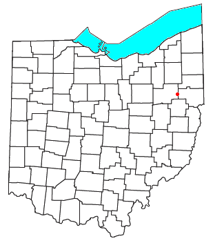
Painesville is a city in and the county seat of Lake County, Ohio, United States, located along the Grand River 27 miles (43 km) northeast of Cleveland. Its population was 20,312 at the 2020 census.
Fleming is a small unincorporated community in rural eastern Barlow Township, Washington County, Ohio, United States.

Germantown is an unincorporated community in northern Liberty Township, Washington County, Ohio, United States. It lies along the Paw Paw Creek near the boundary with Noble County.
Skytop is an unincorporated community in Barrett Township, Monroe County, Pennsylvania, United States. Located north of Mountainhome, it is accessible by local roads off Route 390. Its elevation is 1,562 feet (476 m), and it is located at 41°13′40″N75°14′18″W. Although Skytop is unincorporated, it has a post office, with the ZIP code of 18357; the ZCTA for ZIP Code 18357 had a population of 87 at the 2000 census.

Lake Health, formerly Lake Hospital System, is a system of hospitals and health care facilities throughout Lake County, Cuyahoga County and Geauga County, Ohio, United States. Lake Health changed its name from Lake Hospital System on June 12, 2009. On April 16, 2021, the Lake Health system became part of University Hospitals.

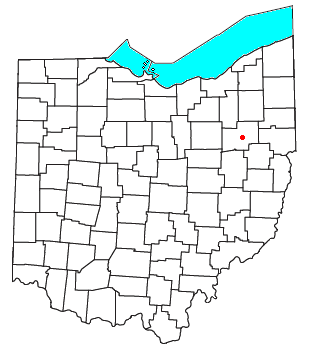
Painesville Township is one of the five townships of Lake County, Ohio, United States. The population was 20,453 at the 2020 census. It is part of Greater Cleveland in the Northeast Ohio Region, the 15th largest combined statistical area in the United States.

Wingett Run is an unincorporated community in western Ludlow Township, Washington County, Ohio, United States. It has a post office with the ZIP code 45789. It is located along State Route 26 and the Little Muskingum River.

Bartlett is an unincorporated community in southwestern Wesley Township, Washington County, Ohio, United States. It has a post office with the ZIP code 45713. It sits at the intersection of State Routes 550 and 555 near Coal Run, a subsidiary of Wolf Creek, which meets the Muskingum River at Waterford to the north. Near Bartlett is located the Shinn Covered Bridge, which spans Wolf Creek.

Barlow is an unincorporated community in western Barlow Township, Washington County, Ohio, United States. Although it is unincorporated, it has a ZIP code 45712. It lies at the intersection of State Routes 339 and 550 near the South Fork of Wolf Creek, which meets the Muskingum River at Waterford to the north.

Brentwood Lake is an unincorporated community in far eastern Carlisle Township, Lorain County, Ohio, United States. It lies at the intersection of State Routes 57 and 82 midway between Elyria and Grafton. Located at the center of the planned community was a small lake, compliments of an earthen dam from which a small stream flows to the East Branch Black River that runs just to the west of the community. The earthen dam was dismantled in 2010 for safety reasons and today there is only a small stream without a lake. Alfred M. Moen, the inventor of the Moen faucet, was a past resident of the lakeside community.

Birmingham is an unincorporated community in southeastern Monroe Township, Guernsey County, Ohio, United States. It lies at the intersection of Beal, Birmingham, and Peoli Roads, 3+3⁄4 miles (6.0 km) south of Peoli, 7 miles east-northeast of Kimbolton, and 13 miles (21 km) northeast of central Cambridge, the county seat of Guernsey County. Nearby streams flow southward into Salt Fork Lake, which is included in Salt Fork State Park.

Assumption is a small unincorporated community and also a historically Irish (Catholic) community in southern Amboy Township, Fulton County, Ohio, United States. A part of the Toledo Metropolitan Area, it lies seven miles from the northern edge of Swanton. It is located at roughly 41°40'N, 83°55'W.

Avondale is an unincorporated community in southwestern Plain Township, Stark County, Ohio, United States. Located just northwest of Canton and north of Meyers Lake, its altitude is 1,135 feet (346 m).

Cairo is an unincorporated community that lies upon the border of Lake Township and Plain Township within Stark County, Ohio, United States. Its altitude is 1,145 feet (349 m). The community is part of the Canton–Massillon Metropolitan Statistical Area.
New Franklin is an unincorporated community in northeastern Paris Township, Stark County, Ohio, United States, lying at the intersection of State Routes 172 and 183. The community is part of the Canton–Massillon Metropolitan Statistical Area.
Waco is an unincorporated community in central Canton Township, Stark County, Ohio, United States. It lies along State Route 43 just southeast of the Canton city line. Waco's altitude is 1,070 feet (326 m) The community is part of the Canton–Massillon Metropolitan Statistical Area.

Morley Library, located at 184 Phelps St. in Painesville, Ohio serves as the County District Library for Lake County, Ohio. Morley Library is a medium-sized public library that is supported by both state funds and a local tax levy. The original library was founded in 1899. Its mission is to "be a community resource, available to all, contributing to the quality of life in its service area by: providing information for life-long learning and recreation in an organized, professional manner; extending outreach to encourage Library use; serving as a focal point for the community". In 2007, Morley Library was visited by 342,870 people and circulated 689,694 items. The collection includes 180,490 items. Morley Library serves 48,650 people in Painesville City, Painesville Township, Grand River, Leroy Township, and part of Concord Township.

The Little Hocking River is a small tributary of the Ohio River, 18.4 miles (29.6 km) long, in southeastern Ohio in the United States. Via the Ohio River, it is part of the watershed of the Mississippi River, draining an area of 102 square miles (260 km2) on the unglaciated portion of the Allegheny Plateau. The river flows for its entire length in southwestern Washington County; its tributaries also drain a small area of southeastern Athens County.
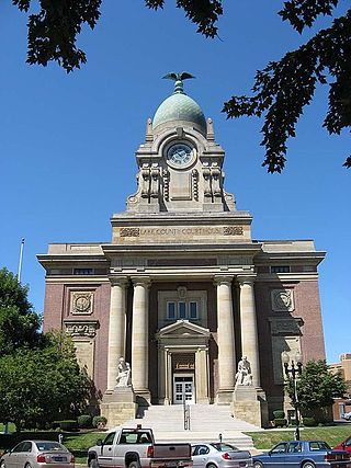
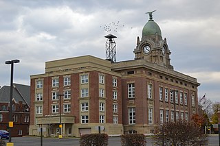
Lake County Courthouse located in Painesville, Ohio was designed in an eclectic Beaux-Arts style by Cleveland architect J. Milton Dyer. It was completed in 1909.

The Joseph Sawyer House, also known as the Sawyer-Barrow house and the summer estate Twin Maples, was built c. 1825 for Joseph Sawyer (1778-1849) by the Western Reserve's master builder Jonathan Goldsmith. The house is located in Mentor, Ohio.

