Timberlake, Ohio | |
---|---|
Coordinates: 41°39′56″N81°26′34″W / 41.66556°N 81.44278°W | |
Country | United States |
State | Ohio |
County | Lake |
Incorporated | 1947 |
Government | |
• Mayor | John Marra (R) [1] |
Area | |
• Total | 0.21 sq mi (0.55 km2) |
• Land | 0.21 sq mi (0.55 km2) |
• Water | 0.00 sq mi (0.00 km2) |
Elevation | 617 ft (188 m) |
Population (2020) | |
• Total | 629 |
• Density | 2,981.04/sq mi (1,151.01/km2) |
Time zone | UTC-5 (Eastern (EST)) |
• Summer (DST) | UTC-4 (EDT) |
ZIP code | 44095 |
Area code | 440 |
FIPS code | 39-76834 [4] |
GNIS feature ID | 1086432 [3] |
Timberlake is a village in Lake County, Ohio, United States. The population was 629 at the 2020 census.
According to the United States Census Bureau, the village has a total area of 0.21 square miles (0.54 km2), all land. [5]
Timberlake is nearly completely surrounded by Eastlake, with one entrance to the village coming through Lakeline, and the remaining portion bordering Lake Erie.
Census | Pop. | Note | %± |
---|---|---|---|
1950 | 236 | — | |
1960 | 670 | 183.9% | |
1970 | 964 | 43.9% | |
1980 | 885 | −8.2% | |
1990 | 833 | −5.9% | |
2000 | 775 | −7.0% | |
2010 | 675 | −12.9% | |
2020 | 629 | −6.8% | |
U.S. Decennial Census [6] |
As of the census [7] of 2010, there were 675 people, 295 households, and 206 families living in the village. The population density was 3,214.3 inhabitants per square mile (1,241.0/km2). There were 307 housing units at an average density of 1,461.9 per square mile (564.4/km2). The racial makeup of the village was 96.3% White, 0.6% African American, 0.6% Native American, 0.6% Asian, 1.2% from other races, and 0.7% from two or more races. Hispanic or Latino of any race were 2.4% of the population.
There were 295 households, of which 22.7% had children under the age of 18 living with them, 58.6% were married couples living together, 7.8% had a female householder with no husband present, 3.4% had a male householder with no wife present, and 30.2% were non-families. 26.4% of all households were made up of individuals, and 10.8% had someone living alone who was 65 years of age or older. The average household size was 2.29 and the average family size was 2.75.
The median age in the village was 49.6 years. 18.2% of residents were under the age of 18; 4.2% were between the ages of 18 and 24; 19% were from 25 to 44; 36.2% were from 45 to 64; and 22.4% were 65 years of age or older. The gender makeup of the village was 49.2% male and 50.8% female.
As of the census [4] of 2000, there were 775 people, 309 households, and 225 families living in the village. The population density was 3,614.1 inhabitants per square mile (1,395.4/km2). There were 321 housing units at an average density of 1,496.9 per square mile (578.0/km2). The racial makeup of the village was 99.10% White, 0.26% Asian, 0.26% from other races, and 0.39% from two or more races. Hispanic or Latino of any race were 1.42% of the population. 20.6% were of German, 16.4% Italian, 10.7% Irish, 8.0% Slovene, 5.7% English and 5.6% Polish ancestry according to Census 2000.
There were 309 households, out of which 24.3% had children under the age of 18 living with them, 63.4% were married couples living together, 6.5% had a female householder with no husband present, and 26.9% were non-families. 23.3% of all households were made up of individuals, and 7.4% had someone living alone who was 65 years of age or older. The average household size was 2.51 and the average family size was 2.96.
In the village, the population was spread out, with 19.4% under the age of 18, 7.0% from 18 to 24, 23.1% from 25 to 44, 34.1% from 45 to 64, and 16.5% who were 65 years of age or older. The median age was 46 years. For every 100 females there were 98.7 males. For every 100 females age 18 and over, there were 92.9 males.
The median income for a household in the village was $52,422, and the median income for a family was $57,604. Males had a median income of $40,536 versus $33,125 for females. The per capita income for the village was $24,078. About 0.9% of families and 1.4% of the population were below the poverty line, including 0.7% of those under age 18 and 1.6% of those age 65 or over.
Oakfield is a town in Aroostook County, Maine, United States. The population was 661 at the 2020 census. The village of Oakfield, listed as a census-designated place, is in the northwestern corner of the town.
Shoreham is a village in Berrien County in the U.S. state of Michigan. The population was 844 at the 2020 census. The village is located within St. Joseph Charter Township on the shore of Lake Michigan, just south of the City of St. Joseph.
Lyons is a village in Ionia County in the U.S. state of Michigan. The population was 789 at the 2010 census. Most of the village is within Lyons Township. A small portion extends west into Ionia Township.
Pasadena Park is a village in St. Louis County, Missouri, United States. The population was 470 at the 2010 census. It is part of the Normandy School District, and is distinct from the city of Pasadena Hills.
Country Club is a village in Andrew County, Missouri, United States. The population was 2,487 at the 2020 census. It is part of the St. Joseph, MO–KS Metropolitan Statistical Area.
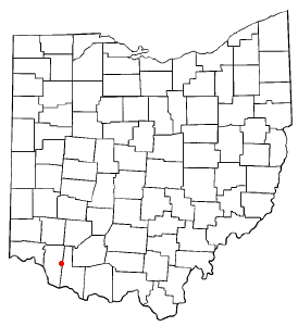
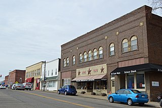
Williamsburg is a village in Clermont County, Ohio, United States. The population was 2,570 at the 2020 census.
New Weston is a village in Darke County, Ohio, United States. The population was 124 at the 2020 census.
Amberley, locally known as Amberley Village, is a village in Hamilton County, Ohio, United States. The population was 3,840 at the 2020 census.
Golf Manor is a village in Hamilton County, Ohio, United States. It is almost completely surrounded by the Pleasant Ridge and Roselawn neighborhoods of Cincinnati. The population was 3,814 at the 2020 census.
Woodlawn is a village in Hamilton County, Ohio, United States. The population was 3,916 at the 2020 census.
Liberty Center is a village in Henry County, Ohio, United States. The population was 1,108 at the 2020 census.
Glenmont is a village in Holmes County, Ohio, United States. The population was 240 at the 2020 census.
Centerburg is a village in Knox County, Ohio, United States, along the North Fork of the Licking River. As of the 2020 census, the village population was 1,690. Centerburg is located near the geographical center of Ohio.
Hebron is a village in Licking County, Ohio, United States. The population was 2,326 at the 2020 census.
Syracuse is a village in Meigs County, Ohio, United States, along the Ohio River. The population was 781 at the 2020 census.
Melrose is a village in Paulding County, Ohio, United States. The population was 233 at the 2020 census.
West Leipsic is a village in Putnam County, Ohio, United States. The population was 226 at the 2020 census.
Bettsville is a village in Seneca County, Ohio, United States. The population was 595 at the 2020 census.
McDonald is a village in southern Trumbull County, Ohio, United States, along the Mahoning River. The population was 3,172 at the 2020 census. It is a suburb of the Youngstown–Warren metropolitan area.
Nashotah is a village in Waukesha County, Wisconsin, United States. The population was 1,321 at the 2020 census. The village took its name from the nearby Nashotah Lakes.