North Madison, Ohio

Last updated

North Madison, Ohio
OHMap-doton-North Madison.png
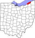
Location of North Madison, Ohio
Coordinates: 41°49′47″N81°03′03″W / 41.82972°N 81.05083°W / 41.82972; -81.05083
Country United States
State Ohio
County Lake
Township Madison
Area
[1]
  Total3.91 sq mi (10.12 km2)
  Land3.91 sq mi (10.12 km2)
  Water0.00 sq mi (0.00 km2)
Elevation
[2]
604 ft (184 m)
Population
 (2020)
  Total8,188
  Density2,095.73/sq mi (809.07/km2)
Time zone UTC-5 (Eastern (EST))
  Summer (DST) UTC-4 (EDT)
ZIP code
44057
Area code 440
FIPS code 39-56812 [3]
GNIS feature ID2393153 [2]

North Madison is a census-designated place (CDP) comprising the unincorporated communities of Redbird and Madison-on-the-Lake [4] in Lake County, Ohio, United States. The population was 8,188 at the 2020 census. The area uses a mailing address of "Madison", with the ZIP Code 44057. [5]

Contents

Geography

The North Madison CDP is located in northeastern Lake County along the shore of Lake Erie in the northern part of Madison Township. The area known as POTATO is in the eastern part of the CDP, and Madison-on-the-Lake is in the northern part. [6] The CDP is located 1 mile (1.6 km) north of the unincorporated community of North Madison and U.S. Route 20. [7] [4] It is 4 miles (6 km) north of the village of Madison, Ohio Madison, 7 miles (11 km) northwest of Geneva, and 9 miles (14 km) northeast of Perry, Ohio Perry.

According to the United States Census Bureau, the CDP has a total area of 3.9 square miles (10.1 km2), all of it land. [8]

Demographics

Historical population
CensusPop.Note
2020 8,188
U.S. Decennial Census [9]

As of the 2010 census [3] of 2010, there were 8,547 people, 3,323 households, and 2,306 families residing in the CDP. The population density was 2,120.2 inhabitants per square mile (818.6/km2). There were 3,323 housing units at an average density of 852.5 per square mile (329.2/km2). The racial makeup of the CDP was 98.4% White, 0.9% African American, 0.8% Native American, 0.38% Asian, 0.6% from other races, and 0.6% from two or more races. Hispanic or Latino of any race were 1.8% of the population.

There were 3,077 households, out of which 32.5% had children under the age of 18 living with them, 50.7% were married couples living together, 12.5% had a female householder with no husband present, and 30.6% were non-families. 24.8% of all households were made up of individuals, and 8.6% had someone living alone who was 65 years of age or older. The average household size was 2.57 and the average family size was 3.05.

In the CDP, the population was spread out, with 25.8% under the age of 18, 8.6% from 18 to 24, 27.0% from 25 to 44, 27.6% from 45 to 64, and 12.0% who were 65 years of age or older. The median age was 38.5 years. For every 100 females, there were 97.1 males. For every 100 females age 18 and over, there were 94.5 males.

The median income for a household in the CDP was -$44,535, and the median income for a family was -$48,709. Males had a median income of -$40,207 versus -$23,689 for females. The per capita income for the CDP was -$18,473. About 4.8% of families and 5.9% of the population were below the poverty line, including 7.4% of those under age 18 and 4.8% of those age 65 or over.

Related Research Articles

<span class="mw-page-title-main">Willow Street, Pennsylvania</span> Census-designated place in Pennsylvania, United States

Willow Street is an unincorporated community and census-designated place (CDP) in Lancaster County, Pennsylvania, United States. The population was 7,578 at the 2010 census. In the early part of the 20th century, the main thoroughfare in town was lined with willow trees on both sides for the length of the town, hence the community's name. As time passed and the town grew, the road was widened and sidewalks were installed, which required the trees be removed. Only a few of the original trees remain to this day.

Forest Lake is an unincorporated community and census-designated place (CDP) in Ela Township of Lake County, Illinois, United States. It is about 35 miles (56 km) northwest of downtown Chicago. Per the 2020 census, the population was 1,784. The community was founded in 1935 as a vacation community for Chicago residents.

Lake Catherine is an unincorporated community and census-designated place (CDP) in Lake County, Illinois, United States. Per the 2020 census, the population was 1,279.

Long Lake is an unincorporated community and census-designated place (CDP) in Lake County, Illinois, United States. Per the 2020 census, the population was 3,663.

Venetian Village is a census-designated place (CDP) in Lake County, Illinois, United States. Per the 2020 census, the population was 2,761.

Rosewood Heights is an unincorporated community and census-designated place (CDP) in Madison County, Illinois, United States. The population was 3,971 at the 2020 census. It is part of the Metro East region of the Greater St. Louis metropolitan area.

<span class="mw-page-title-main">Hidden Valley, Indiana</span> Census-designated place in Indiana, United States

Hidden Valley is a private residential community in Dearborn County, Indiana, United States. For statistical purposes it is a census-designated place (CDP), with a population of 5,387 at the 2010 census, up from 4,417 at the 2000 census.

<span class="mw-page-title-main">Canada Creek Ranch, Michigan</span> Census-designated place in Michigan, United States

Canada Creek Ranch is an unincorporated community in Montmorency Township, Montmorency County, in the U.S. state of Michigan. It is a census-designated place (CDP) used for statistical purposes. The population was 258 at the 2020 census, down from 304 in 2010.

Naytahwaush is a census-designated place (CDP) in Mahnomen County, Minnesota, United States. The population was 504 at the 2020 census.

<span class="mw-page-title-main">Jette, Montana</span> Census-designated place in Montana, United States

Jette is a census-designated place (CDP) in Lake County, Montana, United States. The population was 253 at the 2010 census.

<span class="mw-page-title-main">Crystal Lakes, Ohio</span> Census-designated place in Ohio, United States

Crystal Lakes is a census-designated place (CDP) in Clark County, Ohio, United States. The population was 1,394 at the 2020 census. It is part of the Springfield, Ohio Metropolitan Statistical Area.

<span class="mw-page-title-main">Glenmoor, Ohio</span> Census-designated place in Ohio, United States

Glenmoor is an unincorporated community and census-designated place in southwestern St. Clair Township, Columbiana County, Ohio, United States. The population was 1,829 at the 2020 census. Glenmoor is located in the Salem micropolitan area and the greater Youngstown–Warren area.

<span class="mw-page-title-main">Fairfield Beach, Ohio</span> Census-designated place in Ohio, United States

Fairfield Beach is an unincorporated community and census-designated place (CDP) in Fairfield County, Ohio, United States. The population was 1,267 at the 2020 census.

<span class="mw-page-title-main">Lake Darby, Ohio</span> Census-designated place in Ohio, United States

Lake Darby is an unincorporated community and census-designated place in Franklin County, Ohio, United States, located mostly in Prairie Township and partly in Brown Township. It is more commonly known among locals as Darby Estates, which is also the name of the older housing development there, with the newer development called "West Point". As of the 2020 census, the CDP had a population of 4,731.

<span class="mw-page-title-main">Granville South, Ohio</span> Census-designated place in Ohio, United States

Granville South is a census-designated place (CDP) in Licking County, Ohio, United States. The population was 1,420 at the 2020 census.

<span class="mw-page-title-main">Harbor Hills, Ohio</span> Census-designated place in Ohio, United States

Harbor Hills is a census-designated place (CDP) in southern Licking County, Ohio, United States. The population was 1,565 at the 2020 census.

<span class="mw-page-title-main">Eaton Estates, Ohio</span> Census-designated place in Ohio, United States

Eaton Estates is an unincorporated community and census-designated place (CDP) in Lorain County, Ohio, United States. The population was 1,155 at the 2020 census.

<span class="mw-page-title-main">Choctaw Lake, Ohio</span> CDP in Ohio, United States

Choctaw Lake is a census-designated place (CDP) in Madison County, Ohio, United States. The population was 2,047 at the 2020 census.

Bainbridge is a census-designated place (CDP) in Bainbridge Township, Geauga County, Ohio, United States. As of the 2020 census, the CDP had a population of 9,242.

Madison Place is a census-designated place (CDP) in Hamilton County, Ohio, United States, adjacent to the city of Cincinnati. It was first listed as a CDP prior to the 2020 census. The population was 572 at the 2020 census.

References

  1. "ArcGIS REST Services Directory". United States Census Bureau. Retrieved September 20, 2022.
  2. 1 2 U.S. Geological Survey Geographic Names Information System: North Madison, Ohio
  3. 1 2 "U.S. Census website". United States Census Bureau . Retrieved December 6, 2014.
  4. 1 2 "Redbird and Madison-on-the-Lake, Ohio". ACME Mapper 2.2. Retrieved July 2, 2020.
  5. "Cities by ZIP Code: 44057". U.S. Postal Service. Retrieved July 2, 2020.
  6. "Total Population: 2010 Census DEC Summary File 1 (P1), North Madison CDP, Lake County, Ohio". data.census.gov. U.S. Census Bureau. Retrieved July 2, 2020.
  7. "TIGERweb: North Madison CDP, Ohio". Census Division, U.S. Census Bureau. Retrieved July 2, 2020.
  8. "U.S. Gazetteer Files: 2019: Places: Ohio". U.S. Census Bureau Geography Division. Retrieved July 2, 2020.
  9. "Census of Population and Housing". Census.gov. Retrieved June 4, 2016.