
Lake County is a county in the U.S. state of Ohio. As of the 2020 census, the population was 232,603. Its county seat is Painesville, and its largest city is Mentor.

Fairport Harbor is a village in Lake County, Ohio, United States, along Lake Erie at the mouth of the Grand River. The population was 3,108 at the 2020 census. A far-eastern suburb of Cleveland, it is part of the Cleveland metropolitan area.

Mentor is the largest city in Lake County, Ohio, United States. The population was 47,450 at the 2020 census. It is part of the Cleveland metropolitan area.
The Buckeye Trail is a 1,444-mile (2,324 km) hiking trail and long-distance trail that loops around the state of Ohio. Part of it is on roads and part is on wooded trail. Road portions of the trail are gradually being relocated to separate trail.

Indiana Dunes National Park is a United States national park located in northwestern Indiana managed by the National Park Service. It was authorized by Congress in 1966 as the Indiana Dunes National Lakeshore and was redesignated as the nation's 61st national park on February 15, 2019. The park runs for about 20 miles (32 km) along the southern shore of Lake Michigan and covers 15,349 acres (6,212 ha). Along the lakefront, the eastern area is roughly the lake shore south to U.S. 12 or U.S. 20 between Michigan City, Indiana, on the east and the Cleveland-Cliffs steel plant on the west. To the west of the steel plant lies West Beach and a small extension south of the steel mill continues west along Salt Creek to Indiana 249. The western area is roughly the shoreline south to U.S. 12 between the Burns Ditch west to Broadway in downtown Gary, Indiana. In addition, there are several outlying areas, including Pinhook Bog, in LaPorte County to the east; the Heron Rookery in Porter County, the center of the park; and the Calumet Prairie State Nature Preserve and the Hobart Prairie Grove, both in Lake County, the western end of the park.

Rockbridge State Nature Preserve is a nature reserve featuring a natural bridge located in the unincorporated community of Rockbridge in Hocking County, Ohio, United States. It is part of the Hocking Hills region, but the sandstone that forms the natural bridge is located lower in the stratigraphic sequence than that which forms most of the region's notable features.
Indiana Dunes State Park is an Indiana State Park located in Porter County, Indiana, United States, 47 miles (75.6 km) east of Chicago. The park is bounded by Lake Michigan to the northwest and is surrounded by as well as within the authorized boundaries of Indiana Dunes National Park, a unit of the National Park Service; the NPS owns the water from the ordinary high water mark to 300 feet (91 m) offshore. The 1,530-acre (619.2 ha) Dunes Nature Preserve makes up the bulk of eastern part of the park, and includes most of the park's hiking trails and dune landscape. This was one of the first places Richard Lieber considered when establishing the Indiana State Park system. Like all Indiana state parks, there is a fee for entrance. Indiana Dunes State Park was established in 1925 and designated a National Natural Landmark in 1974.
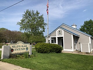
Kelleys Island State Park is a public recreation area occupying one-quarter of Kelleys Island, an island in Lake Erie located 13 miles (21 km) northeast of Port Clinton, Ohio, in the United States. The state park's 677 acres (274 ha) include six miles (9.7 km) of hiking trails, ruins of lime kilns and quarrying operations, sand beach, and campground. The park was established in 1956. The park cooperates with other agencies to manage the adjoining Glacial Grooves State Memorial, a set of rare glacial grooves, North Shore Alvar State Natural Area, a rare alvar habitat, and the North Pond State Nature Preserve, a lake embayment usually separated from the lake by a sand bar.

P. J. Hoffmaster State Park is a public recreation area on the shores of Lake Michigan located five miles north of Grand Haven at the southwest corner of Norton Shores, in Muskegon County, and the northwest corner of Spring Lake Township, in Ottawa County, in the U.S. state of Michigan. It is operated by the Michigan Department of Natural Resources. The state park includes 1,200 acres (490 ha) of land including three miles (4.8 km) of sand beach on the lake.
Laketran is the transit agency that serves Lake County, Ohio, the county northeast of Cleveland. It is the third-largest transit system in Northeast Ohio, serving Mentor, Painesville, Willoughby, Wickliffe. Eastlake, Fairport Harbor, Madison and other Lake County destinations. In 2022, the system had a ridership of 537,000, or about 2,200 per weekday as of the first quarter of 2023.

Ludington State Park is a public recreation area located two miles north of Ludington, Michigan, occupying 5,300 acres (2,100 ha) between the shores of Lake Michigan and Hamlin Lake. The state park is crossed by a one-mile stretch of the Big Sable River and is home to the 112-foot-high (34 m) Big Sable Point Lighthouse, which dates from 1876.
Thompson's Harbor State Park is a remote and largely undeveloped public recreation area on Lake Huron covering 5,109 acres (2,068 ha) in Presque Isle County, Michigan. The state park's seven point five miles (12.1 km) of pristine shoreline encompass a varying terrain of second growth forest, limestone cobble beaches, and deep sand dunes. The park's flora and fauna include a large population of dwarf lake iris as well as more than one hundred bird species, coyotes, deer, and possibly black bear. The park offers six miles (9.7 km) of trails for hikers and cross-country skiers, rustic cabins, and opportunities for sea kayaking. The park was designated a Michigan "dark sky preserve" in 2016.

The Grand River is a tributary of Lake Erie, 102.7 miles (165.3 km) long, in northeastern Ohio in the United States. Via Lake Erie, the Niagara River and Lake Ontario, it is part of the watershed of the St. Lawrence River, which flows to the Atlantic Ocean. It drains an area of 712 mi² (1844 km²).

Painesville Township is one of the five townships of Lake County, Ohio, United States. The population was 20,453 at the 2020 census. It is part of Greater Cleveland in the Northeast Ohio Region, the 15th largest combined statistical area in the United States.

MacKerricher State Park is a state park in California in the United States. It is located 3 miles (4.8 km) north of Fort Bragg in Mendocino County. It covers 9 miles (14 km) of coastline and contains several types of coastal habitat, including beaches, dunes, headlands, coves, wetlands, tide pools, forest, and a freshwater lake.

Black Pond Wildlife Management Area is a 526-acre (213 ha) New York State Wildlife Management Area (WMA) that lies on the eastern shore of Lake Ontario, and at the northern limit of an unusual region of sandy barrier beaches and lagoons. Much of the barrier beach in Black Pond WMA has forested sand dunes that are about 60 feet (18 m) high; these are the highest sand dunes in the northeast United States excepting Cape Cod. Immediately north of the WMA is the 360-acre (150 ha) El Dorado Beach Preserve, which is a bird refuge owned by The Nature Conservancy. North of the outlet from Black Pond to Lake Ontario, the shoreline is a weathered, flat bedrock shelf that is "calcareous" instead of sandy.
Kenny Yuko is an American politician and union activist who served as a member of the Ohio Senate, representing the 25th District. Previously, he was a member of the Ohio House of Representatives, representing the 7th District from 2005 to 2012. Yuko was a political and union activist for more than two decades.

East Harbor State Park is a public recreation area located eight miles (13 km) northwest of Sandusky, Ohio on the shores of Lake Erie. The state park includes beach, campground, marina, and wetland wildlife preserve areas. The park offers swimming, boating and fishing, ten miles (16 km) of multi-use trails, picnicking, hunting, and disc golf.
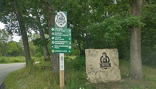
The Hobart Nature District is located in the City of Hobart, Indiana and includes over 1,000 acres (400 ha) of scenic parks, wetlands and floodplains, winding rivers, peaceful lakes, open prairies, oak savannas, old-growth forests, and undulating ravines.


