
The Little Muskingum River is a tributary of the Ohio River, approximately 65 mi (105 km) long, in southeast Ohio in the United States.

Town Creek is a 41.6-mile-long (66.9 km) tributary stream of the Potomac River in the U.S. states of Maryland and Pennsylvania. The creek is formed from the confluence of Sweet Root Creek and Elk Lick Creek, about 0.5 miles (0.8 km) south of Buchanan State Forest in Bedford County, Pennsylvania. Town Creek flows south along the base of Warrior Mountain into Allegany County, Maryland. The Chesapeake and Ohio Canal crosses it at the Town Creek Aqueduct. It empties into the Potomac about 4 miles (6 km) east of Oldtown, Maryland.
The Whitefish River is an 11.9-mile-long (19.2 km) river on the Upper Peninsula of the U.S. state of Michigan. The mouth of the river is in Delta County at 45°54′34″N86°58′01″W on the Little Bay De Noc of Lake Michigan. The main branch of the river is formed by the confluence of the east and west branches at 46°03′25″N86°52′17″W.

Sharpsburg is an unincorporated community in northwestern Bern Township, Athens County, Ohio, United States. There is a convenience store there, with gas pumps, and also containing the post office with the ZIP code 45777. Additionally there is a church, the Bern Township office, and a few houses.
Zaleski State Forest is a state forest in the U.S. state of Ohio, located primarily in Vinton County, with areas in Athens County as well. The 28,000 acre (110 km²) forest surrounds Lake Hope State Park in Vinton County, and borders the Waterloo Wildlife Research Station in Athens County.
Poor Meadow Brook is a 5.8-mile-long (9.3 km) stream within the Taunton River Watershed in southeastern Massachusetts. The stream runs from a wetland near County Street in Hanson to the confluence with the Satucket River in East Bridgewater.
Clifton is an unincorporated community in Ashe County, North Carolina, United States, located east of Fig. It lies at an elevation of 2,769 feet.
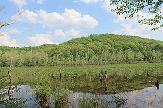
Beaver Creek State Forest is a state forest in Columbiana County, Ohio, United States.
Blue Rock State Forest is a state forest in Muskingum County, Ohio, United States.
Brush Creek State Forest is a state forest in Adams County, Ohio, United States.
Dean State Forest is a state forest in Lawrence County, Ohio, United States.
Sunfish Creek State Forest is a state forest in Monroe County, Ohio, United States.
Tar Hollow State Forest is a state forest in Hocking, Ross, and Vinton counties in the U.S. state of Ohio. It is part of an area of protected land that also includes Tar Hollow State Park.
Yellow Creek State Forest is a state forest in Columbiana County, Ohio, United States.

The Trimble Community Forest or Trimble Township Community Forest is a 1,200-acre (4.9 km2) forest preserve owned by the Appalachia Ohio Alliance, a land trust located in southeast Ohio. Formerly called Taylor Ridge, it was purchased in 2006 from the Sunday Creek Coal Company, and was formerly part of the Sunday Creek State Wildlife Area. The land has a long history of coal, oil, natural gas, and timber production. The AOA negotiated with the Trimble Township Trustees on its use before purchase. It is located in Athens County, Ohio, south of Ohio State Route 78, between Glouster, Ohio and Murray City, Ohio.

The Vinton Furnace State Experimental Forest and Raccoon Ecological Management Area (REMA) is a state forest in Vinton County, Ohio, United States. It comprises 15,849 acres, the largest remaining intact block of forest in Ohio still available for permanent protection. Since 2000, data collected at the forest has been cited in nearly 200 academic articles.
Deep Creek State Forest (DCSF) is a 380-acre state forest 11 miles north of St. Augustine, Florida in St. Johns County, Florida. Deep Creek State Forest is located on both sides of Deep Creek, for which it is named. The state forest is west of the Guana River Wildlife Management Area across the Intracoastal Waterway.
Grandview is an unincorporated community in Washington County, in the U.S. state of Ohio.
Yorktown is an unincorporated community in Tuscarawas County, in the U.S. state of Ohio.

