Vinton County is a county located in the U.S. state of Ohio. As of the 2020 census, the population was 12,800, making it the least populous county in the state. Its county seat is McArthur. The county is named for Samuel Finley Vinton, US Representative from Ohio.

Athens County is a county in southeastern Ohio. As of the 2020 census, the population was 62,431. Its county seat and largest city is Athens. The county was formed in 1805 from Washington County. Because the original state university was founded there in 1804, the town and the county were named for the ancient center of learning, Athens, Greece.
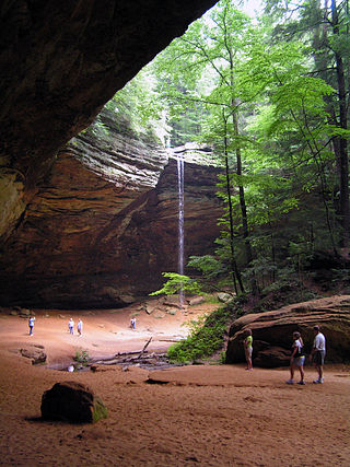
Hocking Hills State Park is a state park in the Hocking Hills region of Hocking County, Ohio, United States. In some areas the park adjoins the Hocking State Forest. Within the park are over 25 miles (40 km) of hiking trails, rock formations, waterfalls, and recess caves. The trails are open from dawn to dusk, all year round, including holidays.
The Hocking Hills is a deeply dissected area of the Allegheny Plateau in Appalachian Ohio, primarily in Hocking County, that features cliffs, gorges, rock shelters, and waterfalls. The relatively extreme topography in this area is due to the Blackhand Sandstone, a particular formation that is thick, hard and weather-resistant, and so forms high cliffs and narrow, deep gorges.

The American Discovery Trail is a system of recreational trails and roads that collectively form a coast-to-coast hiking and biking trail across the mid-tier of the United States. Horses can also be ridden on most of this trail. The coastal trailheads are the Delmarva Peninsula on the Atlantic Ocean and the northern California coast on the Pacific Ocean. The trail has northern and southern alternates for part of its distance, passing through Chicago and St. Louis respectively. The total length of the trail, including both the north and south routes, is 6,800 miles (10,900 km). The northern route covers 4,834 miles (7,780 km) with the southern route covering 5,057 miles (8,138 km). It is the only non-motorized coast-to-coast trail.

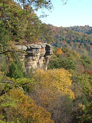
Rockbridge State Nature Preserve is a nature reserve featuring a natural bridge located in the unincorporated community of Rockbridge in Hocking County, Ohio, United States. It is part of the Hocking Hills region, but the sandstone that forms the natural bridge is located lower in the stratigraphic sequence than that which forms most of the region's notable features.
The Hayes Arboretum is an arboretum of 330 acres (130 ha) located in Richmond, Indiana, United States. It is open free to the public Tuesdays through Saturdays, 9:00 A.M. to 5:00 P.M. It is the primary project of the Stanley W. Hayes Research Foundation, a private operating foundation. The Foundation owns a total of 466 acres (189 ha) of property in Wayne County, IN.
Summit Metro Parks is a Metroparks system serving the citizens of Summit County, Ohio by managing 14,000 acres (5,700 ha) in 16 developed parks, six conservation areas and more than 150 miles (240 km) of trails, with 22.4 miles (36.0 km) of the Ohio & Erie Canal Towpath Trail.

The Hockhocking Adena Bikeway, known colloquially as The Bike Path or more formally as The Athens County Bike Path, is a 21-mile (34 km) long bicycle path in Athens County, Ohio, in the United States. The original section of the path was built on a levee along the Hocking River at Ohio University in Athens, on university land. It was gradually expanded and now crosses university land, city land, and county land. The greater part of the path is a rail trail,. The eastern terminus of the path is near the intersection of East State Street with US-50 on the east side of Athens and its western terminus is in Nelsonville, at the Rocky Brands Factory Outlet at the intersection of Canal Street and Myers Street, one block from the Historic Square Arts District.
Gifford State Forest is the smallest state forest in the U.S. state of Ohio. It includes some hiking trails, forested hills and bluffs, and a small breeding nursery. It is located in Bern Township, Athens County. This forest was donated by William Gifford Selby in 1959 and is named after his mother Virginia Gifford.
Erie MetroParks was formed as the "Erie County Metropolitan Park District" in 1968 and adopted its current name in 1991. It consists of 14 individual park areas located throughout Erie County in the US state of Ohio covering approximately 3,200 acres (1,300 ha).

The Lariat Loop National Scenic and Historic Byway is a National Scenic Byway and a Colorado Scenic and Historic Byway located in Jefferson County, Colorado, USA. The byway is a 40-mile (64 km) loop in the Front Range foothills west of Denver through Golden, Lookout Mountain Park, Genesee Park, Evergreen, Morrison, Red Rocks Park, and Dinosaur Ridge. The Lariat Loop connects to the Mount Evans Scenic Byway at Bergen Park.

Pilot Knob State Nature Preserve is located in Powell County, Kentucky, USA. It is a 1,257.93 acre nature preserve in Eastern Kentucky.

The 40-Mile Loop is a partially completed greenway trail around and through Portland in the U.S. state of Oregon. It was proposed in 1903 by the Olmsted Brothers architecture firm as part of the development of Forest Park. One greenway expert calls it "one of the most creative and resourceful greenway projects in the country."

The Akron, OH Metropolitan Statistical Area, sometimes referred to as Greater Akron, is defined by the United States Office of Management and Budget as an area consisting of two counties, Summit and Portage, in Northeast Ohio and anchored by the city of Akron. As of the 2020 census, the MSA had a population of 702,219. The Akron MSA is also part of the larger Cleveland–Akron–Canton, OH Combined Statistical Area, which has a population of 3,633,962 people as of the 2020 census, the largest metropolitan area in Ohio.

Culberson Woods State Nature Preserve is located in Clinton County, Ohio, United States. It protects one of the largest remnants of the white swamp forest which once covered the uplands of the Till Plans of Ohio and Indiana. This type of swamp has poorly drained, white clay soil and is wet in the winter but dry in the summer.
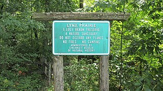
Lynx Prairie is a 52-acre (210,000 m2) nature preserve located in Adams County, Ohio, United States, near the community of Lynx. The preserve features a group of cedar glades which harbor rare prairie species, surrounded by forests on all sides.

Clifton Gorge State Nature Preserve, in Greene County, Ohio, is located three miles east of Yellow Springs, Ohio, and immediately southwest of Clifton, Ohio. The preserve constitutes 268 acres of gorges along two miles of the Little Miami River.