Little Miami Scenic Trail

Last updated • 7 min readFrom Wikipedia, The Free Encyclopedia

Little Miami Scenic Trail
Little Miami Scenic Trail, crossing Little Miami near Xenia, OH.jpg
Little Miami Scenic Trail, crossing the Little Miami River near Xenia, Ohio, May 2018
Length78.1 mi (125.7 km) [1] [2]
LocationSouthwestern Ohio
Designation
Trailheads Springfield to Cincinnati
UseCycling, walking, rollerblading, horseback riding
Elevation change −486  ft (−148  m) [3]
Highest pointSpringfield trailhead
Lowest pointArmleder Park, Cincinnati
DifficultyEasy (fully accessible [4] )
SeasonYear-round
Yellow Springs Station in Greene County Yellow Springs Station.jpg
Yellow Springs Station in Greene County

The Little Miami Scenic Trail is the fourth longest paved trail in the United States, [5] running 78.1 miles (125.7 km) [1] through five southwestern counties in the state of Ohio. The multi-use rail trail sees heavy recreational use by hikers and bicyclists, as well as the occasional horseback rider. Over 700,000 people made use of the trail in 2014. [6]

Contents

Most of the trail runs along the banks of the Little Miami River, in a dedicated, car-free corridor known as Little Miami State Park. This unusually linear state park passes through four counties, with a right-of-way running about 50 miles (80 km) long and averaging 66 feet (20 m) in width [7] for a total of about 400 acres (160 ha). Elsewhere, the corridor ranges from 8 to 10 feet (2.4 to 3.0 m) in width. [8]

The Little Miami Scenic Trail is signposted as State Bike Route 1 south of Xenia and State Bike Route 3 throughout. [9] It is the backbone of a nearly continuous network of paved multi-use trails, centered on the Miami Valley area, that stretches 330 miles (530 km) and connects the Cincinnati, Dayton, and Columbus metropolitan areas. [10] The Little Miami trail is an incrementally growing section of the Buckeye Trail and North Country National Scenic Trail, while the trail south of Xenia also forms the southern leg of the Ohio to Erie Trail and part of U.S. Bicycle Route 21. [11]

History

The largely wooded corridor was created along the right-of-way of the old Little Miami Railroad. The original railway bed is still visible beside the trail in various places along the trail route.

Together with the Ohio Department of Natural Resources, the local governments of Xenia and Yellow Springs purchased land along the abandoned railroad from 1973 to 1983. [12] In 1979, the land became an Ohio State Park. [7] In 1979, ODNR studied developing the corridor as a scenic railroad up to 27.8 miles (44.7 km) long from Loveland to Corwin, as well as a bike trail and bridle trail. However, ODNR prioritized the trails, allowing the bankrupt Penn Central Transportation Company to salvage the rails and ties, which made building new tracks cost-prohibitive. [13] [14] The trail was strongly supported by residents and officials in Loveland, where a park was being developed around the Loveland Bike Trail, but was opposed by residents of Terrace Park, who were concerned about crime. The first 13 miles (21 km) of the trail from Morrow to Loveland was paved in late 1983 [15] [16] and officially opened on May 16, 1984. [17] [18] [19] Two years later, the Ohio Department of Transportation received a grant from the Federal Highway Administration to complete the trail. [12]

By December 20, 1991, [20] the trail officially stretched from Spring Valley in Greene County to the Terrace Park village limit in Hamilton County, across the river from Milford. The trail was extended northward to Xenia later that year [21] and to Springfield in 1998. [22] In 2006, after a protracted, 26-year battle with Terrace Park residents, [23] it was extended southward to Newtown. [24]

Markers for state bike routes 1 and 3 (combined) are posted between Newtown and Xenia. US Bike 1/3 (M1-8).svg
Markers for state bike routes 1 and 3 (combined) are posted between Newtown and Xenia.

In the late 2000s, state budget cuts caused portions of the trail to fall into disrepair, resulting in the temporary closure of some wooden bridges and rest areas. [25] [26] However, an organization called the Friends of the Little Miami State Park Group [27] was founded late 2008 to focus attention and finances on critical portions to keep the trail open and make it safer. Most of the bridges within state park boundaries were paved or re-planked in 2009. In 2010, a failed parks levy prompted the Clark County Park District to indefinitely close its 5.6-mile (9.0 km) stretch of the trail, posting "No Trespassing" signs at park entrances. [28] Because this stretch of trail was partially built with federal funds, the Ohio Department of Natural Resources attempted to force its reopening. [29] [30] The district reopened its parks in April 2011 with volunteer support. [31]

Originally designated State Bike Route 1, [32] [33] [34] the Little Miami Scenic Trail was renumbered in 2011 as State Bike Route 1 south of Xenia and State Bike Route 3 throughout. The concurrency from Newtown to Xenia is marked with "⅓" signs. [9]

In the 2000s, the Adventure Cycling Association and OKI Regional Council proposed designating the Little Miami Scenic Trail as part of U.S. Bicycle Route 25. [35] [36] However, the Ohio Department of Transportation later planned to designate State Bike Route 1, including the Little Miami Scenic Trail south of Xenia, as USBR 21; USBR 25 would instead follow the Great Miami River Recreation Trail to the west. [37] ODOT formally proposed a USBR 21 alignment to the American Association of State Highway and Transportation Officials in spring 2021, which the committee approved. [38] In 2022, a dedicated bridge opened in Cincinnati, spanning the Little Miami River and connecting the trail to other trails toward Downtown Cincinnati. [39]

Current route

The Little Miami Scenic Trail as it approaches the former Peters Cartridge Company factory in Warren County Little Miami Scenic Trail, Peters Cartridge Factory.jpg
The Little Miami Scenic Trail as it approaches the former Peters Cartridge Company factory in Warren County

Xenia made a deal to be the official start of the trail for a donation of land, making the mile markers change from the previous start. For the first 9 miles (14 km) to Xenia, the Little Miami Scenic Trail is operated by the Clark County Park District and the National Trail Parks and Recreation District. [22] From the Simon Kenton Trailhead in Springfield, the Little Miami trail runs southward parallel to U.S. Route 68 and continues to Yellow Springs. Near John Bryan State Park, the North Country Trail and Buckeye Trail enter from Dayton to the west. [11] [40] For the next 15 miles (24 km) to Spring Valley, the Little Miami trail is managed by Greene County. At Xenia Station, it meets the Creekside Trail, as well as the Prairie Grass Trail, on which the Ohio to Erie Trail and U.S. Bicycle Route 21 continue north to Columbus. A short segment of the Little Miami trail that connects the Creekside and Prairie Grass trails is also designated as U.S. Bike Route 50. [41] [42]

Little Miami State Park begins at Hedges Road in Spring Valley, quickly meets the banks of the Little Miami River, and follows U.S. 42 into Warren County. It passes through Corwin (near Waynesville), Caesar Creek State Park, and Oregonia, where the Buckeye Trail rejoins. [40] At Fort Ancient, the trail runs under the imposing Jeremiah Morrow Bridge (Interstate 71). It then passes through the downtown districts of Morrow and South Lebanon to the former Middletown Junction, where the Lebanon Countryside Trail begins.

The Little Miami trail continues southward, opposite the river from Kings Mills and the rear of the expansive Kings Island park grounds. At this location the historic Peters Cartridge Company facility overlooks the bike trail. The trail passes under U.S. 22/State Route 3 at Fosters, across the river from the Landen Mounds. It continues by a few final cornfields before entering Clermont County and downtown Loveland, where it is known as the Loveland Bike Trail.

Loveland Bike Trail in Clermont County Loveland Bike Trail.jpg
Loveland Bike Trail in Clermont County

At Miamiville, the trail crosses to the western, Hamilton County side of the Little Miami River, as it meets State Route 126 (Glendale–Milford Road). The trail passes by Camp Dennison and its former southern terminus in Milford. A 2006 extension carries the Little Miami State Park along U.S. 50 (Wooster Pike) to Avoca Park in Terrace Park. From here, USBR 21, State Bicycle Route 1, and the Loveland section of the Buckeye Trail branch off, following local roads southwest to Cincinnati. A short Great Parks extension leads the Little Miami trail back across the river, beside local roads, to the Little Miami Golf Center in Newtown. [24] The North Country Trail and the Williamsburg section of the Buckeye Trail continue southeast along heavily trafficked roads to Batavia and East Fork State Park. [43]

The Little Miami Scenic Trail continues south another 3.2 miles (5.1 km) from the Little Miami Golf Center south to Clear Creek Park and along State Route 32 to Beechmont Avenue (State Route 125), across from Otto Armleder Memorial Park. [44] Finally, the trail follows a dedicated bridge parallel to Beechmont Avenue over the Little Miami River to the Armleder Trail Connector in Armleder Park, the Lunken Loop around Lunken Field, and the Ohio River Trail westward toward downtown Cincinnati. [45] [46] [47]

Economic effects

Studies in 2008 and 2011 found that single-family residential properties increased in value with increased proximity to the Little Miami Scenic Trail. [48] [49]

See also

Related Research Articles

<span class="mw-page-title-main">Warren County, Ohio</span> County in Ohio, United States

Warren County is a county located in the southwestern part of the U.S. state of Ohio. As of the 2020 census, the population was 242,337. Its county seat is Lebanon and largest city is Mason. The county is one of Ohio's most affluent, with the highest median income of the state's 88 counties. The county was established on May 1, 1803, from Hamilton County; it is named for Dr. Joseph Warren, a hero of the Revolution who sent Paul Revere and the overlooked William Dawes on their famous rides and who died at the Battle of Bunker Hill. Warren County is part of the Cincinnati, OH-KY-IN Metropolitan Statistical Area.

<span class="mw-page-title-main">Loveland, Ohio</span> City in Hamilton, Clermont, and Warren counties in Ohio, United States

Loveland is a city in Hamilton, Clermont, and Warren counties in the southwestern part of the U.S. state of Ohio. The population was 13,307 at the 2020 census. Considered part of the Cincinnati metropolitan area, Loveland is located near exit 52 off Interstate 275, about 15 miles (24 km) northeast of the Cincinnati city limits. It borders Symmes, Miami and Hamilton townships and straddles the Little Miami River. Once a busy railroad town, Loveland is now a major stop along the Little Miami Scenic Trail.

<span class="mw-page-title-main">North Country Trail</span> Long-distance hiking trail in the US

The North Country Trail is a long-distance hiking trail in the Midwestern and Northeastern United States. The trail extends roughly 4,800 miles (7,700 km) from Lake Sakakawea State Park in North Dakota to the Appalachian Trail in Green Mountain National Forest in Vermont, passing through eight states along its route. As of 2023, most of the trail is in place, though about one-third of the distance consists of road walking; those segments are frequently evaluated for transfer to off-road segments on nearby public or private lands.

The Buckeye Trail is a 1,444-mile (2,324 km) hiking trail and long-distance trail that loops around the state of Ohio. Part of it is on roads and part is on wooded trail. Road portions of the trail are gradually being relocated to separate trail.

<span class="mw-page-title-main">Little Miami River</span> River in the United States of America

The Little Miami River is a Class I tributary of the Ohio River that flows 111 miles (179 km) through five counties in southwestern Ohio in the United States. The Little Miami joins the Ohio River east of Cincinnati. It forms parts of the borders between Hamilton and Clermont counties and between Hamilton and Warren counties. The Little Miami River is one of 156 American rivers designated by the U.S. Congress or the Secretary of the Interior as a National Wild and Scenic River and lends its name to the adjacent Little Miami Scenic Trail.

<span class="mw-page-title-main">American Discovery Trail</span> Long-distance hiking trail across the United States

The American Discovery Trail is a system of recreational trails and roads that collectively form a coast-to-coast hiking and biking trail across the mid-tier of the United States. Horses can also be ridden on most of this trail. The coastal trailheads are the Delmarva Peninsula on the Atlantic Ocean and the northern California coast on the Pacific Ocean. The trail has northern and southern alternates for part of its distance, passing through Chicago and St. Louis respectively. The total length of the trail, including both the north and south routes, is 6,800 miles (10,900 km). The northern route covers 4,834 miles (7,780 km) with the southern route covering 5,057 miles (8,138 km). It is the only non-motorized coast-to-coast trail.

The Little Miami Railroad was a railway of southwestern Ohio, running from the eastern side of Cincinnati to Springfield, Ohio. By merging with the Columbus and Xenia Railroad in 1853, it created the first through-rail route from the important manufacturing city of Cincinnati to the state capital, Columbus. In this period, railroads were important for creating connections between the important waterways of the Great Lakes and the Ohio River, which were major transportation routes for products to other markets.

<span class="mw-page-title-main">Hamilton Township, Warren County, Ohio</span> Township in Ohio, United States

Hamilton Township is one of the eleven townships of Warren County, Ohio, United States. It is located in the south central portion of the county. The population was 30,587 at the 2020 census.

<span class="mw-page-title-main">Loveland Bike Trail</span> Bike trail in Southwest Ohio

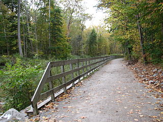
The Loveland Bike Trail is a rail trail in Ohio. It is a section of the Little Miami Scenic Trail within the Loveland, Ohio city limits in Clermont County. Like most of the longer trail, it was built along the right-of-way of the abandoned Little Miami Railroad, on the Little Miami River. Along with 15 other city parks, the trail corridor is maintained by City of Loveland Recreation Commission. The trail was opened in the 1980s and became part of the Little Miami Scenic Trail in 1984. More than 100,000 people accessed the Little Miami Scenic Trail via the Loveland trailhead in 2014.

<span class="mw-page-title-main">Lebanon Countryside Trail</span> Rail trail in Ohio

The Lebanon Countryside Trail is a rail trail in Ohio.

<span class="mw-page-title-main">Ohio State Route 73</span> State highway in southern Ohio, US

State Route 73 is an east–west state highway in the southern portion of the U.S. state of Ohio. Its western terminus is on U.S. Route 27 in Oxford at the intersection of SR 732. SR 73’s eastern terminus is in Portsmouth at US 23; this is also the southern terminus of SR 104, and the two state routes run concurrently for over 6 miles (9.7 km) from this point north. Once SR 73 enters Scioto County, it is designated as the Scenic Scioto Heritage Trail by the Ohio Department of Transportation.

<span class="mw-page-title-main">Ohio to Erie Trail</span>

The Ohio to Erie Trail is a dedicated multi-use trail crossing Ohio from southwest to northeast, crossing 326 mi (525 km) of regional parks, nature preserves, and rural woodland.

<span class="mw-page-title-main">Xenia Station</span> Railway station in Ohio, the United States of America

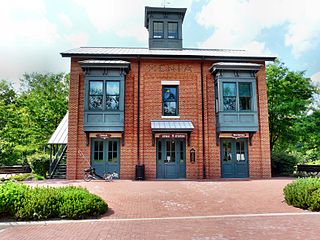
Xenia Station, located at 150 Miami Avenue in Xenia, Ohio, in the United States, is a replica of Xenia's 1880s brick railroad station.

<span class="mw-page-title-main">Cycling in Minnesota</span>

Cycling in Minnesota is a popular form of recreation, commuting, and competitive sport that has grown in prominence over the years. It has been a popular activity in the state since the late 19th century.

<span class="mw-page-title-main">Mississippi River Trail</span> Long-distance bicycle route

The Mississippi River Trail is a designated bicycle and pedestrian trail that traverses the shores of the Mississippi River in the United States. The trail extends from the headwaters at Lake Itasca in Minnesota to near the mouth of the river in Venice, Louisiana. Much of the trail’s 3,000 miles (4,800 km) follows roadways used by motor vehicles, although some of the route is on multi-use trails. The segment in Minnesota has been designated as U.S. Bicycle Route 45, part of the U.S. Bicycle Route System.

U.S. Bicycle Route 50 (USBR 50) is a planned east–west cross country U.S. Bicycle Route that currently consists of two discontiguous sections: a western section between San Francisco and Border, Utah, and an eastern section between Terre Haute, Indiana, and Washington, D.C.

This is a list of high school athletic conferences in the Southwest Region of Ohio, as defined by the OHSAA. Because the names of localities and their corresponding high schools do not always match and because there is often a possibility of ambiguity with respect to either the name of a locality or the name of a high school, the following table gives both in every case, with the locality name first, in plain type, and the high school name second in boldface type. The school's team nickname is given last.

This is a list of former high school athletic conferences in the Southwest Region of Ohio, as designated by the Ohio High School Athletic Association. If a conference had members that span multiple regions, the conference is placed in the article of the region most of its former members hail from. Because the names of localities and their corresponding high schools do not always match and because there is often a possibility of ambiguity with respect to either the name of a locality or the name of a high school, the following table gives both in every case, with the locality name first, in plain type, and the high school name second in boldface type. The school's team nickname is given last.

U.S. Bicycle Route 21 (USBR 21) is a north–south United States Bicycle Route that travels through Ohio, Kentucky, Tennessee, and Georgia in the United States.

U.S. Bicycle Route 81 (USBR 81) is a United States Bicycle Route in the state of Washington. It is planned to travel north–south along the eastern edge of the state from Asotin to the Canadian border near Metaline Falls. The section from Asotin to Clarkston and Tekoa, spanning 103.5 miles (166.6 km), was designated in 2021. USBR 81 also has a child route, USBR 281, that was designated in 2021 and follows U.S. Route 195.

References

  1. 1 2 "Little Miami Bike Trail expanding, putting it closer to downtown Cincinnati - Cincinnati Business Courier". Cincinnati Business Courier. Retrieved March 18, 2016.
  2. "Little Miami Scenic Trail". Ohio Bikeways. Retrieved March 20, 2015.
  3. Recktenwalt, Thomas J. (November 16, 2008). "Little Miami Scenic Trail". Miami Valley RailTrails. Archived from the original on February 4, 2012. Retrieved November 17, 2008.
  4. Menke, Bill (August 1996). "Standards for Trail Construction" (PDF). North Country National Scenic Trail: A Handbook for Trail Design, Construction and Maintenance (PDF). National Park Service . Retrieved February 6, 2009.
  5. "Longest trails: longest paved trail and longest ice skating trail". American Trails. June 28, 2013. Archived from the original on July 4, 2008. Retrieved September 27, 2015.
  6. Lee, Marika (May 13, 2015). "Improvements coming for the Little Miami State Park". The Loveland Herald. Gannett Company. The Community Press. Retrieved September 27, 2015.
  7. 1 2 "Little Miami State Park". Ohio State Parks. Ohio Department of Natural Resources. 2008. Retrieved November 18, 2008.
  8. "Little Miami Scenic Trail". Trails From Rails. November 16, 2008. Archived from the original on January 27, 2009. Retrieved January 18, 2009.
  9. 1 2 Billiter, James (April 8, 2013). "1/3 as important as a car?". Jimmy Road Rash luvs Bjet. Retrieved June 1, 2012.
  10. McCall, Ken R. (June 11, 2015). "Do we have the nation's largest paved trail network?". Dayton.com. Cox Media Group . Retrieved September 27, 2015.
  11. 1 2 Boyd, Wes (December 12, 2003). "Ohio: Heart of the North Country Trail". Following the North Country Trail (3rd ed.). Lowell, Michigan: North Country Trail Association. Archived from the original on February 25, 2009. Retrieved November 22, 2008.
  12. 1 2 "Little Miami Scenic Trail". YellowSprings.com. June 11, 2006. Archived from the original on February 8, 2009. Retrieved January 18, 2009.
  13. Kaufman, Ben L. (February 9, 1979). "Little Miami Rail Plan Could Be In Jeopardy". The Cincinnati Enquirer. p. C-2 via Newspapers.com.
  14. Kaufman, Ben L. (April 20, 1979). "Little Miami RR In Five Of Six Plans ODNR Considering". The Cincinnati Enquirer . p. B-6 via Newspapers.com.
  15. Agin, Mike (December 8, 1983). "Trail may pave way to economic success". The Cincinnati Post (Tri-County ed.). p. 1B via Newspapers.com.
  16. Rosen, Steven (May 8, 1983). "Loveland Happy About Bike Trail". The Cincinnati Enquirer. p. C-1 via Newspapers.com.
  17. Agin, Mike (May 17, 1984). "Little Miami trail officially opened". The Cincinnati Post. p. 14B via Newspapers.com.
  18. City of Loveland (September 28, 2004). "Amendment and Addition to the City of Loveland Downtown Historic Redevelopment Plan". Historic Downtown Loveland Request For Proposals. Archived from the original (Word) on July 4, 2007. Retrieved May 28, 2007.
  19. Cutter, John A. (August 14, 1989). "Backers say trails lead to prosperity". North Pinellas Times (St. Petersburg Times). St. Petersburg, Florida. p. 1. Retrieved January 18, 2009. Morrow sits at the start of the Little Miami Scenic Park trail, a 13-mile recreational path.
  20. Haidet, Janice (July 22, 1992). "Stop Means Stop, Even on Greene Bike Path" (fee required). Dayton Daily News . Dayton, Ohio. p. Z6-1. Retrieved January 18, 2009. There have been relatively few problems on the bikeway since it was officially dedicated Dec. 20, Schneider said.
  21. Editorial board (December 5, 1991). "From Dayton to Xenia and Beyond, Congress Offered Right Connection" (fee required). Dayton Daily News. Dayton, Ohio. p. 14A. Retrieved January 18, 2009. The Yellow Springs-to-Xenia portion of the Little Miami trail was paved in the fall.
  22. 1 2 "Trails". National Trail Parks And Recreation District. August 19, 2008.
  23. Edwards, Jennifer (March 1, 2004). "Trail's happy median sought". The Cincinnati Enquirer . Retrieved November 16, 2008.
  24. 1 2 "Governor Taft Cuts Ribbon on Little Miami Scenic Trail Extension in Hamilton County" (Press release). Ohio Department of Natural Resources. June 10, 2006. Retrieved November 16, 2008.
  25. Whitaker, Carrie (November 11, 2008). "Unsafe conditions on bike trail". The Cincinnati Enquirer. Retrieved November 16, 2008.
  26. McCall, Ken (October 31, 2008). "Little Miami Scenic Trail needs help from its friends". Dayton Daily News. Retrieved November 16, 2008.
  27. "Home - Friends of the Little Miami State Park". flmsp.org. Retrieved January 14, 2022.
  28. Sweigart, Josh (November 13, 2010). "County parks, bike paths to close indefinitely". Dayton Daily News . Retrieved December 12, 2010.
  29. Shows, Lauren (November 29, 2010). "State orders re-opening of bike path". The Yellow Springs News. Yellow Springs, Ohio. Retrieved December 26, 2010.
  30. "McGregor Gets Involved in Park Dispute". New Carlisle News. New Carlisle, Ohio. December 9, 2010. Retrieved December 26, 2010.
  31. Sweigart, Josh (February 7, 2011). "Board votes to reopen parks". Springfield News-Sun . Springfield, Ohio. Retrieved February 15, 2011.
  32. Recktenwalt, Thomas J. (November 16, 2008). "About Multi-Use Trail Names and Route Numbers". Miami Valley RailTrails. Archived from the original on December 31, 2008. Retrieved November 17, 2008.
  33. Greene County Greene Ways (PDF) (Map). City of Xenia, Ohio. Archived from the original (PDF) on December 11, 2009. Retrieved November 16, 2008. Available at the Xenia Station kiosk.
  34. Recktenwalt, Thomas J. (January 2011). "Miami Valley RailTrails Newsletter, January 2011". Miami Valley RailTrails. Archived from the original on July 19, 2011. Retrieved February 1, 2011.
  35. "2 Digit Number Designation" (PDF). Missoula, Montana: Adventure Cycling Association. December 3, 2008. Archived from the original (PDF) on December 27, 2009. Retrieved January 10, 2009.
  36. "Status Report on Trails and Greenways in the OKI Region" (PDF). Ohio-Kentucky-Indiana Regional Council of Governments. January 30, 2011. p. 16. Retrieved November 6, 2011.
  37. "State & US Bike Route System: Overview and Implementation" (PDF). Ohio Department of Transportation. August 3, 2020. p. 2. Retrieved April 19, 2021.
  38. "Ohio's State and US Bike Routes". Ohio Department of Transportation. March 1, 2021. Retrieved April 20, 2021.
  39. "A new state joins the USBRS!" (Press release). Missoula, Montana: Adventure Cycling Association. November 30, 2022. Retrieved December 1, 2022.
  40. 1 2 "Caesar Creek Section". Buckeye Trail Association. February 7, 2007. Archived from the original on October 6, 2008. Retrieved November 22, 2008.
  41. Vitale, Marty (May 29, 2014). "Report to SCOH". Louisville, Kentucky: Special Committee on U.S. Route Numbering, American Association of State Highway and Transportation Officials. Archived from the original (Office Open XML) on May 31, 2014. Retrieved June 1, 2014.
  42. Townley, Jennifer (April 10, 2014). "USBR 50 update" (PDF). Ohio Department of Transportation . Retrieved June 1, 2014.
  43. "Williamsburg Section". Buckeye Trail Association. February 7, 2007. Archived from the original on October 6, 2008. Retrieved November 22, 2008.
  44. Vilvens, Sheila (July 9, 2015). "Scenic Trail extension brings Cincy connection in reach". The Community Press. Gannett Company. Retrieved September 1, 2015.
  45. "www.cincinnati-oh.gov/bikes/bike-maps/ohio-river-trail-map/". cincinnati-oh.gov. Retrieved January 14, 2022.
  46. "Lunken Airport Trail". littlemiamitrail.com. Retrieved January 14, 2022.
  47. "Beechmont Bridge Connection Project". Great Parks of Hamilton County. Retrieved December 5, 2021.
  48. Karadeniz, Duygu (2008). The Impact of the Little Miami Scenic Trail on Single Family Residential Property Values (PDF) (Master of Community Planning thesis thesis). University of Cincinnati College of Design, Architecture, Art, and Planning . Retrieved September 27, 2015.
  49. Fuller, Dawn (October 11, 2011). "New Research Finds that Homeowners and City Planners Should 'Hit the Trail' When Considering Property Values" (Press release). University of Cincinnati . Retrieved September 27, 2015.

Further reading

39°48′26″N83°53′17″W / 39.80723°N 83.88795°W / 39.80723; -83.88795