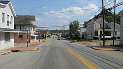
Williamsburg, Ohio | |
---|---|
Coordinates: 39°03′20″N84°02′52″W / 39.05556°N 84.04778°W | |
Country | United States |
State | Ohio |
County | Clermont |
Township | Williamsburg |
Government | |
• Mayor | Mary Ann Lefker[ citation needed ] |
Area | |
• Total | 2.59 sq mi (6.72 km2) |
• Land | 2.56 sq mi (6.63 km2) |
• Water | 0.04 sq mi (0.09 km2) |
Elevation | 791 ft (241 m) |
Population (2020) | |
• Total | 2,570 |
• Density | 1,004.30/sq mi (387.77/km2) |
Time zone | UTC-5 (Eastern (EST)) |
• Summer (DST) | UTC-4 (EDT) |
ZIP code | 45176 |
Area code | 513 |
FIPS code | 39-85288 |
GNIS feature ID | 2400171 [2] |
Website | http://www.williamsburgohio.org/ |
Williamsburg is a village in Clermont County, Ohio, United States. The population was 2,570 at the 2020 census.
Williamsburg was founded in 1796 by General William Lytle of the prominent Lytle family of Cincinnati. [3] The village was named after the city of Williamsburg, Virginia. [4] A post office called Williamsburgh was established in 1802, and the name was changed to Williamsburg in 1893. [5]
According to the United States Census Bureau, the village has a total area of 1.97 square miles (5.10 km2), of which 1.95 square miles (5.05 km2) is land and 0.02 square miles (0.05 km2) is water. [6]
Census | Pop. | Note | %± |
---|---|---|---|
1820 | 177 | — | |
1830 | 286 | 61.6% | |
1840 | 385 | 34.6% | |
1860 | 555 | — | |
1870 | 773 | 39.3% | |
1880 | 795 | 2.8% | |
1890 | 828 | 4.2% | |
1900 | 1,002 | 21.0% | |
1910 | 948 | −5.4% | |
1920 | 969 | 2.2% | |
1930 | 1,147 | 18.4% | |
1940 | 1,194 | 4.1% | |
1950 | 1,490 | 24.8% | |
1960 | 1,956 | 31.3% | |
1970 | 2,054 | 5.0% | |
1980 | 1,952 | −5.0% | |
1990 | 2,322 | 19.0% | |
2000 | 2,358 | 1.6% | |
2010 | 2,490 | 5.6% | |
2020 | 2,570 | 3.2% | |
U.S. Decennial Census [7] |
As of the census [8] of 2010, there were 2,490 people, 990 households, and 634 families living in the village. The population density was 1,276.9 inhabitants per square mile (493.0/km2). There were 1,102 housing units at an average density of 565.1 per square mile (218.2/km2). The racial makeup of the village was 98.0% White, 0.5% African American, 0.2% Native American, 0.1% Asian, 0.2% from other races, and 1.0% from two or more races. Hispanic or Latino of any race were 0.5% of the population.
There were 990 households, of which 36.3% had children under the age of 18 living with them, 42.5% were married couples living together, 15.8% had a female householder with no husband present, 5.8% had a male householder with no wife present, and 36.0% were non-families. 31.5% of all households were made up of individuals, and 11.6% had someone living alone who was 65 years of age or older. The average household size was 2.46 and the average family size was 3.05.
The median age in the village was 36.6 years. 26.7% of residents were under the age of 18; 8.9% were between the ages of 18 and 24; 26.9% were from 25 to 44; 25.6% were from 45 to 64; and 11.8% were 65 years of age or older. The gender makeup of the village was 48.4% male and 51.6% female.
As of the census [9] of 2000, there were 2,358 people, 927 households, and 620 families living in the village. The population density was 1,235.6 inhabitants per square mile (477.1/km2). There were 1,023 housing units at an average density of 536.0 per square mile (207.0/km2). The racial makeup of the village was 98.69% White, 0.17% African American, 0.34% Native American, 0.08% Asian, 0.08% from other races, and 0.64% from two or more races. Hispanic or Latino of any race were 0.17% of the population.
There were 927 households, out of which 35.5% had children under the age of 18 living with them, 48.8% were married couples living together, 13.4% had a female householder with no husband present, and 33.1% were non-families. 26.8% of all households were made up of individuals, and 10.6% had someone living alone who was 65 years of age or older. The average household size was 2.50 and the average family size was 3.05.
In the village, the population was spread out, with 27.2% under the age of 18, 9.7% from 18 to 24, 31.9% from 25 to 44, 20.4% from 45 to 64, and 10.9% who were 65 years of age or older. The median age was 33 years. For every 100 females there were 88.2 males. For every 100 females age 18 and over, there were 85.4 males.
The median income for a household in the village was $37,115, and the median income for a family was $46,528. Males had a median income of $35,395 versus $24,455 for females. The per capita income for the village was $17,250. About 8.0% of families and 11.3% of the population were below the poverty line, including 15.8% of those under age 18 and 16.3% of those age 65 or over.
Williamsburg has a public library, a branch of the Clermont County Public Library. [10]
Aberdeen is a village in Huntington Township, Brown County, Ohio, United States, along the Ohio River 50 miles (80 km) southeast of Cincinnati. The population was 1,515 at the 2020 census.
Batavia is a village in and the county seat of Clermont County, Ohio, United States. The population was 1,972 at the 2020 census. It is part of the Cincinnati metropolitan area.
Bethel is a village in Tate Township, Clermont County, Ohio, United States. The population was 2,620 at the 2020 census.
Chilo or is a village in Clermont County, Ohio, United States, along the Ohio River. The population was 71 at the 2020 census.
Day Heights is a census-designated place (CDP) in Clermont County, Ohio, United States. The population was 2,625 at the 2020 census.
Felicity is a village in Franklin Township, Clermont County, Ohio, United States. The population was 651 at the 2020 census.
Moscow is a village in Clermont County, Ohio. The population was 155 at the time of the 2020 census. The William H. Zimmer Power Station, a coal-fired power plant that was converted from a planned nuclear power plant during construction, is partially located within village limits. It is located near the Ulysses S. Grant Birthplace.
Mount Repose is a census-designated place (CDP) in Miami Township, Clermont County, Ohio, United States. The population was 4,648 at the 2020 census.
Mulberry is a census-designated place (CDP) in Miami Township, Clermont County, Ohio, United States. The population was 3,459 at the 2020 census.
Neville is a village in Clermont County, Ohio, United States, along the Ohio River. The population was 87 at the 2020 census.
Newtonsville is an unincorporated community and former village in Clermont County, Ohio, United States. The population was 392 at the 2010 census. In 2019, residents voted to dissolve the village.
Owensville is a village in Clermont County, Ohio, United States. The population was 786 at the 2020 census.
Summerside is a census-designated place (CDP) in Union Township, Clermont County, Ohio, United States. Its population was 4,941 as of the 2020 census.
Withamsville is a census-designated place (CDP) in Pierce and Union townships of Clermont County, Ohio, United States. The population was 7,357 at the 2020 census.
Millersport is a village in Fairfield County, Ohio, United States. The population was 978 at the 2020 census. Millersport is most notable as the home of the Sweet Corn Festival, which is held in Millersport annually during the first week of September.
Addyston is a village in Miami Township, Hamilton County, Ohio, United States. Located along the Ohio River, it is a western suburb of the neighboring city of Cincinnati. The population was 927 at the 2020 census.
Martinsburg is a village in Knox County, Ohio, United States. The population was 222 at the 2020 census.
Batesville is a village in Noble County, Ohio, United States. The population was 101 at the 2020 census. Batesville was originally called Williamsburg, and under the latter name was laid out in 1827.
Milford is a city in Clermont and Hamilton counties in the U.S. state of Ohio. Milford is the westernmost city in Appalachian Ohio, and located along the Little Miami River and its East Fork in the southwestern part of the state, it is a part of the Cincinnati metropolitan area. The population was 6,582 at the 2020 census.
Gratiot is a village in Licking and Muskingum counties in the U.S. state of Ohio. The population was 215 at the 2020 census.