Related Research Articles

Grandview is a census-designated place (CDP) in Hamilton County, Ohio, United States. The population was 1,312 at the 2020 census.
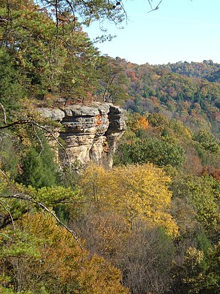
The Hocking Hills is a deeply dissected area of the Allegheny Plateau in Appalachian Ohio, primarily in Hocking County, that features cliffs, gorges, rock shelters, and waterfalls. The relatively extreme topography in this area is due to the Blackhand Sandstone, a particular formation that is thick, hard and weather-resistant, and so forms high cliffs and narrow, deep gorges.

Marie J. Desonier State Nature Preserve is located in eastern Athens County, Ohio, United States. It is heavily forested, on Jordan Run near its headwaters, in Deep Hollow. The preserve features a loop trail, the Oak Ridge Trail, with two footbridges. This trail can be hiked in a two-mile loop, or as a 2.5-mile loop. There are no other developed facilities there except for a small parking area. The preserve represents a good example of the local forest, with relatively few invasive species.
Oregonia is an unincorporated community in northwestern Washington Township, Warren County, Ohio, United States, on the east shore of the Little Miami River about five miles northeast of Lebanon and six miles south of Waynesville. The ZIP Code for Oregonia is 45054.

The Lebanon Countryside Trail is a rail trail in Ohio.
Gifford State Forest is the smallest state forest in the U.S. state of Ohio. It includes some hiking trails, forested hills and bluffs, and a small breeding nursery. It is located in Bern Township, Athens County. This forest was donated by William Gifford Selby in 1959 and is named after his mother Virginia Gifford.

Mount Lookout, Ohio is one of the Eastern neighborhoods of Cincinnati, just northwest of Linwood and overlooking the Ohio River valley.
Spring Gulch is a cross-country ski area located on Thompson Creek Road in northwestern Pitkin County, Colorado, six miles west of Carbondale, Colorado, USA. The ski area shares its name with a historical 19th and early 20th century coal mining townsite, Spring Gulch, which is in the vicinity mostly to the south of the ski area proper. The area is run by the non-profit Mount Sopris Nordic Council for the benefit of community members and visitors. Use of the area is free of cost and limited to cross-country skiing activities.
Miamiville is an unincorporated community and census-designated place (CDP) in western Miami Township, Clermont County, Ohio, United States, along the Little Miami River and the Loveland Bike Trail. It had a population of 205 at the 2020 census. It has a post office with the ZIP code 45147.

Westwood is an urban-suburban neighborhood of Cincinnati, Ohio. It is located north of Price Hill, west of Fairmount, and southwest of Mount Airy.

Sheridan State Scenic Corridor is a state park in the Columbia River Gorge, west of Cascade Locks, Oregon. The 11-acre (4.5 ha) property, containing an old-growth forest, is located on the south side of Interstate 84 at approximately milepoint 42.5, and was not accessible by motor vehicle since I-84 was built in 1960. However, with the opening of the Eagle Creek-Cascade Locks segment of the Historic Columbia River Highway State Trail in 1998, it has become easily accessible by foot or bicycle. The park is on a triangular lot, surrounded by I-84 and the Mount Hood National Forest.

Mount Airy is a neighborhood in Cincinnati, Ohio, United States. The population was 9,210 at the 2020 census. Interstate 74's Ohio-Iowa segment ends in Mount Airy, OH, while the westernmost North Carolina segment ends in Mount Airy, NC.
Scioto Trail State Forest is a state forest in Pike and Ross counties in the U.S. state of Ohio. Scioto Trail State Park lies within the state forest.
New Burlington is a census-designated place (CDP) in Springfield Township, Hamilton County, Ohio, United States. The population was 5,049 at the 2020 census.

Miami Whitewater Forest is the largest park in the Great Parks of Hamilton County with 4,345 acres (17.58 km2). It is located in Hamilton County, Ohio, just northwest of Cincinnati. Included in the park are the 7.8-mile (12.6 km) paved Shaker Trace Trail as well as many other shorter trails. There is also a golf course, a 46-acre (19 ha) campground, horseback riding, and many sports offered. 46 modern campsites are available, with electric hookups and a fire pit.
Archers Fork is an unincorporated community in Washington County, in the U.S. state of Ohio.
Mount Holly is an unincorporated community in Clermont County, in the U.S. state of Ohio.
Mount Holly is an unincorporated community in Warren County, in the U.S. state of Ohio.
Mount Carmel Heights is an unincorporated community located in Clermont County, Ohio, United States.
Mount Saint John is an unincorporated community located in Greene County, Ohio, United States.
References
Municipalities and communities of Clermont County, Ohio, United States | ||
|---|---|---|
| Cities |  | |
| Villages | ||
| Townships | ||
| CDPs | ||
| Unincorporated communities |
| |
| Footnotes | ‡This populated place also has portions in an adjacent county or counties | |
39°05′57″N84°17′58″W / 39.09917°N 84.29944°W
| | This Clermont County, Ohio state location article is a stub. You can help Wikipedia by expanding it. |