
Knox County is a county located in the U.S. state of Ohio. As of the 2020 census, the population was 62,721. Its county seat is Mount Vernon. The county is named for Henry Knox, an officer in the American Revolutionary War who was later the first Secretary of War. Knox County comprises the Mount Vernon, OH Micropolitan Statistical Area, which is also included in the Columbus-Marion-Zanesville, OH Combined Statistical Area.

Gambier is a village in Knox County, Ohio, United States. The population was 2,213 at the 2020 census.

Mount Vernon is a city in and the county seat of Knox County, Ohio, United States, along the Kokosing River. It is located 40 miles (64 km) northeast of Columbus. The population was 16,956 at the 2020 census.

The Wilderness Road was one of two principal routes used by colonial and early national era settlers to reach Kentucky from the East. Although this road goes through the Cumberland Gap into southern Kentucky and northern Tennessee, the other is sometimes called the "Cumberland Road" because it started in Fort Cumberland in Maryland. Despite Kentucky Senator Henry Clay's advocacy of this route, early in the 19th century, the northern route was selected for the National Road, connecting near Washington, Pennsylvania into the Ohio Valley of northern Kentucky and Ohio.
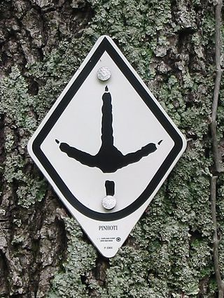
The Pinhoti Trail is a Southern Appalachian Mountains long-distance trail, 335 miles (540 km) in length, located in the United States within the states of Alabama and Georgia. The trail's southern terminus is on Flagg Mountain, near Weogufka, Alabama, the southernmost peak in the state that rises over 1,000 feet (300 m). The trail's northern terminus is where it joins the Benton MacKaye Trail. The trail's highest point is Buddy Cove Gap, with an elevation of 3164 feet near the Cohutta Wilderness. Its lowest point above sea level is close to Weogufka Creek near Weogufka State Forest at 545 feet.

The Mount Vernon Trail (MVT) is an 18-mile (29 km) long shared use path that travels along the George Washington Memorial Parkway in Northern Virginia between Rosslyn and George Washington's home at Mount Vernon. The trail connects the easternmost portions of Arlington County, the City of Alexandria, and Fairfax County, and travels mostly on dedicated trail with a small portion on city streets. As part of U.S. Bike Route 1, the Potomac Heritage Trail and the East Coast Greenway, the MVT opened in April 1972 as a gravel path and was subsequently expanded and paved.

The Kokosing River (ko-KO-sing) is a tributary of the Walhonding River, 57.2 miles (92.1 km) long, in east-central Ohio in the United States. Via the Walhonding, Muskingum and Ohio Rivers, it is part of the watershed of the Mississippi River, draining an area of 482 square miles (1248 km2). Etymologically, "Kokosing" translates roughly to "River of Little Owls." The Kokosing River rises in Morrow County, northeast of Mount Gilead, and initially flows southwardly. It turns eastwardly near Chesterville and flows through Knox and Coshocton Counties, passing the communities of Mount Vernon, Gambier and Howard. In western Coshocton County the Kokosing joins the Mohican River to form the Walhonding River, about 2 miles (3 km) northwest of Nellie.
Ramser Arboretum is an arboretum at the intersection of Ohio State Route 3 and Ohio State Route 205 in Danville, Ohio. Although privately owned, the arboretum is open to the public year-round except for deer-hunting season.

Maryland Route 144 is a collection of state highways in the U.S. state of Maryland. These highways are sections of old alignment of U.S. Route 40 between Cumberland and Baltimore. Along with US 40 Scenic, US 40 Alternate, and a few sections of county-maintained highway, MD 144 is assigned to what was once the main highway between the two cities, connecting those endpoints with Hancock, Hagerstown, Frederick, New Market, Mount Airy, Ellicott City, and Catonsville. MD 144 has seven disjoint sections of mainline highway that pass through the Appalachian Mountains in Allegany and Washington counties and the rolling Piedmont of Frederick, Carroll, Howard, and Baltimore counties.

The Perkiomen Trail is a 19-mile-long (31 km) multi-use rail trail along the Perkiomen Creek in Pennsylvania.
The Walhonding Canal was a canal in Coshocton County, Ohio that was used as a feeder canal for the Ohio and Erie Canal. A small canal, at only 25 miles (40.2 km) long, it was wholly contained within Coshocton County, following the Mohican River from Cavallo south to the confluence with the Kokosing River, which together with the Mohican forms the Walhonding River. The canal followed the Walhonding River southeast toward Coshocton where it met the Ohio and Erie Canal in Roscoe Village.
The Ohio to Erie Trail is a dedicated multi-use trail crossing Ohio from southwest to northeast, crossing 326 mi (525 km) of regional parks, nature preserves, and rural woodland.

The Pere Marquette State Trail is a bicycle and multi-use trail in lower Michigan, running 55 miles (89 km) through Clare, Lake, and Osceola Counties. Intersecting with the White Pine Trail in Reed City, the trail is paved in areas, with a ballast or cinder surface elsewhere. The trail's western terminus is the Village of Baldwin with the City of Clare as its eastern terminus. From Baldwin east to The Pere Marquette State Trail is open to non-motorized uses. Except for a gap at its eastern end as the trail enters the City of Clare, it is developed on a former railroad bed. From the City of Clare southeast to Midland, the trail continues as the Pere Marquette Rail Trail.

The Bridge of Dreams is a 370-foot covered bridge located near Brinkhaven, Ohio. Originally built in the 1920s as a railroad bridge, and covered in 1998. It is the second longest covered bridge in Ohio after the Smolen–Gulf Bridge, and third longest covered bridge in the United States.
Root River State Trail and Harmony-Preston State Trail are a 60-mile (97 km) paved multi-use rail trail system in the driftless area of southeast Minnesota. The trail system consists of two main segments, the Root River segment, and Harmony-Preston Valley segment. The trails are used mainly for bicycling, hiking, and inline skating in the summer, and for cross country skiing in the winter. Much of the trail, especially the Root River segment, is built along a former Milwaukee Road railbed following the contours of the Root River valley. The trail was originally paved in the 1980s, and repaved by June 2008.

State Route 308 is a north–south state highway in the central portion of Ohio, a U.S. state. The southern terminus of SR 308 is at SR 229 in the western end of the village of Gambier, and its northern terminus is three miles (4.8 km) to the north of that point at a T-intersection with U.S. Route 36 (US 36) that is located approximately one and a half miles (2.4 km) east of the city limits of Mount Vernon.

The Four Mile Run Trail is a 7-mile long, paved shared use path in Arlington County and Falls Church. It runs along Four Mile Run from Benjamin Banneker Park in Falls Church to the Mount Vernon Trail near Ronald Reagan Washington National Airport, where Four Mile Run empties into the Potomac River. The trail runs roughly parallel to parts of the Washington & Old Dominion Railroad Trail as it follows Four Mile Run, sometimes on the other side of the stream.

The San Gabriel Mountains Trailbuilders (SGMTBs) is a 501(c)(3) non-profit volunteer organization which performs hiking and nature trail building and maintenance within the Los Angeles Gateway District of the United States Forest Service which maintains the Angeles National Forest within the San Gabriel Mountains.

State Route 514 is a state highway in Knox and Holmes Counties in central Ohio. 19.89 miles (32.01 km) long, it connects US 62 and the southern terminus of SR 205 in Danville to SR 226 in the community of Centerville just south of Shreve.
South Mount Vernon is a census-designated place (CDP) in Knox County, Ohio, United States, adjacent to the city of Mount Vernon. It was first listed as a CDP prior to the 2020 census.


