
Warren County is a county located in the southwestern part of the U.S. state of Ohio. As of the 2020 census, the population was 242,337. Its county seat is Lebanon and largest city is Mason. The county is one of Ohio's most affluent, with the highest median income of the state's 88 counties. The county was established on May 1, 1803, from Hamilton County; it is named for Dr. Joseph Warren, a hero of the Revolution who sent Paul Revere and the overlooked William Dawes on their famous rides and who died at the Battle of Bunker Hill. Warren County is part of the Cincinnati, OH-KY-IN Metropolitan Statistical Area.

Loveland is a city in Hamilton, Clermont, and Warren counties in the southwestern part of the U.S. state of Ohio. The population was 13,307 at the 2020 census. Considered part of the Cincinnati metropolitan area, Loveland is located near exit 52 off Interstate 275, about 15 miles (24 km) northeast of the Cincinnati city limits. It borders Symmes, Miami and Hamilton townships and straddles the Little Miami River. Once a busy railroad town, Loveland is now a major stop along the Little Miami Scenic Trail.

Symmes Township is one of the twelve townships of Hamilton County, Ohio, United States. The population was 15,642 as of the 2020 census.

The Little Miami River is a Class I tributary of the Ohio River that flows 111 miles (179 km) through five counties in southwestern Ohio in the United States. The Little Miami joins the Ohio River east of Cincinnati. It forms parts of the borders between Hamilton and Clermont counties and between Hamilton and Warren counties. The Little Miami River is one of 156 American rivers designated by the U.S. Congress or the Secretary of the Interior as a National Wild and Scenic River and lends its name to the adjacent Little Miami Scenic Trail.

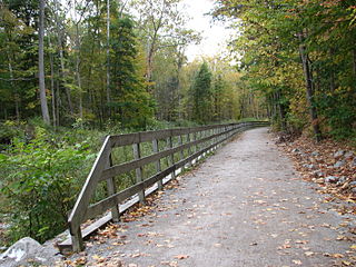
The Little Miami Scenic Trail is the fourth longest paved trail in the United States, running 78.1 miles (125.7 km) through five southwestern counties in the state of Ohio. The multi-use rail trail sees heavy recreational use by hikers and bicyclists, as well as the occasional horseback rider. Over 700,000 people made use of the trail in 2014.
The Little Miami Railroad was a railway of southwestern Ohio, running from the eastern side of Cincinnati to Springfield, Ohio. By merging with the Columbus and Xenia Railroad in 1853, it created the first through-rail route from the important manufacturing city of Cincinnati to the state capital, Columbus. In this period, railroads were important for creating connections between the important waterways of the Great Lakes and the Ohio River, which were major transportation routes for products to other markets.

The Cincinnati Enquirer is a morning daily newspaper published by Gannett in Cincinnati, Ohio, United States. First published in 1841, the Enquirer is the last remaining daily newspaper in Greater Cincinnati and Northern Kentucky, although the daily Journal-News competes with the Enquirer in the northern suburbs. The Enquirer has the highest circulation of any print publication in the Cincinnati metropolitan area. A daily local edition for Northern Kentucky is published as The Kentucky Enquirer. The Enquirer won the 2018 Pulitzer Prize for local reporting for its project titled "Seven Days of Heroin".

The Cincinnati Post was an afternoon daily newspaper published in Cincinnati, Ohio, United States. In Northern Kentucky, it was bundled inside a local edition called The Kentucky Post.

Hamilton Township is one of the eleven townships of Warren County, Ohio, United States. It is located in the south central portion of the county. The population was 30,587 at the 2020 census.

The Midtown Greenway is a 5.7-mile (9.2 km) rail trail in Minneapolis, Minnesota that follows the path of an abandoned route of the Milwaukee Road railway. It is considered under segregated cycle facilities.

Blue Ash Airport, also known as Cincinnati–Blue Ash Airport, was a public airport located in Blue Ash, Ohio, United States and owned by the City of Cincinnati. Located 16.5 miles (26.6 km) northeast of downtown Cincinnati, it served as a general aviation reliever for the Cincinnati/Northern Kentucky International Airport.

The Lebanon Countryside Trail is a rail trail in Ohio.

Loveland High School is a public high school located in Loveland, Ohio, United States, within Hamilton County. It is the only high school in the Loveland City School District, serving the communities of Loveland, Symmes Township, Goshen Township, and Miami Township. It offers a range of educational programs, including college preparatory and vocational.
The Loveland City School District, known locally as Loveland City Schools, is a city school district that covers more than 15 square miles (39 km2) in three counties — Clermont, Hamilton, and Warren — in the U.S. state of Ohio. The district encompasses the city of Loveland and reaches into Goshen, Hamilton, Miami, and Symmes Townships. Loveland Schools serves a population of 50,000 residents, including the city of Loveland. Fewer than 40% of students reside in the city proper. Loveland Schools' current student enrollment is 4,200 in six schools for the 2022-23 school year. Until May 2013, the district superintendent was Chad Hilliker. Dr. Amy Crouse succeeded Hilliker as superintendent of the school district starting May 1, 2017, until her resignation in December 2020 following a failed school funding levy. Mike Broadwater has served as superintendent since August 2021.
The James A. Ramage Civil War Museum sought to tell the untold story of Cincinnati, Ohio, and Northern Kentucky's involvement in the American Civil War. Although no battles occurred there, the people of the area resisted a push by the Confederate army in 1862. The museum was located in Fort Wright, Kentucky on the site of Hooper Battery. The museum grounds covered 17 acres (69,000 m2) and it displayed historical passages, stories, and memorabilia. It also paid homage to the Black Brigade of Cincinnati, Fern Storer's kitchen, and the history of the City of Fort Wright.
The Ohio to Erie Trail is a dedicated multi-use trail crossing Ohio from southwest to northeast, crossing 326 mi (525 km) of regional parks, nature preserves, and rural woodland.
Xenia Station, located at 150 Miami Avenue in Xenia, Ohio, in the United States, is a replica of Xenia's 1880s brick railroad station.

Cycling in Canada is experienced in various ways across a geographically huge, economically and socially diverse country. Among the reasons for cycling in Canada are for practical reasons such as commuting to work or school, for sports such as road racing, BMX, mountain bike racing, freestyle BMX, as well as for pure recreation. The amount and quality of bicycle infrastructure varies widely across the country as do the laws pertaining to cyclists such as bicycle helmet laws which can differ by province.
Branch Hill is an unincorporated community in Miami Township, Clermont County, Ohio, United States, on the banks of the Little Miami River near Loveland. The Little Miami Scenic Trail passes through Branch Hill.
The Oasis Subdivision is a rail line in and near eastern Cincinnati. It is owned by the Southwest Ohio Regional Transit Authority (SORTA) and operated by the Indiana and Ohio Railway for freight traffic.

