
The Little Sandy River is a tributary of the Ohio River in northeastern Kentucky in the United States. It is 85.4 miles (137.4 km) long drains an area of 724.2 square miles (1,876 km2). Via the Ohio, it is part of the Mississippi River watershed.

The Little Scioto River is a tributary of the Ohio River, about 42.8 miles (68.9 km) long, in southern Ohio in the United States. Via the Ohio River, it is part of the watershed of the Mississippi River, draining an area of 233 square miles (600 km2).
Tygarts Creek is a tributary of the Ohio River in Carter and Greenup counties of northeastern Kentucky in the United States. It is 88 miles (142 km) long and drains an area of 339.6 square miles (880 km2). Via the Ohio, it is part of the watershed of the Mississippi River. Tygarts Creek is named for early Kentucky explorer Michael Tygart, who eventually drowned in the creek, somewhere near the mouth.
Gifford State Forest is the smallest state forest in the U.S. state of Ohio. It includes some hiking trails, forested hills and bluffs, and a small breeding nursery. It is located in Bern Township, Athens County.
Zaleski State Forest is a state forest in the U.S. state of Ohio, located primarily in Vinton County, with areas in Athens County as well. The 28,000 acre (110 km²) forest surrounds Lake Hope State Park in Vinton County, and borders the Waterloo Wildlife Research Station in Athens County.
Beaver Creek State Forest is a state forest in Columbiana County, Ohio, United States.
Blue Rock State Forest is a state forest in Muskingum County, Ohio, United States.
Brush Creek State Forest is a state forest in Adams County, Ohio, United States.
Sunfish Creek State Forest is a state forest in Monroe County, Ohio, United States.
Tar Hollow State Forest is a state forest in Hocking, Ross, and Vinton counties in the U.S. state of Ohio. It is part of an area of protected land that also includes Tar Hollow State Park.
Yellow Creek State Forest is a state forest in Columbiana County, Ohio, United States.

The Trimble Community Forest or Trimble Township Community Forest is a 1,200-acre (4.9 km2) forest preserve owned by the Appalachia Ohio Alliance, a land trust located in southeast Ohio. Formerly called Taylor Ridge, it was purchased in 2006 from the Sunday Creek Coal Company, and was formerly part of the Sunday Creek State Wildlife Area. The land has a long history of coal, oil, natural gas, and timber production. The AOA negotiated with the Trimble Township Trustees on its use before purchase. It is located in Athens County, Ohio, south of Ohio State Route 78, between Glouster, Ohio and Murray City, Ohio.
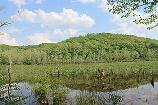
Raccoon Creek is a 114-mile-long (183 km) stream that drains parts of five Ohio counties in the United States. It originates in Hocking County, Ohio. It flows through Vinton County and Gallia County and a corner of Meigs County. Its largest tributary, Little Raccoon Creek, arises in Jackson County. The watershed also includes part of Athens County, drained by another tributary, Hewett Fork. The other major tributaries are Elk Fork, located entirely in Vinton County, and Brushy Fork, which is mostly in Vinton County with a small area in Hocking County.

The Vinton Furnace State Experimental Forest and Raccoon Ecological Management Area (REMA) is a state forest in Vinton County, Ohio, United States. It comprises 15,849 acres, the largest remaining intact block of forest in Ohio still available for permanent protection. Since 2000, data collected at the forest has been cited in nearly 200 academic articles.
Rocky Hill is an unincorporated community in Bloomfield Township, Jackson County, Ohio, United States. It is located southeast of Jackson along U.S. Route 35, next to Winchester at the intersection of C H & D Road and Dixon Run Road, at 38°59′20″N82°32′42″W.
Petersburg is an unincorporated community in Scioto Township, Jackson County, Ohio, United States. It is located southwest of Jackson along Ohio State Route 776 at its intersection with Petersburg Road at 38°59′23″N82°44′40″W.
Kitchen is an unincorporated community in Madison Township, Jackson County, Ohio, United States. It is located southeast of Oak Hill at the intersection of Ohio State Route 233 and CH&D Road, at 38°52′11″N82°32′34″W.
Horeb is an unincorporated community in Jefferson Township, Jackson County, Ohio, United States. It is located west of Oak Hill on Ohio State Route 279, at 38°54′12″N82°36′44″W.
Mabee Corner is an unincorporated community in Hamilton Township, Jackson County, Ohio, United States. It is located west of Oak Hill at the intersection of Bucklick Creek Road and Ohio State Route 139, at 38°54′10″N82°43′16″W.
Monroe is an unincorporated community in Jefferson Township, Jackson County, Ohio, United States. It is located southwest of Oak Hill on Ohio State Route 140 between Blackfork Junction and Firebrick, at 38°51′23″N82°37′45″W.

