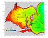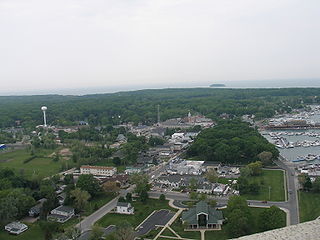
Put-in-Bay is a village located on South Bass Island in Put-in-Bay Township, Ottawa County, Ohio, United States 35 miles (56 km) east of Toledo. The population was 138 at the 2010 census.

The Bass Islands are three American islands in the western half of Lake Erie. They are north of Sandusky, Ohio, and south of Pelee Island, Ontario. South Bass Island is the largest of the islands, followed closely by North Bass Island and Middle Bass Island. They are located in Put-in-Bay Township, Ottawa County in the state of Ohio. Historically Middle Bass has also been called Ile de Fleurs and North Bass was known as Isle St. George.

The Ottawa River, also known as Ottawa Creek, is a short river, approximately 20 miles (32 km) long, in northwest Ohio and southeast Michigan in the United States. It drains an area on the Ohio-Michigan border along the eastern and northern fringes of the city of Toledo, goes through Ottawa Hills, and empties directly into Lake Erie. It is one of two rivers in northwestern Ohio that share the same name, along with the Ottawa River that is a tributary of the Auglaize River. The upper 4 miles (6 km) of the river in Michigan north of Sylvania, Ohio is called North Tenmile Creek on federal maps, while another branch rising in Fulton County, Ohio, is called Tenmile Creek.

Middle Bass Island is an island of the U.S. state of Ohio, located in Lake Erie. A small town, Middle Bass, lies on the island. The 805-acre (3.258 km²) island is shaped like the Big Dipper and is one of three Bass Islands located at the center of a group of 23 smaller islands. It is located in Put-in-Bay Township, Ottawa County, Ohio.

North Bass Island is an island of the U.S. state of Ohio located in Lake Erie. A small unincorporated community, Isle Saint George, is on the island. The North Bass Island Post Office was established on May 25, 1864, and the name changed to Isle Saint George Post Office on March 2, 1874. The Isle Saint George ZIP code 43436 provides PO Box service.

South Bass Island is a small island in western Lake Erie, and a part of Ottawa County, Ohio, United States. It is the southernmost of the three Bass Islands and located 3 miles (4.6 km) from the south shore of Lake Erie. It is the third largest island in the Lake Erie Islands, and is part of Put-in-Bay Township. In the bay of South Bass is Gibraltar Island, home to the Ohio State University's Stone Laboratory.

Lost Ballast Island is an island in the U.S. state of Ohio, located in Lake Erie. The island was once a part of Ballast Island, but has since sunk into Lake Erie to become a reef. During periods of low water the island reappears. It is located in Put-in-Bay Township, Ottawa County, Ohio.

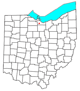
The Sandusky River is a tributary to Lake Erie in north-central Ohio in the United States. It is about 133 miles (214 km) long and flows into Lake Erie at the southwest side of Sandusky Bay.

The Vermilion River is a river in northern Ohio in the United States. It is 66.9 miles (107.7 km) long and is a tributary of Lake Erie, draining an area of 268 square miles (690 km2). The name alludes to the reddish clay that is the predominant local soil along its route. The river is commonly muddy after rains.

The Black River is a tributary of Lake Erie, about 12 mi (19 km) long, in northern Ohio in the United States. Via Lake Erie, the Niagara River and Lake Ontario, it is part of the watershed of the St. Lawrence River, which flows to the Atlantic Ocean. The Black drains an area of 470 mi² (1217 km²).

Danbury Township is one of the twelve townships of Ottawa County, Ohio, United States. The 2000 census found 4,631 people in the township, 3,869 of whom lived in the unincorporated portions of the township.
Portage Township is one of the twelve townships of Ottawa County, Ohio, United States. The 2000 census found 1,634 people in the unincorporated portions of the township.
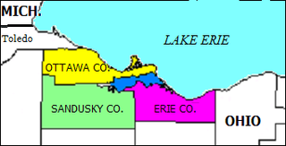
Sandusky Bay is a bay on Lake Erie in northern Ohio, formed at the mouth of the Sandusky River. It was identified as Lac Sandouské on a 1718 French map, with early variations recorded that suggest the name was derived from Native American languages. The Thomas A. Edison Memorial Bridge was constructed across it in the 20th century to connect highways in Erie and Ottawa counties.

Avery is an unincorporated community in western Milan Township, Erie County, Ohio, United States. It is part of the Sandusky Metropolitan Statistical Area. Avery is located along US Route 250 near that road's interchange with Interstate 80 and Interstate 90, the Ohio Turnpike. The area is characterized by hotels and some industry. It once had a post office, but is now included in the Milan, Ohio postal zone (44846).
Bloomingville is an unincorporated community in northern Oxford Township, Erie County, Ohio, United States. It is part of the Sandusky Metropolitan Statistical Area. Bloomingville is located at the intersection of Mason Road and Patten Tract Road. The Oxford Grange Hall located where Taylor Road forks off from Mason was the center of community life for many years. The Bloomingville Cemetery is located behind the Grange Hall and runs from Mason through to Taylor Road. The compact community consisted primarily of farmhouses clustered near the main intersection. Many of the farmhouses had working farms adjoining them or nearby. To the northeast lay an unused tract of 9,000 acres (36 km²) that had been the site of a World War II munitions factory. In 1957, NASA acquired part of this tract for its Plum Brook Station and by 1963 had acquired the rest of the tract to build additional facilities there.

St. Martin Island is located off the Garden Peninsula in Delta County in the U.S. state of Michigan. It is the southernmost island in Michigan that is part of a line of islands at the mouth of the bay of Green Bay and is part of the Niagara Escarpment.

Green Island is a small 17-acre (0.07 km²) island of the U.S. state of Ohio, in Lake Erie. It is located approximately three miles southwest of Put-in-Bay. It is part of Put-in-Bay Township, in Ottawa County.

Beulah Beach is an unincorporated community and census-designated place located adjacent to Lake Erie in Erie County, Ohio, United States. As of the 2010 census it had a population of 53. It is located within Vermilion Township.