Old Washington, Ohio

Last updated

Old Washington, Ohio
Old Washington Historic District.jpg
Downtown Old Washington
OHMap-doton-Old Washington.png
Location of Old Washington, Ohio
Detailed map of Old Washington.png
Detailed map of Old Washington
Coordinates: 40°02′15″N81°26′39″W / 40.03750°N 81.44417°W / 40.03750; -81.44417
Country United States
State Ohio
County Guernsey
Township Wills
Area
[1]
  Total0.67 sq mi (1.74 km2)
  Land0.67 sq mi (1.74 km2)
  Water0.00 sq mi (0.00 km2)
Elevation
[2]
1,004 ft (306 m)
Population
 (2020)
  Total223
  Density331.85/sq mi (128.17/km2)
Time zone UTC-5 (Eastern (EST))
  Summer (DST) UTC-4 (EDT)
ZIP code
43768
Area code 740
FIPS code 39-58226 [3]
GNIS feature ID2399570 [2]

Old Washington is a village in Guernsey County, Ohio, United States. The population was 223 at the 2020 census.

Contents

History

"Morgan's Raiders," illustration for Harper's Weekly, 1863. MorganWashington.jpg
Morgan's Raiders,” illustration for Harper's Weekly , 1863.

The village has been known by several names in its history. Platted by George and Henry Beymer in 1805, [4] :344 it was initially known by two names; Beymerstown and New Washington. [5] [4] :346 It was incorporated as Washington in 1829, soon after the National Road reached it. [5] The present name was later adopted to mitigate postal confusion with the City of Washington, now known as City of Washington Court House in Fayette County. [5] [6]

In July 1863, Old Washington was the site of a small engagement during the course of Morgan's Raid. In the course of their campaign through Ohio, the Confederate raiders appeared in several Guernsey County villages, including Old Washington, where they wreaked havoc before being caught by Union cavalry. The three Confederate dead are buried at the cemetery in Old Washington. [7]

Geography

According to the United States Census Bureau, the village has a total area of 0.67 square miles (1.74 km2), all land. [8]

Demographics

Historical population
CensusPop.Note
1820 161
1830 372131.1%
1850 759
1860 741−2.4%
1870 554−25.2%
1880 6008.3%
1890 546−9.0%
1900 374−31.5%
1910 366−2.1%
1920 3834.6%
1930 336−12.3%
1940 297−11.6%
1950 3228.4%
1960 36914.6%
1970 346−6.2%
1980 279−19.4%
1990 2810.7%
2000 265−5.7%
2010 2795.3%
2020 223−20.1%
U.S. Decennial Census [9]

2010 census

As of the census of 2010, there were 279 people, 111 households, and 86 families living in the village. [10] The population density was 416.4 inhabitants per square mile (160.8/km2). There were 119 housing units at an average density of 177.6 per square mile (68.6/km2). The racial makeup of the village was 98.9% White, 0.4% Native American, and 0.7% from two or more races. Hispanic or Latino of any race were 1.4% of the population.

There were 111 households, of which 27.9% had children under the age of 18 living with them, 62.2% were married couples living together, 10.8% had a female householder with no husband present, 4.5% had a male householder with no wife present, and 22.5% were non-families. 18.9% of all households were made up of individuals, and 10.8% had someone living alone who was 65 years of age or older. The average household size was 2.51 and the average family size was 2.80.

The median age in the village was 40.1 years. 21.9% of residents were under the age of 18; 8.3% were between the ages of 18 and 24; 26.3% were from 25 to 44; 24% were from 45 to 64; and 19.7% were 65 years of age or older. The gender makeup of the village was 52.3% male and 47.7% female.

2000 census

As of the census of 2000, there were 265 people, 112 households, and 82 families living in the village. [3] The population density was 403.2 inhabitants per square mile (155.7/km2). There were 124 housing units at an average density of 188.7 per square mile (72.9/km2). The racial makeup of the village was 96.60% White, 1.89% African American, and 1.51% Asian. Hispanic or Latino of any race were 0.38% of the population.

There were 112 households, out of which 28.6% had children under the age of 18 living with them, 63.4% were married couples living together, 7.1% had a female householder with no husband present, and 25.9% were non-families. 24.1% of all households were made up of individuals, and 12.5% had someone living alone who was 65 years of age or older. The average household size was 2.37 and the average family size was 2.78.

In the village, the population was spread out, with 23.4% under the age of 18, 4.5% from 18 to 24, 25.7% from 25 to 44, 27.9% from 45 to 64, and 18.5% who were 65 years of age or older. The median age was 43 years. For every 100 females, there were 80.3 males. For every 100 females age 18 and over, there were 82.9 males.

The median income for a household in the village was $26,250, and the median income for a family was $31,667. Males had a median income of $31,406 versus $23,125 for females. The per capita income for the village was $24,399. About 7.8% of families and 13.9% of the population were below the poverty line, including 23.1% of those under the age of eighteen and 21.3% of those 65 or over.

Education

Old Washington is within the East Guernsey Local School District. Students within the village attend Buckeye Trail High School, Buckeye Trail Middle School, and Buckeye Trail Elementary School.

Related Research Articles

<span class="mw-page-title-main">Guernsey County, Ohio</span> County in the United States

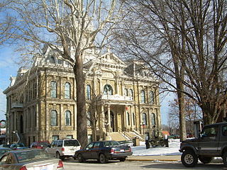
Guernsey County is a county located in the U.S. state of Ohio. As of the 2020 census, the population was 38,438. Its county seat and largest city is Cambridge. It is named for the Isle of Guernsey in the English Channel, from which many of the county's early settlers emigrated.

<span class="mw-page-title-main">Guernsey, Iowa</span> City in Iowa, United States

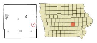
Guernsey is a town in Poweshiek County, Iowa, United States. The population was 63 at the time of the 2020 census.

<span class="mw-page-title-main">New Washington, Ohio</span> Village in Ohio, United States

New Washington is a village in Cranberry Township in Crawford County, Ohio, United States. The population was 873 at the 2020 census.

<span class="mw-page-title-main">Ashley, Ohio</span> Village in Ohio, United States

Ashley is a village in Delaware County, Ohio, United States. The population was 1,198 at the 2020 census.

<span class="mw-page-title-main">Byesville, Ohio</span> Village in Ohio, United States

Byesville is a village in Guernsey County, Ohio, United States, along Wills Creek. The population was 2,364 at the 2020 census.

<span class="mw-page-title-main">Cumberland, Ohio</span> Village in Guernsey County, Ohio, United States

Cumberland is a village in Guernsey County, Ohio, United States. It is seventy miles east of Columbus. The population was 317 at the 2020 census.

<span class="mw-page-title-main">Kimbolton, Ohio</span> Census-designated place in Ohio, United States

Kimbolton is an unincorporated community and census-designated place in Guernsey County, Ohio, United States, along Wills Creek. The population was 152 at the 2020 census.

<span class="mw-page-title-main">Lore City, Ohio</span> Village in Ohio, United States

Lore City is a village in Guernsey County, Ohio, United States. The population was 282 at the 2020 census.

<span class="mw-page-title-main">Pleasant City, Ohio</span> Village in Ohio, United States

Pleasant City is a village in Guernsey County, Ohio, United States. The population was 400 at the 2020 census.

<span class="mw-page-title-main">Quaker City, Ohio</span> Village in Ohio, United States

Quaker City is a village in Guernsey County, Ohio, United States. The population was 379 at the 2020 census.

<span class="mw-page-title-main">Salesville, Ohio</span> Census-designated place in Ohio, United States

Salesville is a census-designated place and former village in Guernsey County, Ohio, United States. As of the 2020 census, the population was 123, down from 129 at the 2010 census. Its residents voted for dissolution in 2016.

<span class="mw-page-title-main">Senecaville, Ohio</span> Village in Ohio, United States

Senecaville is a village in Guernsey County, Ohio, United States. The population was 422 at the 2020 census.

<span class="mw-page-title-main">Dillonvale, Jefferson County, Ohio</span> Village in Ohio, United States

Dillonvale is a village in southern Jefferson County, Ohio, United States. The population was 589 at the 2020 census. It is part of the Weirton–Steubenville metropolitan area.

<span class="mw-page-title-main">Rayland, Ohio</span> Village in Ohio, United States

Rayland is a village in southern Jefferson County, Ohio, United States, along the Ohio River. The population was 389 at the 2020 census. It is part of the Weirton–Steubenville metropolitan area.

<span class="mw-page-title-main">Danville, Ohio</span> Village in Ohio, United States

Danville is a village in Knox County, Ohio, United States. The population was 1,019 at the 2020 census.

<span class="mw-page-title-main">Harbor Hills, Ohio</span> Census-designated place in Ohio, United States

Harbor Hills is a census-designated place (CDP) in southern Licking County, Ohio, United States. The population was 1,565 at the 2020 census.

<span class="mw-page-title-main">Belle Valley, Ohio</span> Village in Ohio, United States

Belle Valley is a village in Noble County, Ohio, United States. The population was 201 at the 2020 census.

<span class="mw-page-title-main">Fairview, Ohio</span> Village in Ohio, United States

Fairview is a village in Belmont and Guernsey counties in the U.S. state of Ohio. The population was 67 as of the 2020 census. It is part of the Wheeling metropolitan area.

<span class="mw-page-title-main">Yorkville, Ohio</span> Village in Ohio, United States

Yorkville is a village in Belmont and Jefferson counties in the U.S. state of Ohio. The population was 968 at the 2020 census. Yorkville lies within two Metropolitan Statistical Areas; the Belmont County portion is part of the Wheeling metropolitan area, while the Jefferson County portion is part of the Weirton–Steubenville metropolitan area.

<span class="mw-page-title-main">Buckeye Lake, Ohio</span> Village in Ohio, United States

Buckeye Lake is a village in Fairfield and Licking counties in the U.S. state of Ohio. The population was 2,520 at the 2020 census. It is named for Buckeye Lake, a large lake along which the village is built.

References

  1. "ArcGIS REST Services Directory". United States Census Bureau. Retrieved September 20, 2022.
  2. 1 2 U.S. Geological Survey Geographic Names Information System: Old Washington, Ohio
  3. 1 2 "U.S. Census website". United States Census Bureau. Retrieved January 31, 2008.
  4. 1 2 Sarchet, Cyrus Parkinson Beatty (1911). History of Guernsey County, Ohio, Volume 1. B.F. Bowen & Company.
  5. 1 2 3 Overman, William Daniel (1958). Ohio Town Names. Akron, OH: Atlantic Press. p. 104.
  6. "Old Washington Historical Marker". hmdb.org. Retrieved April 4, 2020.
  7. Russell Booth, Jr., A Brief History of Guernsey County , Guernsey County, 2008. Accessed 2009-02-06.
  8. "US Gazetteer files 2010". United States Census Bureau. Archived from the original on January 25, 2012. Retrieved January 6, 2013.
  9. "Census of Population and Housing". Census.gov. Retrieved June 4, 2015.
  10. "U.S. Census website". United States Census Bureau. Retrieved January 6, 2013.