Londonderry, Guernsey County, Ohio

Last updated
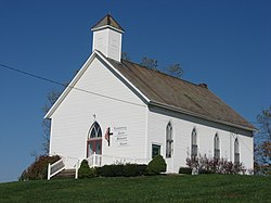
Methodist church Londonderry Methodist Church in Guernsey County.jpg
Methodist church

Londonderry is an unincorporated community in Londonderry Township, Guernsey County, Ohio, United States. [1]

History

Londonderry was platted in 1815. [2] The community takes its name from Londonderry, in Northern Ireland. [3] A post office was established at Londonderry in 1819, and remained in operation until 1907. [4]

Related Research Articles

Guernsey County, Ohio U.S. county in Ohio

Guernsey County is a county located in the U.S. state of Ohio. As of the 2010 census, the population was 40,087. Its county seat is Cambridge, and it is named for the Isle of Guernsey in the English Channel, from which many of the county's early settlers emigrated.

Kimbolton, Ohio Census-designated place in Ohio, United States

Kimbolton is an unincorporated community and census-designated place in Guernsey County, Ohio, United States, along Wills Creek. The population was 144 at the 2010 census, down from 190 at the 2000 census, at which time it was a village.

Derwent, Ohio human settlement in Ohio, United States of America

Derwent is an unincorporated community in central Valley Township, Guernsey County, Ohio, United States. It is located near the southern border of Guernsey and Noble counties.

Londonderry, Ross County, Ohio human settlement in Ohio, United States of America

Londonderry is an unincorporated community in eastern Liberty Township, Ross County, Ohio, United States. Although it is unincorporated, it has a post office, with the ZIP code of 45647. It lies along U.S. Route 50 at its intersection with State Route 327.

Birmingham, Guernsey County, Ohio human settlement in Ohio, United States of America

Birmingham is an unincorporated community in southeastern Monroe Township, Guernsey County, Ohio, United States. It lies at the intersection of Beal, Birmingham, and Peoli Roads, 3 34 miles (6.0 km) south of Peoli, 7 miles east-northeast of Kimbolton, and 13 miles (21 km) northeast of central Cambridge, the county seat of Guernsey County. Nearby streams flow southward into Salt Fork Lake, which is included in Salt Fork State Park.

Peoli, Ohio human settlement in Ohio, United States of America

Peoli is an unincorporated community in Washington Township, Tuscarawas County, Ohio, United States, along State Route 258.

Gilmore is an unincorporated community in Washington Township, Tuscarawas County, Ohio, south of the village of Gnadenhutten. Gilmore sits on Tuscarawas County Road 10 and is intersected by Tuscarawas County Road 14 at Gilmore's square.

Antrim, Ohio human settlement in United States of America

Antrim is an unincorporated community in Guernsey County, in the U.S. state of Ohio.

Orange is an unincorporated community in Coshocton County, in the U.S. state of Ohio.

North Salem is an unincorporated community in Guernsey County, in the U.S. state of Ohio.

Craig is an unincorporated community in Guernsey County, in the U.S. state of Ohio.

Spencer Station is an unincorporated community in Millwood Township, Guernsey County, in the U.S. state of Ohio.

Birds Run is an unincorporated community in Guernsey County, in the U.S. state of Ohio.

Elizabethtown is an unincorporated community in Guernsey County, in the U.S. state of Ohio.

Wolf is an unincorporated community in Tuscarawas County, in the U.S. state of Ohio.

Boden is an unincorporated community in Guernsey County, in the U.S. state of Ohio.

Claysville, Ohio human settlement in United States of America

Claysville is an unincorporated community in Guernsey County, in the U.S. state of Ohio.

Guernsey is an unincorporated community in Guernsey County, in the U.S. state of Ohio.

Middlebourne is an unincorporated community in Guernsey County, in the U.S. state of Ohio.

Robins is an unincorporated community in Guernsey County, in the U.S. state of Ohio.

References

  1. U.S. Geological Survey Geographic Names Information System: Londonderry, Guernsey County, Ohio
  2. Sarchet, Cyrus Parkinson Beatty (1911). History of Guernsey County, Ohio, Volume 1. B.F. Bowen & Company. p. 336.
  3. Overman, William Daniel (1958). Ohio Town Names. Akron, OH: Atlantic Press. p. 77.
  4. "Guernsey County". Jim Forte Postal History. Retrieved 17 December 2015.

Coordinates: 40°09′17″N81°18′01″W / 40.15472°N 81.30028°W / 40.15472; -81.30028