Salesville, Ohio

Last updated
Salesville, Ohio
Main near Church, Salesville.jpg
OHMap-doton-Salesville.png
Location of Salesville, Ohio
Map of Guernsey County Ohio Highlighting Salesville Village.png
Location of Salesville in Guernsey County
Coordinates: 39°58′27″N81°20′12″W / 39.97417°N 81.33667°W / 39.97417; -81.33667
Country United States
State Ohio
County Guernsey
Township Millwood
Platted1835;189 years ago (1835)
Incorporated1878;146 years ago (1878)
Dissolved2016;8 years ago (2016)
Area
[1]
  Total0.19 sq mi (0.50 km2)
  Land0.19 sq mi (0.50 km2)
  Water0.00 sq mi (0.00 km2)
Elevation
[2]
876 ft (267 m)
Population
 (2020)
  Total123
  Density634.02/sq mi (244.29/km2)
Time zone UTC-5 (Eastern (EST))
  Summer (DST) UTC-4 (EDT)
ZIP code
43778
Area code 740
FIPS code 39-70072 [3]
GNIS feature ID2785007 [2]

Salesville is a census-designated place and former village in Guernsey County, Ohio, United States. As of the 2020 census, the population was 123, down from 129 at the 2010 census. Its residents voted for dissolution in 2016. [4]

Contents

History

Salesville was platted in 1835. [5] The village was incorporated in 1878. [5] A post office called Salesville was established in 1855, and remained in operation until 2002. [6]

In 1828 at a Salesville camp meeting, Joseph C. Dylkes made his public claim as a messiah, becoming known as the Leatherwood God.[ citation needed ]

Geography

Salesville is located along Leatherwood Creek. [7]

According to the United States Census Bureau, the village had a total area of 0.10 square miles (0.26 km2), all land. [8]

Demographics

Historical population
CensusPop.Note
1850 71
1860 12069.0%
1870 17243.3%
1880 26654.7%
1890 29611.3%
1900 286−3.4%
1910 265−7.3%
1920 247−6.8%
1930 193−21.9%
1940 21310.4%
1950 187−12.2%
1960 173−7.5%
1970 154−11.0%
1980 139−9.7%
1990 84−39.6%
2000 15483.3%
2010 129−16.2%
2020 123−4.7%
U.S. Decennial Census [9]

2010 census

As of the census [10] of 2010, there were 129 people, 50 households, and 34 families living in the village. The population density was 1,290.0 inhabitants per square mile (498.1/km2). There were 58 housing units at an average density of 580.0 per square mile (223.9/km2). The racial makeup of the village was 96.9% White, 1.6% African American, and 1.6% from two or more races.

There were 50 households, of which 42.0% had children under the age of 18 living with them, 54.0% were married couples living together, 6.0% had a female householder with no husband present, 8.0% had a male householder with no wife present, and 32.0% were non-families. 28.0% of all households were made up of individuals, and 20% had someone living alone who was 65 years of age or older. The average household size was 2.58 and the average family size was 3.15.

The median age in the village was 37.5 years. 26.4% of residents were under the age of 18; 13.9% were between the ages of 18 and 24; 24.8% were from 25 to 44; 23.3% were from 45 to 64; and 11.6% were 65 years of age or older. The gender makeup of the village was 49.6% male and 50.4% female.

2000 census

As of the census [3] of 2000, there were 154 people, 53 households, and 40 families living in the village. The population density was 1,567.6 inhabitants per square mile (605.3/km2). There were 67 housing units at an average density of 682.0 per square mile (263.3/km2). The racial makeup of the village was 99.35% White, and 0.65% from two or more races.

There were 53 households, out of which 45.3% had children under the age of 18 living with them, 60.4% were married couples living together, 9.4% had a female householder with no husband present, and 24.5% were non-families. 18.9% of all households were made up of individuals, and 15.1% had someone living alone who was 65 years of age or older. The average household size was 2.91 and the average family size was 3.38.

In the village the population was spread out, with 31.2% under the age of 18, 5.8% from 18 to 24, 33.1% from 25 to 44, 15.6% from 45 to 64, and 14.3% who were 65 years of age or older. The median age was 35 years. For every 100 females, there were 87.8 males. For every 100 females age 18 and over, there were 86.0 males.

The median income for a household in the village was $37,917, and the median income for a family was $39,583. Males had a median income of $29,375 versus $15,250 for females. The per capita income for the village was $13,250. About 7.3% of families and 12.3% of the population were below the poverty line, including 12.8% of those under the age of eighteen and 26.1% of those 65 or over.

Related Research Articles

<span class="mw-page-title-main">Guernsey County, Ohio</span> County in the United States

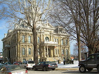
Guernsey County is a county located in the U.S. state of Ohio. As of the 2020 census, the population was 38,438. Its county seat and largest city is Cambridge. It is named for the Isle of Guernsey in the English Channel, from which many of the county's early settlers emigrated.

<span class="mw-page-title-main">Salesville, Arkansas</span> City in Arkansas, United States

Salesville is a city in Baxter County, Arkansas, United States. The population was 450 in 2010.

<span class="mw-page-title-main">Guernsey, Iowa</span> City in Iowa, United States

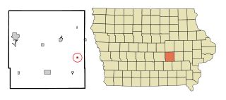
Guernsey is a town in Poweshiek County, Iowa, United States. The population was 63 at the time of the 2020 census.

<span class="mw-page-title-main">Byesville, Ohio</span> Village in Ohio, United States

Byesville is a village in Guernsey County, Ohio, United States, along Wills Creek. The population was 2,364 at the 2020 census.

<span class="mw-page-title-main">Cumberland, Ohio</span> Village in Guernsey County, Ohio, United States

Cumberland is a village in Guernsey County, Ohio, United States. It is seventy miles east of Columbus. The population was 317 at the 2020 census.

<span class="mw-page-title-main">Kimbolton, Ohio</span> Census-designated place in Ohio, United States

Kimbolton is an unincorporated community and census-designated place in Guernsey County, Ohio, United States, along Wills Creek. The population was 152 at the 2020 census.

<span class="mw-page-title-main">Lore City, Ohio</span> Village in Ohio, United States

Lore City is a village in Guernsey County, Ohio, United States. The population was 282 at the 2020 census.

<span class="mw-page-title-main">Old Washington, Ohio</span> Village in Ohio, United States

Old Washington is a village in Guernsey County, Ohio, United States. The population was 223 at the 2020 census.

<span class="mw-page-title-main">Pleasant City, Ohio</span> Village in Ohio, United States

Pleasant City is a village in Guernsey County, Ohio, United States. The population was 400 at the 2020 census.

<span class="mw-page-title-main">Quaker City, Ohio</span> Village in Ohio, United States

Quaker City is a village in Guernsey County, Ohio, United States. The population was 379 at the 2020 census.

<span class="mw-page-title-main">Senecaville, Ohio</span> Village in Ohio, United States

Senecaville is a village in Guernsey County, Ohio, United States. The population was 422 at the 2020 census.

<span class="mw-page-title-main">Addyston, Ohio</span> Village in Ohio, United States

Addyston is a village in Miami Township, Hamilton County, Ohio, United States. Located along the Ohio River, it is a western suburb of the neighboring city of Cincinnati. The population was 927 at the 2020 census.

<span class="mw-page-title-main">Gann, Ohio</span> Village in Ohio, United States

Brinkhaven, once known as Mount Holly and Gann, is a village in Knox County, Ohio, United States. The population was 114 at the 2020 census.

<span class="mw-page-title-main">New Concord, Ohio</span> Village in Ohio, United States

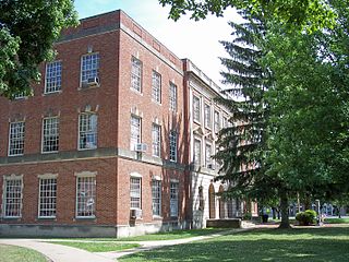
New Concord is a village in Muskingum County, Ohio, United States. The population was 2,361 as of the 2020 census. It is part of the Zanesville micropolitan area. New Concord is the home of Muskingum University and is served by a branch of the Muskingum County Library System.

<span class="mw-page-title-main">Belle Valley, Ohio</span> Village in Ohio, United States

Belle Valley is a village in Noble County, Ohio, United States. The population was 201 at the 2020 census.

<span class="mw-page-title-main">Darbyville, Ohio</span> Village in Ohio, United States

Darbyville is a village in Pickaway County, Ohio, United States. The population was 186 at the 2020 census.

<span class="mw-page-title-main">Elgin, Ohio</span> Village in Ohio, United States

Elgin is a village in Van Wert County, Ohio, United States. The population was 49 at the 2020 census. It is included within the Van Wert, Ohio Micropolitan Statistical Area.

<span class="mw-page-title-main">Macksburg, Ohio</span> Village in Ohio, United States

Macksburg is a village in Washington County, Ohio, United States, along the West Fork of Duck Creek. The population was 120 at the 2020 census. The village is about 28 miles (45 km) south of Cambridge, Ohio.

<span class="mw-page-title-main">Fairview, Ohio</span> Village in Ohio, United States

Fairview is a village in Belmont and Guernsey counties in the U.S. state of Ohio. The population was 67 as of the 2020 census. It is part of the Wheeling metropolitan area.

<span class="mw-page-title-main">Verona, Ohio</span> Village in Ohio, United States

Verona is a village in Montgomery and Preble counties in the U.S. state of Ohio. The population was 403 at the 2020 census. It is part of the Dayton Metropolitan Statistical Area.

References

  1. "ArcGIS REST Services Directory". United States Census Bureau. Retrieved September 20, 2022.
  2. 1 2 U.S. Geological Survey Geographic Names Information System: Salesville, Ohio
  3. 1 2 "U.S. Census website". United States Census Bureau . Retrieved 2008-01-31.
  4. Fugleberg, Jeremy (February 25, 2016). "Hit by floods and budget cuts, village to vote on disappearing". The Cincinnati Enquirer . Gannett Company. Retrieved February 26, 2016.
  5. 1 2 Sarchet, Cyrus Parkinson Beatty (1911). History of Guernsey County, Ohio, Volume 1. B.F. Bowen & Company. p. 315.
  6. "Guernsey County". Jim Forte Postal History. Retrieved 17 December 2015.
  7. Ohio Atlas & Gazetteer. Yarmouth, Me.: DeLorme. 1991. p. 72. ISBN   0-89933-233-1.
  8. "US Gazetteer files 2010". United States Census Bureau. Archived from the original on 2012-01-25. Retrieved 2013-01-06.
  9. "Census of Population and Housing". Census.gov. Retrieved June 4, 2015.
  10. "U.S. Census website". United States Census Bureau . Retrieved 2013-01-06.