
Scioto County is a county along the Ohio River in the south-central part of the U.S. state of Ohio. At the 2020 census, the population was 74,008. Its county seat is Portsmouth. The county was founded on March 24, 1804, from Adams County and is named for a Native American word referring to deer or deer-hunting. Scioto County comprises the Portsmouth, OH Micropolitan Statistical Area. It is at the confluence of the Scioto and Ohio rivers.

This is a list of properties and districts in Ohio that are listed on the National Register of Historic Places. There are over 4,000 in total. Of these, 73 are National Historic Landmarks. There are listings in each of Ohio's 88 counties.

Minford is a census-designated place located on the border of Harrison and Madison townships in northeastern Scioto County, Ohio, United States, about 14 miles (23 km) northeast of the county seat of Portsmouth. As of the 2020 census, it had a population of 641.

State Route 728 is a short east–west state highway situated in south-central Ohio. At a length of just under 2 miles (3.2 km), the state highway is a spur route that provides access to the Southern Ohio Correctional Facility. The western terminus of SR 728 is at a signalized intersection with U.S. Route 23 (US 23) in Lucasville that doubles as the eastern terminus of SR 348. Its eastern terminus is just east of the Southern Ohio Correctional Facility, at the intersection of Lucasville-Minford Road and Lang Lane (CR 180).
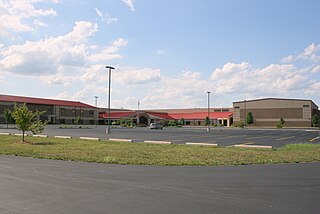
Minford High School (MHS) is a rural, public, high school located in Minford in Scioto County in Southern Ohio. It is the only high school in the Minford Local School District. The school mascot is the falcon and the school colors are scarlet and grey.
Harrison Township is one of the sixteen townships of Scioto County, Ohio, United States. The 2020 census counted 4,275 people in the township.

Byer is an unincorporated community in northwestern Washington Township, Jackson County, Ohio, United States. It lies along State Route 327 between Wellston and Londonderry.

Augspurger Schoolhouse is a historic building in Woodsdale, Ohio. The original building was a rectangular schoolhouse. On November 1, 1984 it was listed in the National Register of Historic Places as part of a thematic resource, the "Augspurger Amish/Mennonite Settlement". As of 2016 the building had been demolished and the property left covered in detritus.

The Ashville Depot is a small former train station in the village of Ashville in Pickaway County, Ohio, United States. A simple weatherboaded building that was constructed in 1876, it was once the commercial center of the area.
Mule Town or Purdy Corners is an unincorporated community in southwestern Madison Township, Scioto County, Ohio, United States. Located at the intersection of State Route 335, Lucasville-Minford Road and Bennett Road, it lies just north of the unincorporated community of Minford, 7 miles east of the census-designated place of Lucasville, and 14 miles (23 km) northeast of the city of Portsmouth, the county seat of Scioto County. Sweet Run, a tributary of the Rocky Fork of the Little Scioto River, flows past the community.

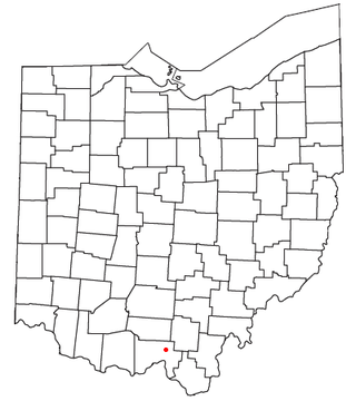
This is a list of the National Register of Historic Places listings in Scioto County, Ohio.
Bergstresser / Dietz Bridge, the last remaining covered bridge in Franklin County, Ohio, United States, is located within the village limits of Canal Winchester, Ohio in southeastern Franklin County. The wooden bridge crosses Little Walnut Creek, which is a tributary of the Scioto River. Although the bridge is in serviceable condition, it is only open to foot traffic.

The Portsmouth Earthworks are a large prehistoric mound complex constructed by the Native American Adena and Ohio Hopewell cultures of eastern North America. The site was one of the largest earthwork ceremonial centers constructed by the Hopewell and is located at the confluence of the Scioto and Ohio Rivers, in present-day Ohio.
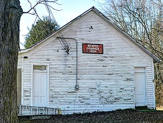
The Scioto Grange No. 1234, in Jackson, Ohio, served historically as a meeting hall, as a school, and as a specialty store. It was listed on the National Register of Historic Places in 2005.

St. Mary of the Annunciation Roman Catholic Church is a historic church of the Roman Catholic Diocese of Columbus in Portsmouth, Ohio. It was built in 1870 and added to the National Register of Historic Places in 1979.

The Old Schoolhouse Bridge is a historic covered bridge spanning the South Wheelock Branch of the Passumpsic River in Lyndon, Vermont. It is located just south of South Wheelock Road, which it formerly carried. Built in 1871, it is one five similar bridges in Lyndon. It was listed on the National Register of Historic Places in 1971.

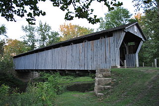
The Otway Covered Bridge, in Scioto County, Ohio north of Ohio State Route 348 in Otway, was built in 1874 by the Smith Bridge Co. of Toledo, Ohio. It was listed on the National Register of Historic Places in 1974.

The Discovery Bridge, commonly known as the Broad Street Bridge, is a bridge in Columbus, Ohio, United States, carrying Broad Street over the Scioto River and connecting Downtown Columbus to Franklinton. The bridge was named in reference to Christopher Columbus's "discovery" of the Americas; the bridge includes artistic bronze medallions featuring symbols of the explorer.

The Columbus Civic Center is a civic center, a collection of government buildings, museums, and open park space in Downtown Columbus, Ohio. The site is located along the Scioto Mile recreation area and historically was directly on the banks of the Scioto River.

Broad Street is a major thoroughfare in Central Ohio, predominantly in Franklin County and Columbus. It stretches east from West Jefferson at Little Darby Creek to Pataskala. The street is considered one of Columbus's two main roads, along with High Street.

