Little Scioto River (Ohio River tributary)

Last updated
Little Scioto River

LittleSciotoRiver.jpg

Near its confluence with the Ohio River at Sciotoville
Physical characteristics
Length 43 miles (69 km)
Basin features
Basin size 233 sq mi (600 km2)

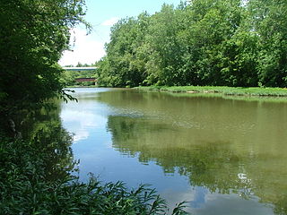
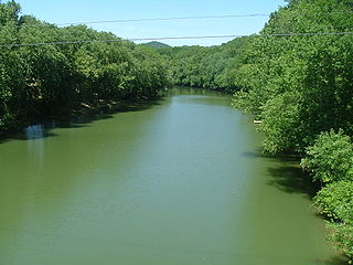
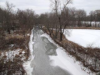
The Little Scioto River is a tributary of the Ohio River, about 42.8 miles (68.9 km) long, [1] in southern Ohio in the United States. Via the Ohio River, it is part of the watershed of the Mississippi River, draining an area of 233 square miles (600 km2). [2]

Tributary stream or river that flows into a main stem river or lake

A tributary or affluent is a stream or river that flows into a larger stream or main stem river or a lake. A tributary does not flow directly into a sea or ocean. Tributaries and the main stem river drain the surrounding drainage basin of its surface water and groundwater, leading the water out into an ocean.

Ohio River river in the midwestern United States

The Ohio River is a 981-mile (1,579 km) long river in the midwestern United States that flows southwesterly from western Pennsylvania south of Lake Erie to its mouth on the Mississippi River at the southern tip of Illinois. It is the second largest river by discharge volume in the United States and the largest tributary by volume of the north-south flowing Mississippi River that divides the eastern from western United States. The river flows through or along the border of six states, and its drainage basin includes parts of 15 states. Through its largest tributary, the Tennessee River, the basin includes several states of the southeastern U.S. It is the source of drinking water for three million people.

United States Federal republic in North America

The United States of America (USA), commonly known as the United States or America, is a country comprising 50 states, a federal district, five major self-governing territories, and various possessions. At 3.8 million square miles, the United States is the world's third or fourth largest country by total area and is slightly smaller than the entire continent of Europe's 3.9 million square miles. With a population of over 327 million people, the U.S. is the third most populous country. The capital is Washington, D.C., and the largest city by population is New York City. Forty-eight states and the capital's federal district are contiguous in North America between Canada and Mexico. The State of Alaska is in the northwest corner of North America, bordered by Canada to the east and across the Bering Strait from Russia to the west. The State of Hawaii is an archipelago in the mid-Pacific Ocean. The U.S. territories are scattered about the Pacific Ocean and the Caribbean Sea, stretching across nine official time zones. The extremely diverse geography, climate, and wildlife of the United States make it one of the world's 17 megadiverse countries.

The Little Scioto River rises in western Jackson County and flows generally southwardly into Scioto County, near Minford. It flows into the Ohio River in the eastern part of the city of Portsmouth, [3] 6 mi (10 km) east of the town's center. [4]

Jackson County, Ohio County in the United States

Jackson County is a county located in the U.S. state of Ohio. As of the 2010 census, the population was 33,225. Its county seat is Jackson. The county is named for Andrew Jackson, a hero of the War of 1812 who was subsequently elected President of the United States. It is known as "The Little Wales of Ohio."

Scioto County, Ohio County in the United States

Scioto County is a county located along the Ohio River in the south central region of the U.S. state of Ohio. As of the 2010 census, the population was 79,499. Its county seat is Portsmouth. The county was founded March 24, 1803 from Adams County and is named for an Indian word referring to deer or deer-hunting.

Minford, Ohio Census-designated place in Ohio, United States

Minford is a census-designated place located on the border of Harrison and Madison townships in northeastern Scioto County, Ohio, United States, about 14 miles (23 km) northeast of the county seat of Portsmouth. As of the 2010 census, it had a population of 693.

The United States Board on Geographic Names settled on "Little Scioto River" as the stream's name in 1913. According to the Geographic Names Information System, the Little Scioto has also been known historically as "Brushy Fork," "Little Siota River" and "Little Sciota River." [5]

United States Board on Geographic Names US geographic naming government agency

The United States Board on Geographic Names (BGN) is a federal body operating under the United States Secretary of the Interior. The purpose of the board is to establish and maintain uniform usage of geographic names throughout the federal government of the United States.

Geographic Names Information System geographical database

The Geographic Names Information System (GNIS) is a database that contains name and locative information about more than two million physical and cultural features located throughout the United States of America and its territories. It is a type of gazetteer. GNIS was developed by the United States Geological Survey in cooperation with the United States Board on Geographic Names (BGN) to promote the standardization of feature names.

See also

Related Research Articles

Boone River river in the United States of America

The Boone River is a tributary of the Des Moines River in north-central Iowa in the United States. It is 111 miles (179 km) long and drains an area of 895 square miles (2,320 km2). Via the Des Moines River, it is part of the watershed of the Mississippi River.

Flatrock River river in the United States of America

The Flatrock River, also known as Flatrock Creek and other variants of the two names, is a 98-mile-long (158 km) tributary of the East Fork of the White River in east-central Indiana in the United States. Via the White, Wabash and Ohio rivers, it is part of the watershed of the Mississippi River, draining an area of 532 square miles (1,380 km2).

Walhonding River river in the United States of America

The Walhonding River is a principal tributary of the Muskingum River, 23.5 miles (37.8 km) long, in east-central Ohio in the United States. Via the Muskingum and Ohio Rivers, it is part of the watershed of the Mississippi River. It drains an area of 2,252 square miles (5,833 km²).

Kokosing River river in the United States of America

The Kokosing River (ko-KO-sing) is a tributary of the Walhonding River, 57.2 miles (92.1 km) long, in east-central Ohio in the United States. Via the Walhonding, Muskingum and Ohio Rivers, it is part of the watershed of the Mississippi River, draining an area of 482 square miles (1248 km²). Etymologically, "Kokosing" translates roughly to "River of Little Owls." The Kokosing River rises in Morrow County, northeast of Mount Gilead, and initially flows southwardly. It turns eastwardly near Chesterville and flows through Knox and Coshocton Counties, passing the communities of Mount Vernon, Howard and Gambier. In western Coshocton County the Kokosing joins the Mohican River to form the Walhonding River, about 2 miles (3 km) northwest of Nellie.

Chikaskia River river in the United States of America

The Chikaskia River is a 159-mile-long (256 km) tributary of the Salt Fork of the Arkansas River in southern Kansas and northern Oklahoma in the United States. Via the Salt Fork and Arkansas rivers, it is part of the watershed of the Mississippi River.

Embarras River (Illinois) river in the United States of America

The Embarras River is a 195-mile-long (314 km) tributary of the Wabash River in southeastern Illinois in the United States. The waters of the Embarras reach the Gulf of Mexico via the Wabash, Ohio, and Mississippi Rivers. The river drains a watershed around 1,566,450 acres (6,339.2 km2) in an agricultural region. The name comes from French explorers, who used the term embarras for river obstacles, blockages, and difficulties relating to logjams and the like.

Little Wabash River river in the United States of America

The Little Wabash River is a 240-mile-long (390 km) tributary of the Wabash River in east-central and southeastern Illinois in the United States. Via the Wabash and Ohio rivers, it is part of the watershed of the Mississippi River. It is the third largest tributary after the White River and the Embarras River.

The Pond River is a 90.8-mile-long (146.1 km) tributary of the Green River in western Kentucky in the United States. Via the Green and Ohio rivers, it is part of the watershed of the Mississippi River.

Paint Creek (Scioto River tributary) river in the United States of America

Paint Creek is a tributary of the Scioto River, 94.7 mi (152.5 km) long, in south-central Ohio in the United States. Via the Scioto and Ohio Rivers, it is part of the watershed of the Mississippi River. It drains an area of 1,143 mi² (2960 km²).

Rattlesnake Creek (Ohio) river in the United States of America

Rattlesnake Creek is a tributary of Paint Creek, 42.3 mi (68.1 km) long, in south-central Ohio in the United States. Via Paint Creek and the Scioto and Ohio Rivers, it is part of the watershed of the Mississippi River, draining an area of 277 mi² (717 km²). According to the Geographic Names Information System, it has also been known historically as "Rattlesnake Fork."

Shenango River river in the United States of America

The Shenango River is a principal tributary of the Beaver River, approximately 100 mi (160 km) long, in western Pennsylvania in the United States. It also briefly flows through small portions of northeastern Ohio. Via the Beaver and Ohio Rivers, it is part of the watershed of the Mississippi River.

The Little Scioto River is a tributary of the Scioto River, 27.2 mi (43.8 km) long, in central Ohio in the United States. Via the Scioto and Ohio Rivers, it is part of the watershed of the Mississippi River, draining an area of 111 mi² (287 km²).

Tygarts Creek is a tributary of the Ohio River in northeastern Kentucky in the United States. It is 88 miles (142 km) long and drains an area of 339.6 square miles (880 km2). Via the Ohio, it is part of the watershed of the Mississippi River. Tygarts Creek is named for early Kentucky explorer Michael Tygart, who eventually drowned in the creek, somewhere near the mouth.

Ohio Brush Creek river in the United States of America

Ohio Brush Creek is a 59.9-mile-long (96.4 km) tributary of the Ohio River in southern Ohio in the United States. Via the Ohio River, it is part of the watershed of the Mississippi River, draining an area of 435 square miles (1,130 km2). According to the Geographic Names Information System, it has also been known historically as "Brush Creek," "Elk Creek," and "Little Scioto River"

Loramie Creek is a 40.0-mile-long (64.4 km) tributary of the Great Miami River in western Ohio in the United States. Via the Great Miami and Ohio rivers, it is part of the watershed of the Mississippi River, draining an area of 265 square miles (690 km2). According to the Geographic Names Information System, the stream has also been known historically as "Laramie Creek," "Loramie Ditch," "Loramies Creek," and "Lonamie Creek." It is named after Louis Lorimier, a French-Canadian fur trader who had a trading post in the area in the 18th century.

Moxahala Creek river in the United States of America

Moxahala Creek is a tributary of the Muskingum River, 29.2 miles (47.0 km) long, in southeastern Ohio in the United States. Via the Muskingum and Ohio Rivers, it is part of the watershed of the Mississippi River, draining an area of 301 square miles (780 km²)

Middle River (Iowa) river in Iowa

The Middle River is a tributary of the Des Moines River in south-central Iowa in the United States. It is 123 miles (198 km) long and drains an area of 489.5 square miles (1,268 km2). Via the Des Moines River, it is part of the watershed of the Mississippi River.

Lake Fork Mohican River river in the United States of America

The Lake Fork is a tributary of the Mohican River, 14.7 miles (23.7 km) long, in north-central Ohio in the United States. Via the Mohican, Walhonding, Muskingum and Ohio Rivers, it is part of the watershed of the Mississippi River, draining an area of 344 square miles (891 km²).

The Little Androscoggin River is a 51.4-mile-long (82.7 km) river in Maine. It flows from Bryant Pond in Woodstock to its confluence with the Androscoggin River in Auburn. The Androscoggin flows into Merrymeeting Bay in the Kennebec River estuary.

Leatherwood Creek (Wills Creek tributary) river in Ohio, United States of America

Leatherwood Creek is a tributary of Wills Creek, 28.6 miles (46.0 km) long, in eastern Ohio in the United States. Via Wills Creek and the Muskingum and Ohio rivers, it is part of the watershed of the Mississippi River, draining an area of 91.6 square miles (237 km2) on the unglaciated portion of the Allegheny Plateau.

References

  1. U.S. Geological Survey. National Hydrography Dataset high-resolution flowline data. The National Map Archived 2012-04-05 at WebCite , accessed May 26, 2011
  2. Map of Ohio watersheds Archived 2007-03-11 at the Wayback Machine .
  3. DeLorme (1991). Ohio Atlas & Gazetteer. Yarmouth, Maine: DeLorme. ISBN   0-89933-233-1
  4. Columbia Gazetteer of North America entry Archived 2007-03-10 at the Wayback Machine .
  5. U.S. Geological Survey Geographic Names Information System: Little Scioto River

Coordinates: 38°45′18″N82°53′05″W / 38.7551°N 82.8846°W / 38.7551; -82.8846

Geographic coordinate system Coordinate system

A geographic coordinate system is a coordinate system that enables every location on Earth to be specified by a set of numbers, letters or symbols. The coordinates are often chosen such that one of the numbers represents a vertical position and two or three of the numbers represent a horizontal position; alternatively, a geographic position may be expressed in a combined three-dimensional Cartesian vector. A common choice of coordinates is latitude, longitude and elevation. To specify a location on a plane requires a map projection.