
The North Country National Scenic Trail, generally known as the North Country Trail or simply the NCT, is a footpath stretching over 4,800 miles (7,700 km) from Middlebury in central Vermont to Lake Sakakawea State Park in central North Dakota in the United States; connecting both the Long Trail and the Appalachian Trail with the Lewis and Clark Trail. Passing through the eight states of Vermont, New York, Pennsylvania, Ohio, Michigan, Wisconsin, Minnesota and North Dakota, it is the longest of the eleven National Scenic Trails authorized by Congress. As of early 2019, 3,129 miles (5,036 km) of the trail is in place.
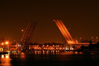
The Burnside Bridge is a 1926-built bascule bridge that spans the Willamette River in Portland, Oregon, United States, carrying Burnside Street. It is the second bridge at the same site to carry that name. It was added to the National Register of Historic Places in November 2012.

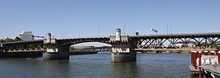
The Broadway Bridge is a Rall-type bascule bridge spanning the Willamette River in Portland, Oregon, United States, built in 1913. It was Portland's first bascule bridge, and it continues to hold the distinction of being the longest span of its bascule design type in the world. It was added to the National Register of Historic Places in November 2012.

The Market Street Bridge, officially referred to as the John Ross Bridge, is a bascule bridge that spans the Tennessee River between downtown Chattanooga, Tennessee, and the Northshore District. It carries North Market Street, and was named in honor of Cherokee Chief John Ross. The bridge was completed in 1917 at a cost of $1.1 million. In the mid-1970s, the southern terminus of US 127 was moved several miles north to the intersection of Dayton Boulevard and Signal Mountain Boulevard in the nearby suburb of Red Bank.
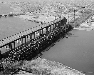
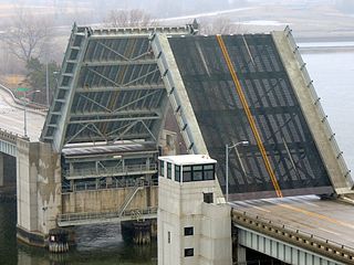
The Charles Berry Bridge, in Lorain, Ohio along U.S. Route 6 (US 6), is the second-largest bascule bridge in the world. It was dedicated on Veterans Day in 1988. The bridge had been built in the late 1930s and in use for roughly 48 years before extensive rehabilitation was finished and the bridge was officially renamed in honor of Lorain native Charles J. Berry, a Marine who was awarded the Medal of Honor for his actions during a minor grenade battle on Iwo Jima.

State Route 531 is an east–west state highway in the U.S. state of Ohio. The western terminus of State Route 531 is at the northern terminus of State Route 534 in Geneva-on-the-Lake, at a curve along Lake Road. The route's eastern terminus is at the northern terminus of State Route 7, at a signalized intersection in Conneaut.

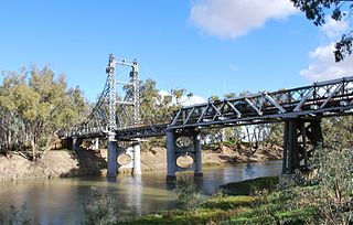
The Grafton Bridge is a heritage-listed bascule truss bridge that carries the Bent Street and North Coast railway line across the Clarence River in Grafton, New South Wales, Australia. The bridge links the Grafton central business district with South Grafton, and was added to the New South Wales State Heritage Register on 2 April 1999.

Harpersfield Bridge is a covered bridge spanning the Grand River in Harpersfield Township, Ashtabula County, Ohio, United States. This double-span Howe truss bridge, one of currently 17 drivable covered bridges in the county, is the third longest covered bridge in Ohio at 228 feet. A flood in 1913 washed away the land at the north end of the bridge, and the steel span was subsequently attached. The bridge features a walkway, added during its renovation in 1991–1992. The bridge also features an Ashtabula County MetroPark at its north end, and is listed on the National Register of Historic Places. The bridge's WGCB number is 35-04-19, and it is located approximately 3.4 miles south of Geneva.

Ashtabula Harbor Light is a lighthouse in Ashtabula, Ohio. It was listed in the National Register on August 8, 1983.
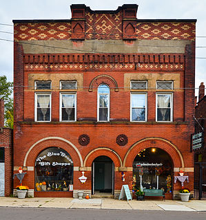
The Ashtabula Harbour Commercial District is a historic district in the northern section of the city of Ashtabula, Ohio, United States. Comprising a commercial section near the city's Lake Erie waterfront, the district includes buildings constructed largely in the late nineteenth century, at which time Ashtabula was a flourishing port city.

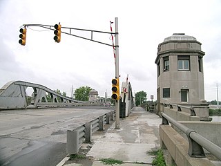
The Lafayette Avenue Bridge, formerly listed on the National Register of Historic Places as the Bay City Bascule Bridge, is the name given to two separate bridges located in Bay City, Michigan. The bridges carry M-13 and M-84 over the Saginaw River. They are maintained by the Michigan Department of Transportation, and the bascule portion is currently the oldest of Bay City's four modern drawbridges. It was listed on the National Register of Historic Places on November 30, 1999, but was removed from the Register in 2015.

The George and Cynthia Mitchell Memorial Causeway is a set of causeways in Galveston, Texas, United States. Two of the routes carry the southbound and northbound traffic of Interstate 45, while the original causeway is restricted to rail traffic. It is the main roadway access point to Galveston Island. The second access point is Bolivar Ferry.
The West Jefferson Avenue–Rouge River Bridge is a bridge located where Jefferson Avenue crosses the Rouge River at the border of Detroit and River Rouge, Michigan. It is the only surviving pony truss bascule bridge in the state of Michigan. It was listed on the National Register of Historic Places in 2000.
The Housatonic River Railroad Bridge is a historic bridge carrying Metro-North Railroad's New Haven Line trackage across the lower Housatonic River in the U.S. state of Connecticut. The bridge is also used by Amtrak for its Northeast Corridor services. It was listed on the National Register of Historic Places in 1987, which also refers to the bridge as the Devon Bridge. It is also referred to as the Devon Railroad Bridge by the state Department of Environmental Protection.

U.S. Route 6 is a part of the United States Numbered Highway System that runs from Bishop, California to Provincetown, Massachusetts. US 6 is the second longest federal highway in the United States, second only to U.S. Route 20. In Ohio, the road runs west-east from the Indiana state line near Edgerton to the Pennsylvania state line near Andover. The 248.002 miles (399.121 km) that lie in Ohio are maintained by the Ohio Department of Transportation (ODOT). US 6 serves the major cities of Sandusky, Lorain, and Cleveland. The highway is also called the Grand Army of the Republic Highway to honor the Union forces of the American Civil War. The alternate name was designated in 1953.

The Amtrak Old Saybrook–Old Lyme Bridge is the last crossing of the Connecticut River before it reaches Long Island Sound. It is a Truss bridge with a bascule span, allowing boat traffic to pass through. The bridge is owned by Amtrak and used by Northeast Regional, Acela Express, Shore Line East and a few freight trains traversing the Northeast Corridor. It can be seen from the Raymond E. Baldwin Bridge, as well as from various points on Route 154.
The Blossomland Bridge is a bascule bridge in St. Joseph, Michigan, that carries M-63 across the St. Joseph River. Delayed by World War II, construction took place from 1947 though 1948. At the time, it was the longest bridge built by the Michigan State Highway Department. The bridge is listed on the National Register of Historic Places.

The Cheboygan Bascule Bridge, also known as the State Street Bridge, is a double-leaf bascule bridge in Cheboygan, Michigan, carrying U.S. Highway 23 across the Cheboygan River. Built in 1940, it was the last bascule bridge constructed in the state of Michigan prior to the end of World War II. It replaced an aging swing bridge built in 1877. The bridge is listed on the National Register of Historic Places.
The Murrumbidgee River bridge, Carrathool is a heritage-listed road bridge that, until its closure in 2019, carried Carrathool Road across the Murrumbidgee River in Carrathool, New South Wales, Australia. The bridge is owned by Transport for NSW. The bridge is also called the Carrathool Bridge over Murrumbidgee River and provides a key connection between the Sturt Highway and the Murrumbidgee Road. It was added to the New South Wales State Heritage Register on 20 June 2000.


