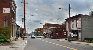
Ashtabula is the most populous city in Ashtabula County, Ohio, United States. It lies at the mouth of the Ashtabula River, on Lake Erie, 53 miles (85 km) northeast of Cleveland. At the 2020 census, the city had 17,975 people. Like many other cities in the Rust Belt, it has lost population because of a decline in industrial jobs since the 1960s. It is part of the Cleveland metropolitan area.
The Greater Richmond, Virginia area has many neighborhoods and districts.

The National Register of Historic Places in the United States is a register including buildings, sites, structures, districts, and objects. The Register automatically includes all National Historic Landmarks as well as all historic areas administered by the U.S. National Park Service. Since its introduction in 1966, more than 97,000 separate listings have been added to the register.
This is a list of properties and historic districts in Washington that are listed on the National Register of Historic Places. There are at least three listings in each of Washington's 39 counties.

The Grand River is a tributary of Lake Erie, 102.7 miles (165.3 km) long, in northeastern Ohio in the United States. Via Lake Erie, the Niagara River and Lake Ontario, it is part of the watershed of the St. Lawrence River, which flows to the Atlantic Ocean. It drains an area of 712 mi² (1844 km²).

The Old West Austin Historic District is a residential community in Austin, Texas, United States. It is composed of three neighborhoods located on a plateau just west of downtown Austin: Old Enfield, Pemberton Heights, and Bryker Woods. Developed between 1886 and 1953, the three historic neighborhoods stretch from Mopac Expressway east to Lamar Boulevard, and from 13th Street north to 35th Street. It borders Clarksville Historic District and the West Line Historic District to the south.

Shockoe Slip is a district in the downtown area of Richmond, Virginia. The name "slip" referred to a narrow passageway leading from Main Street to where goods were loaded and unloaded from the former James River and Kanawha Canal. The rough boundaries of Shockoe Slip include 14th Street, Main Street, Canal Street and 12th Street.

The Old Jeffersonville Historic District is located in Jeffersonville, Indiana, United States. It marks the original boundaries of Jeffersonville, and is the heart of modern-day downtown Jeffersonville. It was placed on the National Register of Historic Places in 1983. The area is roughly bounded by Court Avenue at the North, Graham Street on the east, the Ohio River at the south, and Interstate 65 at the west. In total, the district has 203 acres (0.8 km2), 500 buildings, 6 structures, and 11 objects. Several banks are located in the historic buildings in the district. The now defunct Steamboat Days Festival, held on the second weekend in September, used to be held on Spring Street and the waterfront. Jeffersonville's largest fire wiped out a block in the historic district on January 11, 2004, which destroyed the original Horner's Novelty store.
Columbus, the state capital and Ohio's largest city, has numerous neighborhoods within its city limits. Neighborhood names and boundaries are not officially defined. They may vary or change from time to time due to demographic and economic variables.
The Huffman Historic District is a historic section of the Historic Inner East neighborhood in Dayton, Ohio, United States. Formed at the end of the nineteenth century primarily by a wealthy businessman, it has long been home to people of many different occupations and numerous places on the social ladder. After seeing very few changes throughout the twentieth century, it was named a historic site in the 1980s.

Ashtabula Harbor Light is a lighthouse in Ashtabula, Ohio. It was listed in the National Register on August 8, 1983.

The Ashtabula lift bridge is a Strauss bascule bridge that carries Ohio State Route 531 over the Ashtabula River in the harbor of Ashtabula, Ohio.
Harmar is a historic neighborhood in the city of Marietta, Ohio, United States. Located at the western side of the confluence of the Muskingum and Ohio Rivers, it grew up around the early Fort Harmar in the 1780s, being settled in conjunction with Marietta. After a period of forming part of Marietta, it existed separately beginning in 1837 before rejoining the mother city in 1890. Connected by bridge to the rest of the city, it retains much of its nineteenth-century architecture and landscape, and most of the neighborhood is now a historic district on the National Register of Historic Places.

Mother of Sorrows Catholic Church is a historic Catholic church at 1500 W. 6th Street in Ashtabula, Ohio, United States. It was built in the 1890s for a newly established parish and has gained both local and federal designation as a historic site.

St. Michael's Catholic Church is a historic Catholic church in Mechanicsburg, a village in Champaign County, Ohio, United States. Completed in the 1880s, it served a group of Catholics who had already been meeting together for nearly thirty years. One of several historic churches in the village, it has been designated a historic site because of its well-preserved nineteenth-century architecture.

The Water Street Historic District encompasses a historic commercial and industrial area on the west side of downtown Torrington, Connecticut. Extending roughly along Water and Church Streets between the Naugatuck River and Prospect Street, the district includes factory and commercial buildings, as well as the former Torrington Fire Department Headquarters and the civic Knights of Pythias building. Developed between about 1885 and 1920, the district was listed on the National Register of Historic Places in 2003.

The Steele Dunning Historic District is a neighborhood and historic district in Bloomington, Indiana, United States. Composed of small, single- or double-family houses, the district includes houses built from the late nineteenth century through the middle of the twentieth century.

The Downtown Morgantown Historic District is a federally designated historic district in Morgantown, Monongalia County, West Virginia. The district, encompassing approximately 75 acres, has 122 contributing buildings and 2 contributing sites including commercial and public buildings, residences, and churches. The district has been listed on the National Register of Historic Places since May 2, 1996. Ten of the contributing buildings are listed separately on the National Register of Historic Places. Significant structures located within the historic district are the Monongalia County Courthouse, the Metropolitan Theater, and the Old Morgantown Post Office.
The Hoffner Historic District is a historic collection of buildings in the Northside neighborhood of Cincinnati, Ohio, United States. Built primarily at the end of the nineteenth century, the district has experienced few changes since it was built, and it has been named a historic site.
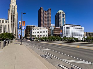
Broad Street is a major thoroughfare in Central Ohio, predominantly in Franklin County and Columbus. It stretches east from West Jefferson at Little Darby Creek to Pataskala. The street is considered one of Columbus's two main roads, along with High Street.


