
Adams County is a county in the U.S. state of Ohio. As of the 2020 census, the population was 27,477. Its county seat and largest village is West Union. The county is named after John Adams, the second President of the United States.
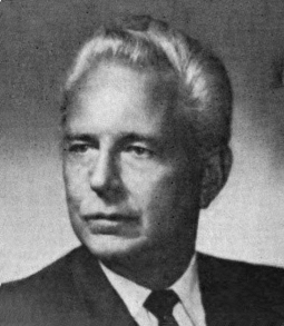
William Howard Harsha Jr. was an American politician who represented Ohio as a Republican in the United States House of Representatives from January 3, 1961, to January 3, 1981.

Adams Township is one of thirteen townships in Parke County, Indiana, United States. As of the 2010 census, its population was 5,825 and it contained 2,062 housing units.

The Newport Southbank Bridge, popularly known as the Purple People Bridge, stretches 2,670 feet over the Ohio River, connecting Newport, Kentucky to downtown Cincinnati, Ohio.
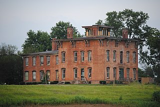
Prospect Place, also known as The Trinway Mansion and Prospect Place Estate is a 29-room mansion built by abolitionist George Willison Adams in Trinway, Ohio, just north of Dresden in 1856. Today, it is the home of the non-profit G. W. Adams Educational Center, Inc. The mansion is listed on the National Register of Historic Places and the Ohio Underground Railroad Association's list of Underground Railroad sites.

This is a list of properties and districts in Ohio that are listed on the National Register of Historic Places. There are over 4.000 in total. Of these, 73 are National Historic Landmarks. There are listings in each of Ohio's 88 counties.

Bartlett is an unincorporated community in southwestern Wesley Township, Washington County, Ohio, United States. It has a post office with the ZIP code 45713. It sits at the intersection of State Routes 550 and 555 near Coal Run, a subsidiary of Wolf Creek, which meets the Muskingum River at Waterford to the north. Near Bartlett is located the Shinn Covered Bridge, which spans Wolf Creek.

Adams Covered Bridge is a 58-foot (18 m) historic covered bridge in Morgan County, Ohio spanning San Toy Creek near Malta. The bridge was built in 1875 using a "multiple kingpost truss" design. It is no longer used for traffic. It has also been known as the San Toy Bridge and as the Adams - San Toy Covered Bridge.
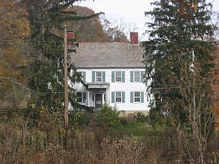
The Adams–Gray House is a historic farmhouse in the community of Adams Mills, Ohio. Constructed in the 1840s in two separate counties, it has been named a historic site.

This is a list of the National Register of Historic Places listings in Brown County, Ohio.

The Lynchburg Covered Bridge is a historic wooden covered bridge that spans the east fork of the Little Miami River in Lynchburg, Ohio. It, also, has the distinction, following a recent repair and restoration project, of being the only such covered bridge in North America to have been converted to a pseudo-suspension infrastructure. The bridge was built in 1870 as a Long truss.

The McColly Covered Bridge is a historic wooden covered bridge in western Logan County, Ohio, United States. Located in Washington Township near the community of Bloom Center, it is one of two remaining covered bridges in Logan County. It carries County Road 13 over the Great Miami River, approximately 5 miles (8.0 km) south of its source at Indian Lake.

The First Universalist Church of Olmsted is a historic Unitarian Universalist church in the city of North Olmsted, Ohio, United States. The second-oldest church building in Cuyahoga County, it has been a community landmark since the middle of the nineteenth century, and it was officially named a historic site in the late twentieth.

The Harra Covered Bridge is a historic wooden covered bridge in Washington County, Ohio, United States. Located in western Watertown Township, about 2 miles (3.2 km) north of the community of Watertown, the bridge spans the South Branch of Wolf Creek near the intersection of State Route 339 and Township Road 172. Among the bridge's more distinctive features are its cut stone abutments, its metal roof, and the vertical siding. Although it has been open for well over one hundred years, it remains in strong structural condition, and it served daily traffic into the late twentieth century.

The Eakin Mill Covered Bridge is a historic covered bridge in Vinton County, Ohio, United States. Located southeast of the county seat of McArthur, this bridge carries Mound Hill Road near the community of Arbaugh.

The Hune Covered Bridge is a historic wooden covered bridge in the southeastern part of the U.S. state of Ohio. Located northeast of the community of Dart, it spans the Little Muskingum River in northeastern Lawrence Township in the eastern part of Washington County. Local bridge builder Rollin Meredith erected it in 1879, using the Long-truss style of truss bridge design; the single-span bridge was named for the locally prominent Hune family. Among its design features are a metal roof, abutments of cut stone, and vertical siding. As a Long truss, the Hune Bridge is a valuable example of nineteenth-century architecture: few examples of this complicated style survive to the present day. In 1976, the Hune Bridge was listed on the National Register of Historic Places, both because of its place in local history and because of its historically significant construction.
The Root Covered Bridge is a historic wooden covered bridge in the southeastern part of the U.S. state of Ohio. Located off State Route 555 in far northern Decatur Township, Washington County, the bridge was built in 1878 in the Long truss mode of truss bridge construction. Measuring 65 feet (20 m) in its single span, it spans the West Branch of the Little Hocking River.

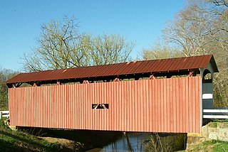
The Harshaville Covered Bridge is a historic covered bridge spanning the Cherry Fork Creek at Harshaville, Adams County, Ohio, United States. Built in 1855, it is a Burr truss bridge with a 110-foot span. It has sheet metal siding, a metal roof and stone abutments. It was listed on the National Register of Historic Places in 1976.

The Ballard Road Covered Bridge is a historic wooden covered bridge in the southwestern part of the U.S. state of Ohio. Built in the late nineteenth century and since bypassed, the bridge has been named a historic site.

The Kidwell Covered Bridge, in Dover Township, Athens County, Ohio between the nearby hamlets of Truetown and Redtown, was built in 1880. It spans Sunday Creek. It was listed on the National Register of Historic Places in 1977.


