Wrightsville, Adams County, Ohio

Last updated

Wrightsville, Ohio
Wrightsville Adams County Ohio.jpg
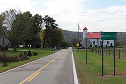
Wrightsville community sign on Ohio State Route 247 South
USA Ohio location map.svg
Red pog.svg
Wrightsville, Ohio
Location of Wrightsville, Ohio
Coordinates: 38°42′10″N83°30′44″W / 38.70278°N 83.51222°W / 38.70278; -83.51222
Country United States
State Ohio
County Adams
Township Monroe
Time zone UTC-5 (Eastern (EST))
  Summer (DST) UTC-4 (EDT)
ZIP codes
45144 (Manchester)
Area code 937
GNIS feature ID1061804

Wrightsville is an unincorporated community in Adams County, in the U.S. state of Ohio. [1]

History

Wrightsville was platted in 1847. [2] The post office Wrightsville once contained was first called Mahala, then Vineyard Hill. [2] The post office was established as Mahala in 1850, the name was changed to Vineyard Hill in 1857, and the post office closed in 1907. [3]

References

  1. U.S. Geological Survey Geographic Names Information System: Wrightsville, Adams County, Ohio
  2. 1 2 Evans, Nelson Wiley; Stivers, Emmons B. (1900). A History of Adams County, Ohio: From Its Earliest Settlement to the Present Time. E B. Stivers. p. 450.
  3. "Adams County". Jim Forte Postal History. Retrieved December 12, 2015.