Dunkinsville, Ohio | |
|---|---|
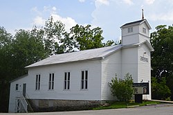 Dunkinsville United Methodist Church | |
 Dunkinsville, Ohio  Dunkinsville, Ohio | |
| Coordinates: 38°51′21″N83°28′17″W / 38.85583°N 83.47139°W | |
| Country | |
| State | |
| County | Adams |
| Elevation | 187 m (614 ft) |
| Time zone | UTC-5 (Eastern (EST)) |
| • Summer (DST) | UTC-4 (EDT) |
| ZIP Code | 45660 |
| Area codes | 937, 326 |
| GNIS feature ID | 1378030 [1] |
Dunkinsville is an unincorporated community in Adams County, in the U.S. state of Ohio. [1]
