Caledonia, Ohio | |
---|---|
Coordinates: 40°38′11″N82°58′10″W / 40.63639°N 82.96944°W | |
Country | United States |
State | Ohio |
County | Marion |
Township | Claridon |
Area | |
• Total | 0.23 sq mi (0.63 km2) |
• Land | 0.23 sq mi (0.63 km2) |
• Water | 0.00 sq mi (0.00 km2) |
Elevation | 997 ft (304 m) |
Population (2020) | |
• Total | 560 |
• Estimate (2023) [3] | 550 |
• Density | 2,434.8/sq mi (933.3/km2) |
Time zone | UTC-5 (Eastern (EST)) |
• Summer (DST) | UTC-4 (EDT) |
ZIP code | 43314 |
Area code | 419 |
FIPS code | 39-10954 [4] |
GNIS feature ID | 2397526 [2] |
Website | http://www.caledonia-village.com |
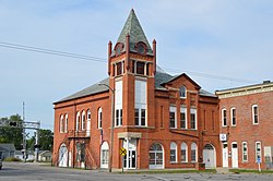
Caledonia is a village in Marion County, Ohio, United States. The population was 560 at the 2020 census.
The village was named after Caledonia, an ancient name for Scotland, the ancestral home of a large share of the first settlers. [5]
The northern side of Caledonia is the location of the Caledonia Bowstring Bridge, which is listed on the National Register of Historic Places. [6]
According to the United States Census Bureau, the village has a total area of 0.23 square miles (0.60 km2), all land. [7]
Caledonia is located along the Whetstone River in the Sandusky Plains: a historically important tended prairie region, & one of only a handful of post-glaciation prairie regions in Ohio.
Census | Pop. | Note | %± |
---|---|---|---|
1870 | 419 | — | |
1880 | 627 | 49.6% | |
1890 | 757 | 20.7% | |
1900 | 682 | −9.9% | |
1910 | 562 | −17.6% | |
1920 | 492 | −12.5% | |
1930 | 526 | 6.9% | |
1940 | 629 | 19.6% | |
1950 | 655 | 4.1% | |
1960 | 673 | 2.7% | |
1970 | 792 | 17.7% | |
1980 | 759 | −4.2% | |
1990 | 644 | −15.2% | |
2000 | 578 | −10.2% | |
2010 | 577 | −0.2% | |
2020 | 560 | −2.9% | |
2023 (est.) | 550 | [3] | −1.8% |
U.S. Decennial Census [8] |
As of the census of 2020, there were 560 people, 246 housing units, 230 households, and 154 families living in the village. The population density was 2,434.8 inhabitants per square mile (940.1/km2). There were 246 housing units at an average density of 1,069.6 units per square mile (413.0 units/km2). The racial makeup of the village was 93.6% White, 0.3% African American, 0.0% Asian, 0.5% from other races, 5.0% from two or more races, and 0.5% American Indian/Alaskan Native. Hispanic or Latino of any race were 1.25% of the population.
There were 230 households, with the average household size being 3.34. 58.0% were married couples living together.
The median age in the village was 32.2 years. 25.9% of residents were under the age of 18; 7.4% were between the ages of 18 and 24; 32.2% were from 25 to 44; 19.9% were from 45 to 64; and 14.8% were 65 years of age or older. The gender makeup of the village was 50.5% male and 49.5% female.
The median income for a household in the village was $64,286, and the median income for a family was $75,625. About 11.7% of the population were living below the poverty line.
As of the census [9] of 2010, there were 577 people, 232 households, and 174 families living in the village. The population density was 2,508.7 inhabitants per square mile (968.6/km2). There were 260 housing units at an average density of 1,130.4 units per square mile (436.4 units/km2). The racial makeup of the village was 97.4% White, 1.6% African American, 0.2% Asian, 0.7% from other races, and 0.2% from two or more races. Hispanic or Latino of any race were 0.5% of the population.
There were 232 households, of which 31.5% had children under the age of 18 living with them, 57.3% were married couples living together, 12.1% had a female householder with no husband present, 5.6% had a male householder with no wife present, and 25.0% were non-families. 21.1% of all households were made up of individuals, and 10.3% had someone living alone who was 65 years of age or older. The average household size was 2.49 and the average family size was 2.86.
The median age in the village was 40.2 years. 24.1% of residents were under the age of 18; 6.6% were between the ages of 18 and 24; 26% were from 25 to 44; 27.2% were from 45 to 64; and 16.3% were 65 years of age or older. The gender makeup of the village was 47.5% male and 52.5% female.
As of the census [4] of 2000, there were 578 people, 230 households, and 169 families living in the village. The population density was 2,568.0 inhabitants per square mile (991.5/km2). There were 242 housing units at an average density of 1,075.2 units per square mile (415.1 units/km2). The racial makeup of the village was 99.31% White, 0.35% African American, and 0.35% from two or more races. Hispanic or Latino of any race were 0.35% of the population.
There were 230 households, out of which 32.6% had children under the age of 18 living with them, 60.0% were married couples living together, 8.7% had a female householder with no husband present, and 26.5% were non-families. 23.9% of all households were made up of individuals, and 12.2% had someone living alone who was 65 years of age or older. The average household size was 2.51 and the average family size was 2.92.
In the village, the population was spread out, with 25.3% under the age of 18, 7.1% from 18 to 24, 30.3% from 25 to 44, 25.4% from 45 to 64, and 11.9% who were 65 years of age or older. The median age was 37 years. For every 100 females there were 95.9 males. For every 100 females age 18 and over, there were 97.3 males.
The median income for a household in the village was $40,804, and the median income for a family was $46,563. Males had a median income of $34,375 versus $22,344 for females. The per capita income for the village was $17,423. About 1.9% of families and 4.9% of the population were below the poverty line, including none of those under age 18 and 5.3% of those age 65 or over.
River Valley Local School District operates two elementary schools, one middle school, and River Valley High School. [10]
From the 1920s until 2021, Caledonia had a public library: a branch of Marion Public Library. This branch closed in the middle of the COVID-19 pandemic, & does not have plans to reopen. The library space is currently vacant. [11]
Caledonia is a village in Kent County in the U.S. state of Michigan. The population was 1,622 at the 2020 census. The village is located within Caledonia Township about 15 miles (24.1 km) southeast of downtown Grand Rapids.
Caledonia is a city and the county seat of Houston County, Minnesota, United States and is part of the La Crosse, Wisconsin Metropolitan Statistical Area. The population was 2,847 at the 2020 census.
River Bend is a village in Jackson County, Missouri, United States. The population was 3 at the 2020 census. It is the only part of Jackson County that lies north of the Missouri River. In 1951, the Missouri River was relocated to a new channel, creating River Bend,. The county line still follows the original riverbed. It is part of the Kansas City metropolitan area. The mayor is Alex Dockler.
Evergreen is a village in Laclede County, Missouri, United States. The population was 28 at the 2010 census. It was named Twin Bridges at the 2000 census.
Mackenzie is an unincorporated community in St. Louis County, Missouri, United States. The population was 134 at the 2010 census.
Westwood is a village in west St. Louis County, Missouri, United States. The population was 316 at the 2020 census.
Caledonia is a village in southern Washington County, Missouri, United States. The population was 131 at the 2020 census. Caledonia is located 4 miles (6.4 km) east of Belgrade.
Palestine is a village in Darke County, Ohio, United States. The population was 180 at the 2020 census.
Tarlton is a village in Fairfield and Pickaway counties in the U.S. state of Ohio. The population was 254 at the 2020 census.
Harpster is a village in Wyandot County, Ohio, United States. The population was 160 at the 2020 census.
Bethlehem is a village in Ohio County, West Virginia, United States. It is part of the Wheeling, West Virginia Metropolitan Statistical Area. The population was 2,499 at the 2010 census.
Bellevue is a village in Brown County, Wisconsin. It was a town until incorporating as a village on February 14, 2003. The population was 15,935 at the time of the 2020 census. Bellevue is part of the Green Bay metropolitan area. Bellevue sits around 4.34 miles (6.99 km) east from central Green Bay.
Kekoskee is a village in Dodge County, Wisconsin, United States. The population was 161 at the 2010 census.
Avoca is a village in Iowa County, Wisconsin, United States. The population was 637 at the 2010 census. It is part of the Madison Metropolitan Statistical Area. It is named after Avoca in Ireland.
Bay City is a village on the Mississippi River in Pierce County, Wisconsin, United States. The population was 500 at the 2010 census.
Caledonia is a town in Waupaca County, Wisconsin, United States. The population was 1,712 at the 2020 census. The unincorporated communities of North Readfield and Readfield are located in the town.
Wilson is a village in Belmont and Monroe counties in the U.S. state of Ohio. The population was 129 at the 2020 census. It is part of the Wheeling metropolitan area.
Verona is a village in Montgomery and Preble counties in the U.S. state of Ohio. The population was 403 at the 2020 census. It is part of the Dayton Metropolitan Statistical Area.
Dallas is a village in Barron County in the U.S. state of Wisconsin. The population was 409 at the 2010 census. The village is located within the Town of Dallas.
Lowell is a village in Dodge County, Wisconsin, United States, along the Beaver Dam River. The population was 340 at the 2010 census. The village is located within the Town of Lowell.