
The Auglaize River is a 113-mile-long (182 km) tributary of the Maumee River in northwestern Ohio in the United States. It drains a primarily rural farming area in the watershed of Lake Erie. The name of the river was derived from the French term for it. The French called it "rivière à la Grande Glaize", referring to the soil in the area.

The Smith River flows from the Klamath Mountains to the Pacific Ocean in Del Norte County in extreme northwestern California, on the West Coast of the United States. The river, about 25.1 miles (40.4 km) long, all within Del Norte County, flows through the Rogue River – Siskiyou National Forest, Six Rivers National Forest, and Jedediah Smith Redwoods State Park.

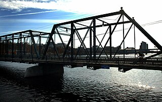
A truss bridge is a bridge whose load-bearing superstructure is composed of a truss, a structure of connected elements, usually forming triangular units. The connected elements, typically straight, may be stressed from tension, compression, or sometimes both in response to dynamic loads. There are several types of truss bridges, including some with simple designs that were among the first bridges designed in the 19th and early 20th centuries. A truss bridge is economical to construct primarily because it uses materials efficiently.

The Ohio and Erie Canal was a canal constructed during the 1820s and early 1830s in Ohio. It connected Akron with the Cuyahoga River near its outlet on Lake Erie in Cleveland, and a few years later, with the Ohio River near Portsmouth. It also had connections to other canal systems in Pennsylvania.

Pennypack Creek is a 22.6-mile-long (36.4 km) creek in southeastern Pennsylvania in the United States. It runs southeast through lower Bucks County, eastern Montgomery County and the northeast section of Philadelphia, before emptying into the Delaware River.

The Delaware River is a 94-mile-long (151 km) river located in the northeastern part of the state of Kansas. The Delaware River basin drains 1,117 square miles (2,890 km2) from the outflow of the Perry Lake reservoir. The river has been classified as a Category 1 watershed by the Kansas Department of Health and Environment, meaning that the watershed is in need of immediate restoration and protection. The river is one of the major tributaries of the Kansas River.

German Township is one of the twelve townships in Fulton County, Ohio, United States. The 2020 census found 6,576 people in the township.
The Beech Fork, or Beech Fork River, is a 112-mile-long (180 km) river in central Kentucky in the United States. It is a tributary of the Rolling Fork of the Salt River, with its waters flowing eventually to the Ohio River and ultimately the Mississippi River.

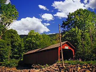
The Cogan House Covered Bridge is a Burr arch truss covered bridge over Larrys Creek in Cogan House Township, Lycoming County, in the U.S. state of Pennsylvania. It was built in 1877 and is 94 feet 2 inches (28.7 m) long. The bridge was placed on the National Register of Historic Places in 1980 and underwent a major restoration in 1998. The Cogan House bridge is named for the township and village of Cogan House, and is also known by at least four other names: Buckhorn, Larrys Creek, Day's, and Plankenhorn.
The Sonestown Covered Bridge is a covered bridge over Muncy Creek in Davidson Township, Sullivan County, Pennsylvania built around 1850. It is 110 ft (34 m) long and was placed on the National Register of Historic Places (NRHP) in 1980. It is named for the nearby unincorporated village of Sonestown in Davidson Township, and is also known as the Davidson Covered Bridge. It was built to provide access to a grist mill which operated until the early 20th century.

The Harra Covered Bridge is a historic wooden covered bridge in Washington County, Ohio, United States. Located in western Watertown Township, about 2 miles (3.2 km) north of the community of Watertown, the bridge spans the South Branch of Wolf Creek near the intersection of State Route 339 and Township Road 172. Among the bridge's more distinctive features are its cut stone abutments, its metal roof, and the vertical siding. Although it has been open for well over one hundred years, it remains in strong structural condition, and it served daily traffic into the late twentieth century.

The Whipple Cast and Wrought Iron Bowstring Truss Bridge, is located near the entrance to Stevens Farm in southwestern Albany, New York, United States. It was built in 1867, but not moved to its present location until 1899. It is one of the oldest surviving iron bridges in the county, one of the few that use both cast and wrought iron and one of only two surviving examples of the Whipple bowstring truss type. In 1971 it was listed on the National Register of Historic Places, the only bridge in the city of Albany so far to be listed individually.
The Massillon Bridge Company, most commonly abbreviated Massillon Bridge Co., was located in Massillon, Ohio and founded by Joseph Davenport in 1869. The company became incorporated in 1887 and remained in operation through the early 1900s. Steel truss bridges built by the Massillon Bridge Co. can be found throughout the midwest.

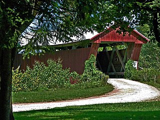
The Ballard Road Covered Bridge is a historic wooden covered bridge in the southwestern part of the U.S. state of Ohio. Built in the late nineteenth century and since bypassed, the bridge has been named a historic site.

The East Bloomsburg Bridge was a bridge in Bloomsburg, Pennsylvania, in the United States. It carried the traffic of Pennsylvania Route 487, which is known as Ferry Road at that point. The bridge crossed the Susquehanna River. It was built in 1894 and torn down in 1987. The East Bloomsburg Bridge is on the Historic American Engineering Record and the Historic American Buildings Survey, as of 1992.

The Capon Lake Whipple Truss Bridge, formerly known as South Branch Bridge or Romney Bridge, is a historic Whipple truss bridge in Capon Lake, West Virginia. It is located off Carpers Pike and crosses the Cacapon River. The bridge formerly carried Capon Springs Road over the river, connecting Capon Springs and Capon Lake.

U.S. Route 60 and U.S. Route 62 (US 60/US 62) run for a very short distance within the state of Illinois. The highways run concurrently for their entire existence within the state. The joint highway runs around Fort Defiance in Cairo, from the Cairo Mississippi River Bridge over the Mississippi River east to the Cairo Ohio River Bridge over the Ohio River; the Ohio River Bridge also carries US 51. The bridges cross the two rivers just north of the mouth of the Ohio.
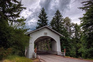
Thomas Creek is a stream, about 35 miles (56 km) long, in Linn County in the U.S. state of Oregon. Beginning in Willamette National Forest on the western slopes of the Cascade Range, the creek flows generally west through Santiam State Forest and farmland to meet the South Santiam River west of Scio.
The Johnson Road Covered Bridge is a covered bridge located near Petersburg, Jackson County, Ohio, United States.
Reuben L. Partridge was an American pioneer and engineer in Union County, Ohio, known locally as "The Bridge Builder".


