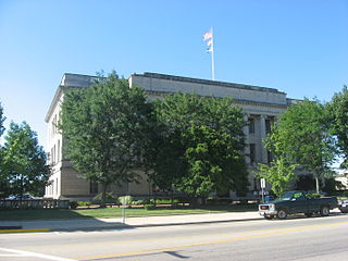
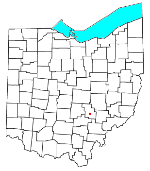
Preble County is a county located in the U.S. state of Ohio. As of the 2020 census, the population was 40,999, down 3.0% from the 2010 census population of 42,270. Its county seat is Eaton. The county was formed on February 15, 1808, from portions of Butler and Montgomery Counties. It is named for Edward Preble, a naval officer who fought in the American Revolutionary War and against the Barbary Pirates.

Lees Creek, also known as Centerville, is an unincorporated community in central Wayne Township, Clinton County, Ohio, United States. It lies at the intersection of State Route 729 with Cox Road, 6 miles south of Sabina and 12 miles (19 km) southeast of Wilmington, the county seat of Clinton County. It lies between the headwaters of the Middle Fork of Lees Creek, to the southeast, and the Anderson Fork of Caesar Creek. it had a post office, with the ZIP code 45138. The Post Office closed in 2012 and the town, including East Clinton High School, now carries a Sabina mailing address.

Roundhead is an unincorporated community in southeastern Roundhead Township, Hardin County, Ohio, United States. It has a post office with the ZIP code 43346.

Haydenville is an unincorporated community and census-designated place (CDP) in southern Green Township, Hocking County, Ohio, United States. As of the 2020 census the population of the CDP was 337.
Springhills is an unincorporated community in northwestern Harrison Township, Champaign County, Ohio, United States. It lies at the intersection of State Route 245 with Crowl and Springhill-DeGraff Roads. Graves Creek, a subsidiary of the Great Miami River through Stony Creek, runs along the western edge of Springhills. It is located 6 miles (9.5 km) west of West Liberty and 11.5 miles (18.5 km) northwest of Urbana, the county seat of Champaign County.

Pyrmont is an unincorporated community in northwestern Perry Township, Montgomery County, Ohio, United States. It centers at the intersection of Brookville–Pyrmont Pike and Sulphur Springs Road, extending to the intersection of Brookville–Pyrmont Pike and Providence Pike. Located in the far west of the county, it lies several miles from the city of Dayton; the nearest city is Brookville, three miles to the northeast. Pyrmont is a part of the Brookville Local School District. Pyrmont, which was on a stagecoach route, was a busy town before Interstate 70 was built near Brookville.

Williams Center is an unincorporated community in southeastern Center Township, Williams County, Ohio, United States. It lies at the intersection of State Routes 2 and 576. The headwaters of the Little Lick Creek, a subsidiary of the Maumee River through Lick Creek and the Tiffin River, are located around Williams Center. It is located 4¼ miles southwest of Bryan, the county seat of Williams County.

Marshall is an unincorporated community in central Marshall Township, Highland County, Ohio, United States. It lies at the intersection of State Routes 124 and 506. Rocky Fork Lake, the site of Rocky Fork State Park, is located 2 miles (3 km) to the north. It lies 7 miles (11 km) east-southeast of the city of Hillsboro, the county seat of Highland County. An early variant name was West Liberty.
Bristol is an unincorporated community in southern Pike Township, Perry County, Ohio, United States. It lies along State Route 93 at its intersection with Marietta Road and Township Road 223. It is located 4 miles south of New Lexington, the county seat of Perry County.

Harriettsville is an unincorporated community in western Elk Township, Noble County, Ohio, United States. It lies along State Route 145 at its intersection with County Road 46. The East Fork of Duck Creek, a subsidiary of the Ohio River that meets the river near Marietta, runs along State Route 145 past the community. It lies 8 miles (13 km) northeast of Lower Salem by road, and 13 miles (21 km) directly southeast of Caldwell, the county seat of Noble County.
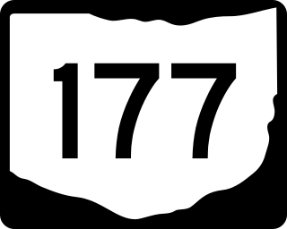
State Route 177 is a north–south state highway located in the southwest corner of the U.S. state of Ohio. The southern terminus of State Route 177 is at the signalized junction of State Route 4 and State Route 129 in Hamilton, after State Route 177 runs concurrently with State Route 129 for its southernmost 1.59 miles (2.56 km). The northern terminus of State Route 177 is at the Indiana State Line approximately 3.75 miles (6.04 km) northwest of the unincorporated community of Fairhaven. From this point, State Route 177 continues into Indiana as Indiana State Road 227.
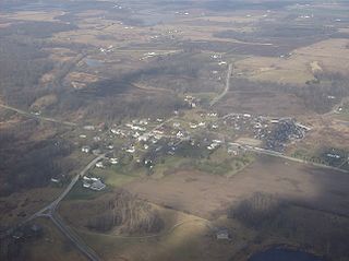
Morning Sun is an unincorporated community in southeastern Israel Township, Preble County, Ohio, United States. It is located approximately 3.5 miles (5.6 km) south of Fairhaven at the intersection of State Routes 177 and 732 with Morning Sun Road, just north of Hueston Woods State Park. The community is part of the Dayton Metropolitan Statistical Area.

Montra is an unincorporated community in Jackson Township, Shelby County, Ohio, United States. Established in the middle of the nineteenth century, the small community is prominent because of a landmark church, Emanuel Lutheran Church of Montra.

Cassella is an unincorporated community in Marion Township, Mercer County, Ohio, United States. Located at 40°24′22″N84°33′8″W, it lies at an elevation of 955 feet (291 m). Situated at the intersection of State Route 119 and Cassella-Montezuma Road in western Marion Township, it lies in the headwaters of Beaver Creek to the south of the city of Celina, the county seat of Mercer County. Other nearby communities include Maria Stein, 3 miles (4.8 km) to the east, Carthagena, 2 miles (3.2 km) to the north, and St. Henry, 4 miles (6.4 km) to the west.
Enterprise is an unincorporated community in Preble County, in the U.S. state of Ohio.

Gettysburg is an unincorporated community in Preble County, in the U.S. state of Ohio. The National Trail Local School K-12 complex is located on U.S. Route 40 in Gettysburg.
Hamburg is an unincorporated community in Preble County, in the U.S. state of Ohio.
Dadsville is an unincorporated community in Preble County, in the U.S. state of Ohio.
Wheatville is an unincorporated community in Preble County, in the U.S. state of Ohio.

The Roberts Covered Bridge is a Burr Truss covered bridge in Preble County, Ohio near Eaton. It was built in 1829, and was listed on the National Register of Historic Places in 1971.


