
Watson Mill Bridge State Park is a 1,018-acre (4.12 km2) Georgia state park located near Comer and Carlton on the South Fork of the Broad River. The park is named for the Watson Mill Bridge the longest original-site covered bridge in Georgia, which spans 229 feet (70 m) across the South Fork of the Broad River. The site is listed on the National Register of Historic Places as the Watson Mill Covered Bridge and Mill Historic District. The bridge, built in 1885, is supported by a Town lattice truss system held together with wooden pegs also known as trunnels. Georgia once had over 200 covered bridges, but only 20 now remain. The park also offers a scenic nature trail and a new hiking/riding trail that winds through the thick forests and along the rivers edge.

The Carrollton Covered Bridge, in Barbour County, West Virginia, U.S., is the second longest and third oldest surviving covered bridge in the state. The wooden bridge spans the Buckhannon River near Carrollton and was built in 1856 by Emmet J. O'Brien and Daniel O'Brien. It carried the Middle Fork Turnpike, an important connecting road between the Staunton and Parkersburg Turnpike and a road to Clarksburg. The bridge carries West Virginia Route 36.

The Mansfield Covered Bridge is a Double Burr Arch double span truss bridge located on Mansfield Road (historic) and Big Raccoon Creek in Mansfield southeast of Rockville in Parke County, Indiana. Built by Joseph J. Daniels in 1867 at a cost of $12,200. At 279 ft (85 m) it is the second longest covered bridge left in Parke County. This Historic Site rest on land provided by Indiana DNR, of Parke County, Indiana and is open to the public all year.
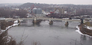
The Zanesville Y-Bridge is a historic Y-shaped three-way bridge that spans the confluence of the Licking and Muskingum Rivers in downtown Zanesville, Ohio. It carries the traffic of U.S. Route 40, as well as Linden Avenue.

The Lynchburg Covered Bridge is a historic wooden covered bridge that spans the east fork of the Little Miami River in Lynchburg, Ohio. It also has the distinction, following a recent repair and restoration project, of being the only such covered bridge in North America to have been converted to a pseudo-suspension infrastructure. The bridge was built in 1870 as a Long truss.

The Williams Bridge is a historic wooden covered bridge built in 1884, located in southern Indiana.

The Lockington Covered Bridge was a historic covered bridge that once spanned the Great Miami River near Lockington, Ohio, United States. Built in 1848, it employed the Long Truss method of construction. Construction elements included vertical wooden siding, wooden structural elements, wooden shingles on its roof, and cut stone abutments. Measuring approximately 170 feet (52 m) long, the bridge was composed of two spans; it cost $1,500 to build.
The Shinn Covered Bridge is a historic wooden covered bridge in the southeastern part of the U.S. state of Ohio. Located in the countryside northeast of Bartlett in Washington County, this single-span truss bridge was built in 1886 by local carpenter Charles T. Shinn. Built of weatherboarded walls with stone abutments and a metal roof, the bridge features vertical siding, and its portals have remained vertical and resisted creeping into another shape. The heart of the bridge's structure employs the Burr Truss design, which mixes the king post truss with a wooden arch designed by Andrea Palladio in the sixteenth century. Shinn built his bridge to span the western branch of Wolf Creek in Palmer Township. Measuring 98 feet (30 m) in length, the bridge was constructed soon after the drowning of one of Shinn's children.
The Root Covered Bridge is a historic wooden covered bridge in the southeastern part of the U.S. state of Ohio. Located off State Route 555 in far northern Decatur Township, Washington County, the bridge was built in 1878 in the Long truss mode of truss bridge construction. Measuring 65 feet (20 m) in its single span, it spans the West Branch of the Little Hocking River.

The Lower Cox Brook Covered Bridge is a wooden covered bridge that crosses Cox Brook in Northfield, Vermont on Cox Brook Road. Built in 1872, it is one of five surviving 19th-century covered bridges in the town, in the only place in Vermont where two historic bridges are visible from each other. It was listed on the National Register of Historic Places in 1974.
The Hopkins Covered Bridge is a wooden covered bridge that crosses the Trout River in Enosburg, Vermont on Hopkins Bridge Road. Built in 1875 by brothers Sheldon & Savannah Jewett, it is one of a cluster of area covered bridges all attributed to the same builders. It was listed on the National Register of Historic Places in 1974.

The Mull Covered Bridge is a historic wooden covered bridge in the northwestern portion of the U.S. state of Ohio. Built in the middle of the nineteenth century, it is located near Burgoon in Sandusky County. Although it is no longer used to facilitate transportation, the bridge has been preserved and is now a historic site.
The Champion Bridge Company, formerly known as Champion Iron Bridge and Manufacturing Company, is a steel fabrication business based in Wilmington, Ohio, in the United States. It has been in business since the 1870s, and several of its works are listed on the National Register of Historic Places.

The Harshaville Covered Bridge is a historic covered bridge spanning the Cherry Fork Creek at Harshaville, Adams County, Ohio, United States. Built in 1855, it is a Burr truss bridge with a 110-foot span. It has sheet metal siding, a metal roof and stone abutments. It was listed on the National Register of Historic Places in 1976.
The South Dakota Department of Transportation Bridge No. 63-052-030 is a historic bridge in rural Turner County, South Dakota, carrying 271st Street across the West Fork Vermillion River northwest of Marion. Built in 1913, it is the longest surviving bridge built for the county by the Federal Bridge Company of Iowa. IIt was listed on the National Register of Historic Places in 1999.
South Dakota Department of Transportation Bridge No. 63-198-181 was a historic bridge in rural Turner County, South Dakota, carrying 460th Avenue across the East Fork Vermillion River south of Davis. Built in 1909, it was a well-preserved example of bridges built for the county by the Iowa Bridge Company. It was listed on the National Register of Historic Places in 1999.

South Dakota Department of Transportation Bridge No. 63-210-282 was a historic bridge in rural Turner County, South Dakota, carrying 461st Avenue across the East Fork Vermillion River southwest of Centerville. Built in 1909, it was a well-preserved example of bridges built for the county by the Iowa Bridge Company. It was listed on the National Register of Historic Places in 1999. The bridge's original Pratt through main span was replaced by a steel girder span in 2009–10.

The Byer Covered Bridge, on SR 31 in Byer, Ohio, is a covered bridge built in c.1870. It was listed on the National Register of Historic Places in 1975. It has a Smith truss span.

The Martinsville Road Covered Bridge, west of Martinsville, Ohio in Clark Township, Clinton County, Ohio, was built in 1871. It was listed on the National Register of Historic Places in 1974.
The Reed Bridge, near Marysville, Ohio, was a Partridge truss covered bridge. It was listed on the National Register of Historic Places in 1975.

