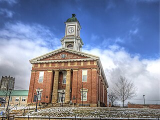
Knox County is a county located in the U.S. state of Ohio. As of the 2020 census, the population was 62,721. Its county seat is Mount Vernon. The county is named for Henry Knox, an officer in the American Revolutionary War who was later the first Secretary of War. Knox County comprises the Mount Vernon, OH Micropolitan Statistical Area, which is also included in the Columbus-Marion-Zanesville, OH Combined Statistical Area.

Florence-Graham is a census-designated place in Los Angeles County, California. The population was 61,983 at the 2020 census, down from 63,387 at the 2010 census. The census area includes separate communities of Florence, Firestone Park, and Graham. It is located in the south central region of Los Angeles County. The neighboring communities are Central-Alameda, Florence, Green Meadows, Lynwood, Vernon, Walnut Park, Watts, and Compton.

Bladensburg is a town in Prince George's County, Maryland, United States. The population was 9,657 at the 2020 census. Areas in Bladensburg are located within ZIP code 20710. Bladensburg is 8.6 miles (13.8 km) from Washington, D.C.

Langley Park is an unincorporated area and census-designated place (CDP) in Prince George's County, Maryland, United States. It is located inside the Capital Beltway, on the northwest edge of Prince George's County, bordering Montgomery County. Per the 2020 census, the population was 20,126.

Burlington is an unincorporated community and census-designated place in Lawrence County, Ohio, United States, along the Ohio River. The population was 2,416 at the 2020 census. Connected to neighboring Huntington, West Virginia and connected via the West Huntington Bridge over the Ohio River, it is part of the Huntington–Ashland metropolitan area. Burlington was once the leading community of Lawrence County, being the first county seat and the location of the county's first post office.

Springfield is a census-designated place (CDP) in Fairfax County, Virginia, United States. The Springfield CDP is recognized by the U.S. Census Bureau with a population of 31,339 as of the 2020 census. Previously, per the 2010 census, the population was 30,484. Homes and businesses in bordering CDPs including North Springfield, West Springfield, and Newington are usually given a Springfield mailing address. The population of the collective areas with Springfield addresses is estimated to exceed 100,000. The CDP is a part of Northern Virginia, the most populous region of the Washington Metropolitan Area.

Howard is a census-designated place (CDP) in southern Howard Township, Knox County, Ohio, United States. As of the 2020 census it had a population of 246. The United States Postal Service has assigned Howard the ZIP Code 43028. The community lies along U.S. Route 36.
Landover is an unincorporated community and census-designated place in Prince George's County, Maryland, United States. As of the 2020 census, it had a population of 25,998.

Islip is a hamlet and census-designated place (CDP) that lies within the town of the same name in Suffolk County, New York. Located on the south shore of Long Island, the CDP had a population of 18,869 at the time of the 2010 census, a decline of 8% from the 2000 census.
McConnellstown is a census-designated place in Walker Township, Huntingdon County, Pennsylvania, United States. Due to its long name, the village is often nicknamed "Mactown". The population of McConnellstown was 1,194 as of the 2010 census.

Haydenville is an unincorporated community and census-designated place (CDP) in southern Green Township, Hocking County, Ohio, United States. As of the 2020 census the population of the CDP was 337.
Rosharon, is an unincorporated community and census-designated place (CDP) located entirely in Brazoria County, Texas, United States, at the intersection of Farm to Market Road 521 and Farm to Market Road 1462. As of the 2010 census, it had a population of 1,152. There are areas outside of the CDP, with Rosharon postal addresses, in Fort Bend County.
Ezel is an unincorporated community and census-designated place (CDP) in Morgan County, Kentucky, United States. As of the 2020 census, it had a population of 209. It has a small post office, with the ZIP code 41425.

Brookside is a historic unincorporated community and census-designated place (CDP) located within Mendham Township in Morris County, in the U.S. state of New Jersey. It is located approximately 6 mi (9.7 km) west of Morristown. It is close to the Washington Valley Historic District in neighboring Morris Township.
Waverly is a census-designated place (CDP) in northeastern Wood County, West Virginia, United States. As of the 2010 census, its population was 395. It lies along the Ohio River on West Virginia Route 2, northeast of the city of Parkersburg, the county seat of Wood County. Its elevation is 620 feet (189 m). It has a post office with the ZIP code 26184.

Hayden is an unincorporated community and census-designated place (CDP) in central Spencer Township, Jennings County, Indiana, United States. As of the 2020 census it had a population of 501.

Butlerville is an unincorporated community and census-designated place (CDP) in central Campbell Township, Jennings County, Indiana, United States. As of the 2010 census it had a population of 282.
Glen Wilton is a census-designated place (CDP) in northern Botetourt County, Virginia, United States. The population was 129 at the 2020 census. The CDP is located along the James River, between Eagle Rock and Iron Gate. It is part of the Roanoke Metropolitan Statistical Area.

Cascades is a census-designated place (CDP) in Loudoun County, Virginia, United States. The population as of the 2010 United States Census was 11,912. Along with nearby Countryside and Lowes Island, it is considered one of the three main components of the Potomac Falls community within Sterling, Virginia.
Stewartsville is a census-designated place (CDP) in southwestern Bedford County, Virginia, United States. The population as of the 2020 census was 533. The CDP is located along State Route 24, between Vinton and Chamblissburg. It is part of the Lynchburg Metropolitan Statistical Area.


