Mount Horeb Earthworks Complex

Last updated
Mount Horeb Earthworks Complex
Mount Horeb Site 1 HRoe 2022 350px.jpg
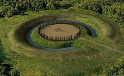
Artists conception of Mount Horeb Site 1
USA Kentucky location map.svg
Archaeological site icon (red).svg
Location within Kentucky today
Location Lexington, Kentucky,  Fayette County, Kentucky, Flag of the United States.svg  USA
Region Fayette County, Kentucky
Coordinates 38°9′32″N84°27′56″W / 38.15889°N 84.46556°W / 38.15889; -84.46556
History
Cultures Adena culture
Site notes
Excavation dates1939
Archaeologists William S. Webb
Architecture
Architectural styles Earthworks, causewayed ring ditch, timber circle

The Mount Horeb Earthworks Complex is an Adena culture group of earthworks in Lexington, Kentucky. It consists of two major components, the Mount Horeb Site 1 and the Peter Village enclosure, and several smaller features including the Grimes Village site, Tarleton Mound, and Fisher Mound. [1] The Peter Village and Grimes Village enclosures were mapped by Rafinesque and featured in Squier and Davis's landmark publication Ancient Monuments of the Mississippi Valley in 1848 as Plate XIV Figures 3 and 4. [2]

Contents

Mount Horeb Site 1

This site is the center piece of the University of Kentucky's Adena Park and is located on a bank 75 feet (23 m) above Elkhorn Creek. It features a causewayed ring ditch with a circular 105-foot (32 m) diameter platform, surrounded by a 45-foot (14 m) wide ditch and a 13-foot (4.0 m) wide enclosure with a 33-foot (10 m) wide entryway facing to the west. In 1939 the site was excavated by William S. Webb and the Works Projects Administration. They discovered the postholes of a circular wooden structure on the platform, which Webb speculated was a ceremonial center for a nearby clan. [1] The 48.5 feet (14.8 m) timber circle was made up of 132 posts, 62 "paired" posts and 8 single posts. [3] In 1936 the site and 6 acres (2.4 hectares) were paid for through private donations and transferred to the Kentucky Archaeological Society. It is currently owned and operated by the University of Kentucky as part of the Campus Recreation Department. [1]

Peter Village enclosure

The earliest occupation at this site is 300 to 200 BCE and is considered to be a pre-Adena site for harvesting and processing galena, which occurs naturally nearby. At this time the site had an earthen enclosure and a palisade and later a 2-meter (6.6 ft) deep ditch. [4] Rafinesque described the site as a twenty sided icosogonal polygon 3,767 feet (1,148 m) long with a 15 feet (4.6 m) wide 4 feet (1.2 m) to 8 feet (2.4 m) deep ditch surrounding it. An entryway to the enclosure was located to the south. [1]

Images in Squier and Davis

Mount Horeb, described as "ancient work near Lexington, Kentucky," was featured in the 1848 book Ancient Monuments of the Mississippi Valley by Ephraim George Squier and Edwin Hamilton Davis. [5]

See also

Related Research Articles

<span class="mw-page-title-main">Serpent Mound</span> Prehistoric effigy mound in Ohio, United States

The Great Serpent Mound is a 1,348-foot-long (411 m), three-foot-high prehistoric effigy mound located in Peebles, Ohio. It was built on what is known as the Serpent Mound crater plateau, running along the Ohio Brush Creek in Adams County, Ohio. The mound is the largest serpent effigy in the world.

<span class="mw-page-title-main">Hopewell Culture National Historical Park</span> United States national historical park

Hopewell Culture National Historical Park is a United States national historical park with earthworks and burial mounds from the Hopewell culture, indigenous peoples who flourished from about 200 BC to AD 500. The park is composed of six separate sites in Ross County, Ohio, including the former Mound City Group National Monument. The park includes archaeological resources of the Hopewell culture. It is administered by the United States Department of the Interior's National Park Service.

<i>Ancient Monuments of the Mississippi Valley</i> Book by Ephraim George Squier

Ancient Monuments of the Mississippi Valley (1848) by the Americans Ephraim George Squier and Edwin Hamilton Davis is a landmark in American scientific research, the study of the prehistoric indigenous mound builders of North America, and the early development of archaeology as a scientific discipline. Published in 1848, it was the Smithsonian Institution's first publication and the first volume in its Contributions to Knowledge series. The book had 306 pages, 48 lithographed maps and plates, and 207 wood engravings. The book was reissued in 1998 in paperback, with an introduction by David J. Meltzer, professor of anthropology at Southern Methodist University.

<span class="mw-page-title-main">Fortified Hill Works</span> Archaeological site in Ohio, United States

Fortified Hill Works is a registered historic site near Hamilton, Ohio, listed in the National Register on July 12, 1974.

<span class="mw-page-title-main">Newark Earthworks</span> Archaeological site in Ohio, United States

The Newark Earthworks in Newark and Heath, Ohio, consist of three sections of preserved earthworks: the Great Circle Earthworks, the Octagon Earthworks, and the Wright Earthworks. This complex, built by the Hopewell culture between 100 BCE and 400 CE, contains the largest earthen enclosures in the world, and was about 3,000 acres in total extent. Less than 10 percent of the total site has been preserved since European-American settlement; this area contains a total of 206 acres (83 ha). Newark's Octagon and Great Circle Earthworks are managed by the Ohio History Connection. A designated National Historic Landmark, in 2006 the Newark Earthworks was also designated as the "official prehistoric monument of the State of Ohio."

<span class="mw-page-title-main">Hopeton Earthworks</span> United States historic place

The Hopeton Earthworks are an Ohio Hopewell culture archaeological site consisting of mounds and earthwork enclosures. It is located on the eastern bank of the Scioto River just north of Chillicothe in Ross County, Ohio, about 1 mile (1.6 km) east of the Mound City Group and Shriver Circle on a terrace of the Scioto River. The site is a detached portion of the Hopewell Culture National Historic Park, along with the Mound City Group, Hopewell Mound Group, Seip Earthworks, Spruce Hill Earthworks and the High Bank Works. The site is open to the public.

<span class="mw-page-title-main">Portsmouth Earthworks</span> Archaeological site in Ohio, United States

The Portsmouth Earthworks are a large prehistoric mound complex constructed by the Native American Adena and Ohio Hopewell cultures of eastern North America. The site was one of the largest earthwork ceremonial centers constructed by the Hopewell and is located at the confluence of the Scioto and Ohio Rivers, in present-day Ohio.

<span class="mw-page-title-main">Wolf Plains</span> Archaeological site in Ohio, United States

The Wolf Plains Group is a Late Adena culture group of 30 earthworks including 22 conical mounds and nine circular enclosures. The Plains, originally known as Wolf's Plains, located a few miles to the northwest of Athens, is a relatively flat terrace in an area of hilly terrain in southeastern Ohio's Hocking River valley. The terrace was formed by glacial outwash coming down the Hocking River, which became dammed at The Plains and found a new outlet to the northeast, leaving the terrace in place.

<span class="mw-page-title-main">Highbanks Metropolitan Park Mounds I and II</span> Two archaeological sites in central Ohio, US

The Highbanks Metropolitan Park Mounds I and II are two archaeological sites located within Highbanks Metro Park in Central Ohio in the United States. The park is in southernmost Delaware County on the east bank of the Olentangy River. The subconical mounds are believed to have been built by the Adena culture.

<span class="mw-page-title-main">Biggs site</span>

The Biggs site (15Gp8), also known as the Portsmouth Earthworks Group D, is an Adena culture archaeological site located near South Shore in Greenup County, Kentucky. Biggs was originally a concentric circular embankment and ditch surrounding a central conical burial mound with a causeway crossing the ring and ditch. It was part of a larger complex, the Portsmouth Earthworks located across the Ohio River, now mostly obliterated by agriculture and the developing city of Portsmouth, Ohio.

<span class="mw-page-title-main">Marietta Earthworks</span>

The Marietta Earthworks is an archaeological site located at the confluence of the Muskingum and Ohio Rivers in Washington County, Ohio, United States. Most of this Hopewellian complex of earthworks is now covered by the modern city of Marietta. Archaeologists have dated the ceremonial site's construction to approximately 100 BCE to 500 CE.

Indian Mound Reserve is a public country park near the village of Cedarville, Ohio, United States. Named for two different earthworks within its bounds — the Williamson Mound and the Pollock Works — the park straddles Massies Creek as it flows through a small canyon.

<span class="mw-page-title-main">Fort Hill State Memorial</span> Archaeological site in Ohio, United States

Fort Hill State Memorial is a Native American earthwork located in Highland County, Ohio, United States. Built by the Hopewell culture, it is maintained by the Arc of Appalachia Preserve System and the Ohio History Connection.

Howard Baum Site is a Hopewell tradition earthworks site located in Ross County, Ohio, in the United States. The work is located near the north fork of Paint Creek. It was described, in 1848, as "one of the largest and most interesting in the Scioto valley."

<span class="mw-page-title-main">Cedar-Bank Works</span> Archaeological site in Ohio, United States

Cedar-Bank Works is group of Adena culture earthworks located in Ross County, Ohio in the United States. It is located approximately five miles north of the town of Chillicothe, Ohio.

The Junction Group is a site of earthworks located two miles southwest of Chillicothe, Ohio in the United States. The earthworks are associated with the Hopewell tradition. The site has been described as "unusual" by contemporary archaeologists. Excavations in the early 19th-century state that the site was not for fortification, but was used for religious purposes, including for burials.

The Dunlap Works are a group of Hopewell tradition earthworks located in Ross County, Ohio in the United States. It is located approximately 6 miles (9.7 km) north of the city of Chillicothe, Ohio on the left bank of the Scioto River. The site should not be confused with the earthworks in Hamilton County on the Great Miami River near Dunlap's Station, the former site of a pioneer fort.

<span class="mw-page-title-main">Piketon Mounds</span> Archaeological site in Ohio, United States

The Piketon Mounds are a group of earthworks located in Piketon, Ohio in the United States. The site is listed on the National Register of Historic Places. The specific age of the site is unknown. Some mounds were created by the Adena culture, while other mounds were built by the Hopewell culture.

<span class="mw-page-title-main">Stubbs Earthworks</span>

The Stubbs Earthworks was a massive Ohio Hopewell culture archaeological site located in Morrow in Warren County, Ohio.

<span class="mw-page-title-main">Shriver Circle Earthworks</span> Ohio Hopewell culture archaeological site

The Shriver Circle Earthworks are an Ohio Hopewell culture archaeological site located in Chillicothe in Ross County, Ohio. At 1,200 feet (370 m) in diameter the site is one of the largest Hopewell circular enclosures in the state of Ohio.

References

  1. 1 2 3 4 Susan L. Woodward; Jerry N. McDonald (2002). Indian Mounds of the Middle Ohio Valley . McDonald and Woodward Publishing. pp.  109–113. ISBN   0-939923-72-6.
  2. E. G. Squier and E. H. Davis (1848). Ancient Monuments of the Mississippi Valley . Smithsonian Institution.
  3. Sizemore, Judy (2008). "Mt Horeb : Adena People Teacher Companion Guide" (PDF). Kentucky Heritage Council.
  4. Lewis, R. Barry (1996). Kentucky Archaeology. University Press of Kentucky. pp. 99–100. ISBN   0-8131-1907-3.
  5. Ephraim George Squier; Edwin Hamilton Davis (1848). Ancient Monuments of the Mississippi Valley. Smithsonian Institution. p. 93.