Related Research Articles

Morningside is an incorporated town in Prince George's County, Maryland, United States. Per the 2020 census, the population was 1,240. The town developed with the establishment of nearby Andrews Air Force Base and the federal Census Bureau. The government of the town is led by a mayor and town council. Morningside Elementary School and Benjamin Foulois Junior High School/Elementary/Creative and Performing Arts Academy (current) as well as Michael J Polley Neighborhood Park are located within the town limits. Morningside has one of the largest VFW posts (chapters) in the entire country. Morningside is also the city of license of one of Washington's most prominent radio stations, from the 1960s to the present, WJFK and WPGC-FM. Additionally, Morningside is home to one of the busiest volunteer fire departments in Prince George's County, Morningside VFD Station 827. In 2015, station 827 ran over 8,000 calls for service with 150 working fires in Morningside and the adjacent communities, and has garnered national recognition for their service to the community.

Federal Hill is a neighborhood in Baltimore, Maryland, that lies just to the south of the city's central business district. Many of the structures are included in the Federal Hill Historic District, listed on the National Register of Historic Places in 1970. Other structures are included in the Federal Hill South Historic District, listed in 2003.
The Central Area, commonly called the Central District or The CD, is a mostly residential district in Seattle located east of downtown and First Hill ; west of Madrona, Leschi and Mt. Baker; south of Capitol Hill, and north of Rainier Valley. Historically, the Central District has been one of Seattle's most racially and ethnically diverse neighborhoods, and was once the center of Seattle's black community and a major hub of African-American businesses.

Fairmount is a neighborhood within Lower North Philadelphia, Pennsylvania, United States. Its boundaries are north of Fairmount Avenue, west of Corinthian Avenue, south of Girard Avenue and east of The Schuylkill River. While this may be the most accurate demarcation, the area's boundaries fluctuate depending how the neighborhood is defined. Several other neighborhoods near Fairmount are sometimes also collectively called Fairmount, including: Spring Garden, Franklintown and Francisville. Fairmount and neighboring Spring Garden are commonly referred to as the "Art Museum Area," for their proximity to and association with the Philadelphia Museum of Art. Fairmount is also the location of the Eastern State Penitentiary.

This is a list of official neighborhoods in Louisville, Kentucky. Like many older American cities, Louisville has well-defined neighborhoods, many with well over a century of history as a neighborhood.

Brewers Hill is a neighborhood in the Southeast District of Baltimore, Maryland, United States.
Griffytown is a neighborhood of Louisville, Kentucky established in 1879 in unincorporated Jefferson County, along Old Harrods Creek Road. Streets within its boundaries include: Bellewood Road, Robert Road, Church Lane, Lincoln Way, Cox Lane, Malcolm Avenue, Plainview Avenue and Booker Road. It has also been known as Griffeytown, and Griffithtown. It has a historical marker presented by African American Heritage Committee, Inc. of Louisville and Jefferson County.


Walnut Hill is a neighborhood in the West Philadelphia section of Philadelphia, Pennsylvania, United States. It is located between 45th Street and 52nd Street, bounded by Market Street and Spruce Street. Most of the neighborhood is in the northwestern part of the University City District. It is located north of the neighborhoods of Garden Court and Spruce Hill.
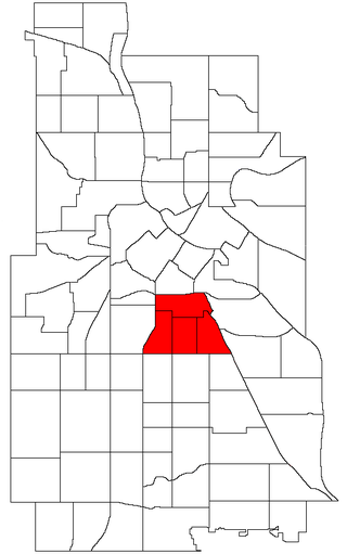
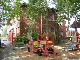
Phillips is a community in Minneapolis, just south of downtown. Phillips is a diverse area in many ways: its population includes people of many nationalities; it has a mix of residential, commercial and industrial uses; and it is home to several large employers such as Abbott Northwestern Hospital, Wells Fargo Mortgage and Allina Health Care Services along with small neighborhood businesses. Traditionally, it was both a community and a neighborhood. On May 9, 2002, Phillips neighborhood was subdivided into four smaller neighborhoods. The official neighborhoods are now known as Ventura Village, Phillips West, East Phillips, and Midtown Phillips. Though not an officially designated neighborhood, Phillips also includes the Little Earth residential area. The boundaries of the Phillips community are Interstate 94 to the north, Hiawatha Avenue to the east, Lake Street to the south, and Interstate 35W to the west.
College Hill is a neighborhood within the city limits of Tampa, Florida, in the United States. As of the 2010 census the neighborhood had a population of 703. However this includes only the subdivision of Belmont Heights Estates. Neighboring Ponce de Leon Estates is also part of this neighborhood the ZIP Codes serving the neighborhood are 33605 and 33610. The neighborhood is part of the East Tampa District. The neighborhood includes a new community of Belmont Heights Estates, which was built out in 2002 to replace substandard housing in the area.

Forest Park Southeast (FPSE) is a neighborhood of St. Louis, Missouri. It is bordered by Interstate 64 (U.S. Route 40) to the north, Vandeventer Avenue to the east, Interstate 44 to the south, and Kingshighway Boulevard and Forest Park to the west. Adjoining neighborhoods include Kings Oak and The Hill to the west, Southwest Garden to the south, Botanical Heights to the southeast, Midtown to the east, and the Central West End to the north.
Beaumont Park is a neighborhood in southwestern Lexington, Kentucky, United States. Its boundaries are Parkers Mill Road to the west, Lane Allen Road to the north, Lansill Dr to the east, and New Circle Road to the south.
Palomar Hills is a neighborhood in southwestern Lexington, Kentucky, United States. Its boundaries are Harrodsburg Road to the east, Man o' War Boulevard to the north, Bowman Mill Road to the south, and the Lexington urban growth boundary to the west.
Davis Bottom is a neighborhood just southwest of downtown Lexington, Kentucky, United States. Its boundaries are Broadway to the south, CSX railroad tracks to the west, High Street to the north, and Maxwell Street to the east. The area is also referred to as Davistown.
Beaumont Centre is a neighborhood and major retail and office park in southwestern Lexington, Kentucky, United States. Its boundaries are New Circle Road to the north, the older Harrods Hill neighborhood to the south, Man o' War Boulevard to the west, and Harrodsburg Road to the east. The area was one of the last undeveloped areas off New Circle Road, development began in the early 1990s.
Copperfield is a neighborhood in southwestern Lexington, Kentucky, United States. Its boundaries are the Jessamine County line to the south, Clays Mill Road to the east, Twain Ridge Road to the north, and Calevares Drive to the west.
Colony is a neighborhood in southwestern Lexington, Kentucky, United States. Its boundaries are Parkers Mill Road to the south and east, Versailles Road to the north, and New Circle Road to the west.
Claymont is a neighborhood in southwestern Lexington, Kentucky, United States. Its boundaries are Hill N Dale Road to the north, Clays Mill Road to the west, Pasadena Drive to the south, and Southview Drive to the east.
References
- 1 2 Harrods Hill Neighborhood Profile Retrieved 2013-08-09.
- ↑ Harrods Hill Neighborhood Association Retrieved on 2013-08-09


| | This Fayette County, Kentucky state location article is a stub. You can help Wikipedia by expanding it. |