Related Research Articles

Franklin County is a county located in the U.S. state of Kentucky. As of the 2020 census, the population was 51,541, making it the 2nd least populous capital county in the United States after Hughes County, South Dakota. Its county seat is Frankfort, the state capital. The county was formed in 1795 from parts of Woodford, Mercer and Shelby counties, and was named after the American inventor and statesman Benjamin Franklin. Franklin County is part of the Frankfort, Kentucky Micropolitan Statistical Area. It shares a name with Franklin County in Ohio, where Columbus is located. This makes it one of two pairs of capital cities in counties of the same name, along with Marion Counties in Oregon and Indiana.
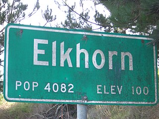
Elkhorn is an unincorporated community and census-designated place (CDP) in Monterey County, California, United States.

Moss Landing, formerly Moss, is an unincorporated community and census-designated place (CDP) in Monterey County, California, United States. It is located 18 miles (29 km) north-northeast of Monterey, at an elevation of 10 feet (3.048 m). It is on the shore of Monterey Bay, at the mouth of Elkhorn Slough and at the head of the submarine Monterey Canyon.

Prunedale is a census-designated place in Monterey County, California, United States. It is located 8 miles (13 km) north of Salinas at an elevation of 92 feet (28 m). The population was 18,885 as of the 2020 census, up from 17,560 in 2010. Plum trees were grown in Prunedale in the early days of its founding, but the trees died soon after due to poor irrigation and fertilizer.
Elkhorn City is a home rule-class city in Pike County, Kentucky, in the United States. The population was 982 at the 2010 census. The city is located in proximity to the Breaks Interstate Park.
Midway Township is a township in Saint Louis County, Minnesota, United States. The population was 1,399 at the 2010 census.

Beemer is a village in Cuming County, Nebraska, United States. The population was 678 at the 2010 census.
Wisner is a city in northwestern Cuming County, Nebraska, United States. The population was 1,170 at the 2010 census.

Elkhorn is a neighborhood and former city on the western edge of the city of Omaha, Nebraska, United States. The population was 6,062 at the 2000 census and was estimated by the Census Bureau at 8,192 in 2005. It was named after the Elkhorn River. Elkhorn was once an independent city in Douglas County until it was annexed by Omaha in 2007.

Norfolk is a city in Madison County, Nebraska, United States, 113 miles northwest of Omaha and 83 miles west of Sioux City at the intersection of U.S. Routes 81 and 275. The population was 24,210 at the 2010 census, making it the ninth-most populous city in Nebraska. It is the principal city of the Norfolk Micropolitan Statistical Area.

Elkhorn is a city in Walworth County, Wisconsin, United States. It is located 40 miles (64 km) southwest of Milwaukee. As of the 2020 census, it was home to 10,247 people, up from 10,084 at the 2010 census. It is the county seat.

Elkhorn is a census-designated place (CDP) in Jefferson County, Montana, United States, in the Elkhorn Mountains of the southwestern part of the state. As of the 2010 census it had a population of 10. The community is considered a ghost town, and two of its buildings are preserved as Elkhorn State Park.
The neighborhoods of Omaha are a diverse collection of community areas and specific enclaves. They are spread throughout the Omaha metro area, and are all on the Nebraska side of the Missouri River.
Highland Parks is a neighborhood in northwest Lexington, Kentucky, United States. It is a new subdivision started in the mid-2000s, located between the older Highlands and Oakwood neighborhoods. It is located south of Birch Drive and north of Boxwood Drive. It is bounded by Georgetown Road to the west and Oakwood Park to the east.
Cardinal Valley is a neighborhood in northwestern Lexington, Kentucky, United States. Its boundaries are Versailles Road to the south, Norfolk Southern railroad tracks to the north, Forbes Road to the east, and Cambridge Drive/Oxford Circle to the west.
Dogwood Trace is a neighborhood in southwestern Lexington, Kentucky, United States. Its boundaries are South Elkhorn Creek to the north and east, Harrodsburg Road to the west, and the Jessamine County line to the south.
Spindletop is a rural neighborhood north of Lexington, Kentucky, United States. Its boundaries are I-75 to the west and Berea Road to the south and east. It is located just south of the Kentucky Horse Park. It is named for Spindletop hall, a historic mansion once owned by Miles Franklin Yount, which is located within the neighborhood.
Cross Keys is a neighborhood in southwestern Lexington, Kentucky, United States. Its boundaries are Traveler Road to the east, Versailles Road to the north, Parks Mill Road to the north, and Lane Allen Road to the south.

Masterson Station is a neighborhood in northwestern Lexington, Kentucky, United States. Its boundaries are Masterson Station Park on the west, Leestown Road to the south, Greendale Road to the east, and Spurr Road to the north.
Highlands is a neighborhood in northwestern Lexington, Kentucky, United States. Its boundaries are Georgetown Road to the west, Oakwood Park to the east, and Citation Boulevard to the east. There are plans to develop a vacant field north of Highlands, it is unclear whether it will become part of Highlands or be a separate neighborhood.
References
- 1 2 Elkhorn Park Neighborhood Profile city-data.com. Retrieved on 2011-01-01


| | This Fayette County, Kentucky state location article is a stub. You can help Wikipedia by expanding it. |