Related Research Articles
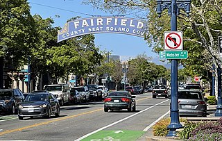
Fairfield is a city in and the county seat of Solano County, California, United States, in the North Bay sub-region of the San Francisco Bay Area. It is generally considered the midpoint between the cities of San Francisco and Sacramento, approximately 40 miles (64 km) from the city center of each city, the same from the city center of Oakland.

Wythall is a village and civil parish in the Bromsgrove District, in the north-east corner of the county of Worcestershire, England. Wythall parish borders Solihull and Birmingham, and had a population of 12,269 in the UK census of 2021.

Rancho Park is a residential neighborhood in the Westside of the city of Los Angeles, California with mostly single family homes and tree lined streets. The community is nestled between West Los Angeles and Cheviot Hills. This enclave draws young professionals and families and is home to residents working in a variety of professional occupations. History proves the neighborhood was once a part of Westwood until Olympic Blvd. was placed dividing the area North and South. The Southern section, now known as Rancho Park, felt cut off from its North side lobbying for its own identity in the 1930s.

Headley is a village and civil parish in the East Hampshire district of Hampshire, England. It is 1.8 miles (2.9 km) east of Bordon on the B3002 road.

Headley is a village and civil parish in the North Downs in Surrey, England. The nearest settlements are, to the west, Mickleham and Leatherhead; to the north, Ashtead and Langley Vale; to the east, Walton-on-the-Hill; and to the south, Box Hill. It is just outside the M25 motorway encircling London.
The Alcibiades Stakes is an American Thoroughbred horse race run annually in early October at Keeneland Race Course in Lexington, Kentucky. A Grade I race, it is open to two-year-old fillies willing to race one and one-sixteenth miles on the dirt. Sponsored by Darley Racing since 2003, the Alcibiades Stakes was named for Hal Price Headley's great foundation mare Alcibiades.

Bristow is an unincorporated community of Prince William County in Northern Virginia about 30 miles (48 km) from Washington, D.C. In 2014, Bristow's postal area population was 29,346, a 287% increase since 2000; however, the Bristow community is formally included in the Linton Hall, Virginia census-designated place (CDP).
Lindford is a village and civil parish in the East Hampshire district of Hampshire, England. It is approximately 1 mile (1.6 km) northeast of Bordon, and west of Headley, East Hampshire on the B3004 road.

Chastain Memorial Park is the largest city park in Atlanta, Georgia. It is a 268-acre (1.08 km2) park near the northern edge of the city. Included in the park are jogging paths, playgrounds, tennis courts, a golf course, swimming pool, horse park and amphitheater.
Arford is a village in the East Hampshire district of Hampshire, England, just north of the B3002 road, and is part of the civil parish of Headley.
Headley Down is a village within the civil parish of Headley in the East Hampshire district of Hampshire, England, bounded on two sides by Ludshott Common, a National Trust heathland reserve. The village began with a few buildings in the 1870s and became a thriving community that in the 20th century outgrew the parish centre of Headley.
Standford is a village in the East Hampshire district of Hampshire, England. It is 1.3 miles (2.1 km) east of Bordon, on the B3004 road. It is in the civil parish of Headley.
Menow (1935–1964) was an American Thoroughbred racehorse. He won several important races in 1937, when he was voted American Champion Two-Year-Old Male Horse.
Fairway is a neighborhood in southeast Lexington, Kentucky, United States. Its boundaries are Sherman Avenue to the north, railroad tracks to the north, Richmond Road to the west, and the Idle Hour Golf Course to the south.

Deerwood was the first gated community in Florida, US. After it was established in the mid-1960s, it was the most exclusive residential area on Jacksonville's Southside. The golf course hosted the Greater Jacksonville Open in the late 1960s and early 1970s, forerunner of The Players Championship, and was once the site of talks between President Gerald Ford and Egyptian President Anwar Sadat in November 1975.
Burley Park is a neighborhood in southwestern Lexington, Kentucky, United States. It is named for the large number of tobacco warehouses that were once located in the neighborhood. Its boundaries are Waller Avenue and Mason Headley Road to the south, east of Beacon Hill Drive/ Summerville Drive/ Addison Park to the west, Red Mile Road and Virginia Avenue to the north, and RJ Corman railroad tracks to the east. The smaller Golf View Estates neighborhood is typically included in Burley Park.
Golf View Estates is a neighborhood in southwestern Lexington, Kentucky, United States. Its name is derived from its location next to the Campbell House golf course. Its boundaries are the Campbell House and its golf course to the south, Addison Park to the west, Red Mile Road to the north, and South Broadway to the east.
Pine Meadow is a neighborhood in southwestern Lexington, Kentucky, United States. Its boundaries are Mason Headley Road to the west, Pine Meadow Park to the north, Addison Park to the east, and the Campbell House golfcourse to the south.
Mason Headley is a neighborhood in southwestern Lexington, Kentucky, United States. Its boundaries are Mason Headley Road to the north, Laurel Hill Road to the south, Beacon Hill Drive to the west, and Cold Harbor Drive to the east.
Briggsdale is a neighborhood of Franklin County in the city of Columbus, Ohio. The neighborhood is on the west/southwest side of the city within the Hilltop area. The area was first settled and founded by the family of Joseph M. Briggs, after whom the neighborhood was named. Joseph Briggs was an active figure in the early years of the township and county operations. The Briggsdale Methodist church was founded with his help, and it now exists as the New Horizons Methodist Church. The present-day Briggsdale neighborhood is located near the historical Green Lawn Cemetery to the north as well as Briggs High School to the west.
References
- 1 2 Headley Green Neighborhood Profile Retrieved 2014-07-11.


| | This Fayette County, Kentucky state location article is a stub. You can help Wikipedia by expanding it. |