Paris Pike is the local name for the 14 mile (23km) stretch of U.S. Routes 27/68 between Paris and Lexington, Kentucky.
For years, this stretch of road had only two side-by-side lanes and no emergency breakdown lane. Given the large amount of auto and farm machinery traffic the road carried, plus the high number of fatalities from vehicular accidents, the Commonwealth of Kentucky Department of Transportation opted to add two more lanes.
In 1966, discussions were held about how best to widen the road. The original project razed historical structures and would mandate a four-lane divided highway with a 40-foot (12m) uniform grassy median. Local citizens took the Transportation Cabinet to court to stop the plans.
In 1977, the Bluegrass Land and Nature Trust stepped in to help oppose the plans.
In 1979, an injunction was issued and the existing plans for widening were scrapped. The court issued a statement in that it wanted more considerate and careful alternatives that would preserve the highway's historic significance. In 1980, the Paris Pike widening project was cancelled. An injunction was issued.
In 1986, proponents and opponents of the Paris Pike widening project met, agreeing to work together in order to improve the safety and capacity of the deadly road. Fatalities up to that point were increasing every year, claiming, for instance, a family of five in 1985.
In 1990, Bluegrass Tomorrow created a committee of supporters and opponents of the Paris Pike project with hope that a compromise could be reached on how the roadway should be improved. Unfortunately, later that year the Kentucky Department of Transportation released their Record of Decision, in that the Paris Pike should be improved by widening the highway to four-lanes with a 40-foot (12m) median, almost exactly like the plans in 1966 which were later cancelled.
Later in 1991, the U.S. District Court turned down a request by federal and state officials to lift portions of a 1979 injunction and denied the state transportation cabinet from selecting a design task force. During this time, a proposal by then governor Brereton Jones was derailed as it would have utilized an abandoned railroad corridor to the east of the existing Paris Pike.
In 1992, the Paris Pike Committee was formed with representatives from Fayette and Bourbon counties and two preservation organizations. This new committee would later set specific guidelines regarding roadway design, land use, and preservation, stating that the new highway could be more beautiful than what currently existed. Later meetings extended those statements with a pact to preserve the land around the highway from development forever.
Several of those design specifications called for a four-lane highway with grass shoulders, and where possible, the existing roadway would be used. The highway would flow with the contours of the landscape, and the existing rock walls and entryways would be preserved. Other features that were mentioned included guardrail considerations and landscaping. The final report from the Paris Pike Committee was signed off on in May 1993 and endorsed by all preservation and conservation groups who at one point were at odds over this widening project.
The injunction was lifted in September 1993. Landscape architectGrant Jones and his Seattle-based firm, working with engineering consultant H. W. Lochner, Inc. of Lexington, designed the new Paris Pike utilizing the criteria set forth by the Paris Pike Committee.[1][2]
The widening project began in 1997 and the four-lane divided highway was completed in 2003. The total budget for the project was $69.9 million, however, it was completed at a cost of $93 million or $4.5 million per mile, 1.8 times the cost of a typical four-lane highway in the state.
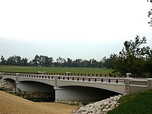
As a result of the widening project, the level-of-service along the highway went from an overall grade of 'F' (failing) to 'A' (excellent) and became one of the most scenic byways in the nation. The desire by the designers of the highway, the general public, and the numerous preservation organizations to maintain the historic character of the corridor and to maintain its unique character made the cost extraordinarily high but it was well worth the cost. Dry-laid limestone rock fences were dismantled and reconstructed by hand, for instance, and extensive landscaping and tree planting using native species were utilized. As a result of this careful construction, the Paris Pike project won a 2002 Merit-Design award from the American Society of Landscape Architects[1] as well as the 2003 Federal Highway Administration's Environmental Excellence Award and the National Partnership for Highway Quality 2003 State Award.
The Historic Columbia River Highway is an approximately 75-mile-long (121 km) scenic highway in the U.S. state of Oregon between Troutdale and The Dalles, built through the Columbia River Gorge between 1913 and 1922. As the first planned scenic roadway in the United States, it has been recognized in numerous ways, including being listed on the National Register of Historic Places, being designated as a National Historic Landmark by the U.S. Secretary of the Interior, being designated as a National Historic Civil Engineering Landmark by the American Society of Civil Engineers, and being considered a "destination unto itself" as an All-American Road by the U.S. Secretary of Transportation. The historic roadway was bypassed by the present Columbia River Highway No. 2 from the 1930s to the 1950s, leaving behind the old two-lane road. The road is now mostly owned and maintained by the state through the Oregon Department of Transportation as the Historic Columbia River Highway No. 100 or the Oregon Parks and Recreation Department as the Historic Columbia River Highway State Trail.
U.S. Route 68 is a United States highway that runs for 560 miles (900 km) from northwest Ohio to Western Kentucky. The highway's western terminus is at US 62 in Reidland, Kentucky. Its present northern terminus is at Interstate 75 in Findlay, Ohio, though the route once extended as far north as Toledo. US 68 intersects with US 62 three times during its route.
Kentucky Route 9 (KY 9) is a 116.285-mile-long (187.143 km) state highway maintained by the Kentucky Transportation Cabinet in the U.S. Commonwealth of Kentucky. The highway extends from Grayson to Newport, roughly paralleling the Ohio River between Vanceburg and Newport.
Kentucky Route 80 (KY 80) is a 483.55-mile-long (778.20 km) state highway in the southern part of the U.S. state of Kentucky. The route originates on the state's western border at Columbus in Hickman County, and stretches across the southern portion of the state, terminating southeast of Elkhorn City on the Virginia state line. It is the longest Kentucky State Highway, though the official distance as listed in route logs is much less due to multiple concurrencies with U.S. Route 68 (US 68) and U.S. Route 23.
State Route 4, formerly known as Inter-county Highway 4 until 1921 and State Highway 4 in 1922, is a major north–south state highway in Ohio. It is the fifth longest state route in Ohio. Its southern terminus is at U.S. Route 42 in Cincinnati, Ohio, and its northern terminus is at U.S. Route 6 in Sandusky, Ohio. Its path is nearly ruler-straight for many miles. Some portions of the route are still marked as Dixie Highway. The northern portion was constructed by the Columbus and Sandusky Turnpike Company, see Turnpike Lands.
New Circle Road, also known as Kentucky Route 4, is a Kentucky state highway that serves as an inner beltway around Lexington, which is part of the consolidated city-county government with Fayette County.
The Cumberland Gap Tunnel is a dual-bore, four lane vehicular tunnel that carries U.S. Route 25E under Cumberland Gap National Historical Park near the intersection of Kentucky, Tennessee, and Virginia. The tunnel consists of two separate bores which carry four lanes of traffic between Cumberland Gap, Tennessee and Middlesboro, Kentucky. It is one of only two mountain vehicular tunnels in the United States that cross a state line, the other being the East River Mountain Tunnel on Interstate 77 and U.S. Route 52 between Virginia and West Virginia. The tunnel opened to traffic in 1996 and replaced a section of highway through the Cumberland Gap that had earned the nickname "Massacre Mountain" due to its hazardous design and high rate of traffic accidents.
The Ohio River Bridges Project was a transportation project in the Louisville metropolitan area involving the reconstruction of the Kennedy Interchange, the completion of two new Ohio River bridges, and the reconstruction of ramps on Interstate 65 between Muhammad Ali Boulevard and downtown Louisville.
The Ohio Department of Transportation is the administrative department of the Ohio state government responsible for developing and maintaining all state and U.S. roadways outside of municipalities and all Interstates except the Ohio Turnpike. In addition to highways, the department also helps develop public transportation and public aviation programs. ODOT is headquartered in Columbus, Ohio. Formerly, under the direction of Michael Massa, ODOT initiated a series of interstate-based Travel Information Centers, which were later transferred to local sectors. The Director of Transportation is part of the Governor's Cabinet.
Man o' War Boulevard, named after the racehorse Man o' War, is an almost 17-mile (27 km) urban arterial, circling Lexington, Kentucky to its south. Its western terminus is at US 60 / Keeneland Boulevard at Keeneland Race Course's main entrance, from which the highway heads southeast, intersecting with US 68, US 27, and other roads. It then turns east and northeast, intersecting KY 1974, US 25/US 421, and I-75, before ending at US 60 at Brighton. The majority of the road is a four-lane divided highway with curbs and sidewalks maintained by the Lexington-Fayette Urban County Government, but the 1.429-mile (2.300 km) portion east of I-75 is maintained by the Kentucky Transportation Cabinet as Supplemental Road Kentucky Route 1425, and only carries two lanes.
Citation Boulevard, a four-lane divided highway, currently extends from just west of US 25 at the Norfolk Southern Railway to KY 922 in Lexington, Kentucky. Known as Phase I, it was completed in 2001 and included a bridge over Cane Run. Phase II extends southwest from the Norfolk Southern Railway to US 421 at Alexandria Drive and includes a span over the railroad. The highway west of Newtown Pike was constructed by the Kentucky Transportation Cabinet.
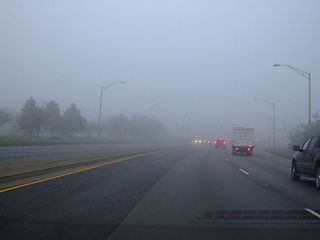
Interstate 64 (I-64) in the US state of Virginia runs east–west through the middle of the state from West Virginia to the Hampton Roads region, for a total of 299 miles (481 km). It is notable for crossing the mouth of the harbor of Hampton Roads on the Hampton Roads Bridge–Tunnel (HRBT), the first bridge–tunnel to incorporate artificial islands, concurrent with U.S. Route 60 (US 60). Also noteworthy is a section through Rockfish Gap, a wind gap in the Blue Ridge Mountains, which was equipped with an innovative system of airport-style runway lighting embedded into the pavement to aid motorists during periods of poor visibility due to fog or other conditions.
Grant Richard Jones is an American landscape architect, poet, and founding principal of the Seattle firm Jones & Jones Architects, Landscape Architects and Planners. In more than four decades of practice, his work in ecological design has garnered widespread recognition for its broad-based and singular approach, one that is centered on giving voice to the land and its communities. Called the “poet laureate of landscape architecture” Jones's poetry informs his designs.
Interstate 20 (I-20) is the main east–west Interstate in the state of South Carolina, linking the state with important transportation and business hubs to the north, west, and south, including Atlanta, Georgia; Charlotte, North Carolina ; Savannah, Georgia ; and Washington, D.C..
Delaware Route 299 (DE 299) is a 9.77-mile-long (15.72 km) state highway in New Castle County, Delaware. It runs from Maryland Route 282 (MD 282) at the Maryland state line east of Warwick, Maryland to DE 9 in Mathews Corners, traveling through Middletown and Odessa. The route intersects the U.S. Route 301 (US 301) toll road, DE 15, and DE 71 in Middletown, the DE 1 toll road east of Middletown, and US 13 in Odessa. The highway travels through a mix of suburban development and some farmland.
Kentucky Route 15 begins at a junction of US 119/Corridor F & Business KY 15 in Whitesburg, and terminates in Winchester at US 60. It is a major route, connecting the coalfields of the Cumberland Plateau with Lexington and other cities in the Bluegrass region. The segment from Whitesburg to KY 15 at Campton, which in turn connects to the Bert T. Combs Mountain Parkway near the town, is also the primary part of Corridor I of the Appalachian Development Highway System.
Delaware Route 52 (DE 52) is a state highway in New Castle County, Delaware. The route runs from U.S. Route 13 Business in downtown Wilmington north to Pennsylvania Route 52 (PA 52) at the Pennsylvania border near Centerville. DE 52 runs through the city of Wilmington and passes through areas of the Brandywine Valley north of Wilmington. DE 52 intersects Interstate 95 (I-95)/US 202 and DE 2 in Wilmington and DE 100/DE 141 and DE 82 in Greenville. The entire route is designated as part of the Brandywine Valley National Scenic Byway, a National Scenic Byway and Delaware Byway, while most of the route is also designated as part of the Harriet Tubman Underground Railroad Byway of the Delaware Byways system. The road was built as the Kennett Pike, a turnpike, between 1811 and 1813. The Kennett Pike was bought by Pierre S. du Pont in 1919 and was widened and paved before being sold to the State of Delaware for $1. The road received the DE 52 designation by 1936.
Interstate 75 (I-75) runs from near Williamsburg to Covington by way of Lexington in the US state of Kentucky. I-75 enters the Cumberland Plateau region from Tennessee, then descends into the Bluegrass region through the Pottsville Escarpment before crossing the Ohio River into Ohio. I-75 follows along the U.S. Route 25 (US 25) corridor for the entire length of Kentucky.
The Woodlands Trace National Scenic Byway, also known as "The Trace," is the major north–south roadway that traverses the Land Between the Lakes National Recreation Area in two counties in western Kentucky and northwestern Stewart County in northwest Middle Tennessee. It is estimated to be 43.1 miles (69.4 km) in length. The road is part of the National Scenic Byway system. Although it is not signed, it is listed on LBL's road logs as FD-100.
This page is based on this Wikipedia article Text is available under the CC BY-SA 4.0 license; additional terms may apply. Images, videos and audio are available under their respective licenses.