
Karst is a topography formed from the dissolution of soluble carbonate rocks such as limestone and dolomite. It is characterized by features like poljes above and drainage systems with sinkholes and caves underground. There is some evidence that karst may occur in more weathering-resistant rocks such as quartzite given the right conditions.

A sinkhole is a depression or hole in the ground caused by some form of collapse of the surface layer. The term is sometimes used to refer to doline, enclosed depressions that are also known as shakeholes, and to openings where surface water enters into underground passages known as ponor, swallow hole or swallet. A cenote is a type of sinkhole that exposes groundwater underneath. Sink and stream sink are more general terms for sites that drain surface water, possibly by infiltration into sediment or crumbled rock.
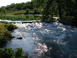
Mammoth Spring is a large, first magnitude karst spring that arises in the Ozark Plateau within the state of Arkansas. It is the largest spring in Arkansas and the third-largest spring within the Ozark Plateau region behind Big Spring and Greer Spring. Mammoth Spring is the seventh-largest natural spring in the world.
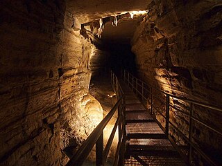
Forestville Mystery Cave State Park is a state park in Minnesota. It contains the village of Forestville, which has been restored to a 19th-century appearance. The Minnesota Historical Society operates it as a historic site. Below ground the park contains Mystery Cave, the state's longest cave, which is open to the public. The park is between Spring Valley and Preston, Minnesota.
The Woodville Karst Plain Project or WKPP, is a project and organization that maps the underwater cave systems underlying the Woodville Karst Plain. This plain is a 450-square-mile (1,200 km2) area that runs from Tallahassee, Florida, U.S. to the Gulf of Mexico and includes numerous first magnitude springs, including Wakulla Springs, and the Leon Sinks Cave System, the longest underwater cave in the United States. The project grew out of a cave diving research and exploration group established in 1985 and incorporated in 1990.

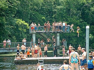
Wes Skiles Peacock Springs State Park is a 733-acre (297 ha) Florida State Park located on Peacock Springs Road, two miles (3 km) east of Luraville and on State Road 51, 16 miles (26 km) southwest of Live Oak, Florida. Activities include picnicking, swimming and diving, and wildlife viewing. Among the wildlife of the park are deer, bobcats, raccoon, squirrels, beaver and otters, as well as turkey, blue heron and barred owls. The park name commemorates the work of diver and explorer Wes Skiles. Prior to 2010 the park was known as Peacock Springs State Park. Amenities include a nature trail, six sinkholes, and Peacock and Bonnet Springs, with miles of underwater caves popular with cave divers. The two springs are tributaries of the Suwannee River. The park is open from 8:00 am till sundown year round.

Wakulla Springs is located 14 miles (23 km) south of Tallahassee, Florida and 5 miles (8.0 km) east of Crawfordville in Wakulla County, Florida at the crossroads of State Road 61 and State Road 267. It is protected in the Edward Ball Wakulla Springs State Park.

The Marble Arch Caves are a series of natural limestone caves located near the village of Florencecourt in County Fermanagh, Northern Ireland. The caves are named after the nearby Marble Arch, a natural limestone arch at the upstream end of Cladagh Glen under which the Cladagh River flows. The caves are formed from three rivers draining off the northern slopes of Cuilcagh mountain, which combine underground to form the Cladagh. On the surface, the river emerges from the largest karst resurgence in Ireland, and one of the largest in the United Kingdom. At 11.5 kilometres (7.1 mi) the Marble Arch Caves form the longest known cave system in Northern Ireland, and the karst is considered to be among the finest in the British Isles.
A losing stream, disappearing stream, influent stream or sinking river is a stream or river that loses water as it flows downstream. The water infiltrates into the ground recharging the local groundwater, because the water table is below the bottom of the stream channel. This is the opposite of a more common gaining stream which increases in water volume farther downstream as it gains water from the local aquifer.

The Big Bend of Florida, United States, is an informally named geographic region of North Florida where the Florida Panhandle transitions to the Florida Peninsula south and east of Tallahassee. The region is known for its vast woodlands and marshlands and its low population density relative to much of the state. The area is home to the largest single spring in the United States, the Alapaha Rise, and the longest surveyed underwater cave in the United States, the 32-mile (51 km) Wakulla-Leon Sinks cave system.

The Santa Fe River is a 75-mile (121 km) river in northern Florida. The watershed of the river is approximately 1,380 square miles (3,574 km2) and spreads across southern Columbia, southern Suwannee, western Bradford, far southern Baker, Union, northern and eastern Gilchrist, and northern Alachua counties. The headwaters of the river are Lake Santa Fe, near Keystone Heights. The Santa Fe River is usually a slow-flowing river. This slow speed, combined with the abundant leaf-drop from nearby trees, especially Bald Cypress, leads to a very dark-brown river due to dissolved tannins.

The Lost River is a river that rises in Vernon Township, Washington County, Indiana, and discharges into the East Fork of the White River in Lost River Township, Martin County, Indiana. The river's unusual hydrology has led to two of its features being named as National Natural Landmarks.
Karst Underwater Research (KUR) is a registered 501(c)(3) non-profit organization that specializes in the research and documentation of karst aquifers and their corresponding surface features. KUR members perform a variety of scientific processes, including mapping and cartography, radio location, photography, videography, YSI water analysis and sampling.
A ponor is a natural opening where surface water enters into underground passages; they may be found in karst landscapes where the geology and the geomorphology is typically dominated by porous limestone rock. Ponors can drain stream or lake water continuously or can at times work as springs, similar to estavelles. Morphologically, ponors come in forms of large pits and caves, large fissures and caverns, networks of smaller cracks, and sedimentary, alluvial drains.

The Greenbrier River Watershed Association (GRWA) is one of the oldest watershed associations in the state of West Virginia, founded in 1990. It has supported the creation of other watershed associations throughout the state and maintains a policy of "upstream courtesy" and "downstream courtesy" with its neighbors.

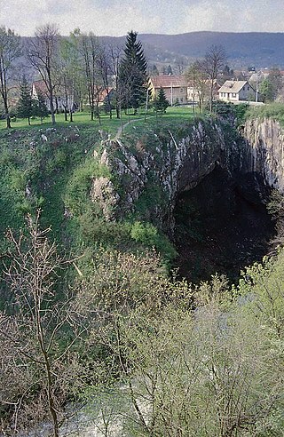
Škocjan Caves is a cave system located in Slovenia. Škocjan Caves was included on UNESCO’s list of natural and cultural World Heritage Sites in 1986. Škocjan Caves is a significant underground phenomenon on the Karst Plateau and in Slovenia. After gaining independence from Yugoslavia in 1991, Slovenia made a commitment to actively protect the Škocjan Caves area. To fulfill this commitment, Škocjan Caves Regional Park was established, along with its managing authority, the Škocjan Caves Park Public Service Agency.
Škocjan Caves Regional Park is located in the Škocjan Karst, a vast flat landscape that lies at an elevation between 420 and 450 m in the southeast part of the Karst area. Following its independence, Slovenia committed itself to protecting the Škocjan Caves area; for this reason, it established Škocjan Caves Regional Park and its managing authority, the Škocjan Caves Park Public Service Agency.
Edward Ball Wakulla Springs State Park is a Florida State Park in Wakulla County, Florida, United States. This 6,000 acre (24 km2) wildlife sanctuary, located south of Tallahassee, is listed on the National Register of Historic Places, and designated a National Natural Landmark.
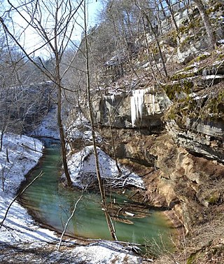
Cedar Sink is a vertical-walled large depression, or sinkhole, in the ground, that is located in Edmonson County, Kentucky and contained within and managed by Mammoth Cave National Park. The sinkhole measures 300 feet (91.4 m) from the top sandstone plateau to the bottom of the sink and was caused by collapse of the surface soil. The landscape is karst topography, which means the region is influenced by the dissolution of soluble rocks. Sinkholes, caves, and dolines typically characterize these underground drainage systems. Cedar Sink has a bottom area of about 7 acres (2.8 ha) and has more fertile soil compared to the ridgetops.


