External links


| | This Fayette County, Kentucky state location article is a stub. You can help Wikipedia by expanding it. |
Burley Park | |
|---|---|
| Coordinates: 38°02′05″N84°31′04″W / 38.0346°N 84.5179°W | |
| Country | United States |
| State | Kentucky |
| County | Fayette |
| City | Lexington |
| Time zone | UTC-5 (Eastern (EST)) |
| • Summer (DST) | UTC-4 (EDT) |
| ZIP code | 40504 |
| Area code | 859 |
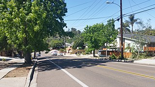
Burley Park is a neighborhood in southwestern Lexington, Kentucky, United States. It is named for the large number of tobacco warehouses that were once located in the neighborhood. Its boundaries are Waller Avenue and Mason Headley Road to the south, east of Beacon Hill Drive/ Summerville Drive/ Addison Park to the west, Red Mile Road and Virginia Avenue to the north, and RJ Corman railroad tracks to the east. The smaller Golf View Estates neighborhood is typically included in Burley Park.
| | This Fayette County, Kentucky state location article is a stub. You can help Wikipedia by expanding it. |

Lakeview, also spelled Lake View, is one of the 77 community areas of Chicago, Illinois. Lakeview is located in the city's North Side. It is bordered by West Diversey Parkway on the south, West Irving Park Road on the north, North Ravenswood Avenue on the west, and the shore of Lake Michigan on the east. The Uptown community area is to Lakeview's north, Lincoln Square to its northwest, North Center to its west, and Lincoln Park to its south. The 2020 population of Lakeview was 103,050 residents, making it the second-largest Chicago community area by population.
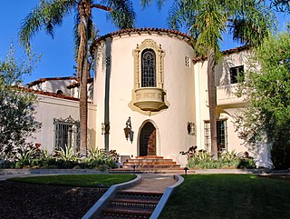
Los Feliz is a hillside neighborhood in the greater Hollywood area of Los Angeles, California, abutting Hollywood and encompassing part of the Santa Monica Mountains. The neighborhood is named after the Feliz family of Californios who had owned the area since 1795, when José Vicente Feliz was granted Rancho Los Feliz.

Lawrence Park is a neighbourhood in Toronto, Ontario, Canada. It is bordered by Yonge Street to the west and Bayview Avenue to the east, and from Blythwood Ravine on the south to Lawrence Avenue on the north. Lawrence Park was one of Toronto's first planned garden suburbs. Begun in the early part of the 20th century, it did not fully develop until after the Second World War. It was ranked the wealthiest neighbourhood in all of Canada in 2011.

Baldwin Hills is a neighborhood within the South Los Angeles region of Los Angeles, California. It is often referred to as the Black Beverly Hills.

Crocker-Amazon is a neighborhood in San Francisco that borders the Excelsior District. Crocker-Amazon covers the area south of Mission Street and Geneva Avenue, extending toward suburban Daly City. The neighborhood is adjacent to Crocker-Amazon Park, named after the Charles Crocker land holdings that once made up the area, and Amazon Avenue in the Excelsior. The winding streets of the neighborhood straddle the border between San Francisco and Daly City and largely blend in with the adjacent Daly City neighborhoods of Crocker and Southern Hills.

Lake Avenue is a major north–south feeder road for the Pasadena and Altadena communities in Los Angeles County, California. The road was developed in the mid 19th century and takes its name from a lake which was located at its southernmost end known variously as Mission Lake, Kewen Lake, and Wilson Lake reflecting different owners of the land. The lake bed still exists as a municipal park in the City of San Marino just south of the Raymond Dike, but it holds no water. It has been surrounded by residences who are served by a crisscross set of roads that dip into the edges of impression and back out the other side. Lake Avenue is approximately 5.06 miles (8.14 km) in length.
The College Area is a residential community in the Mid-City region of San Diego, California, United States. The College Area is dominated by San Diego State University, after which the area is named. Several neighborhoods in the College Area were developed in the 1930s, with others becoming established in the post-war period. The College Area is bordered on the west by Kensington and Talmadge and on the east by the city of La Mesa. El Cajon Boulevard is a busy shopping district; additional retail, entertainment and dining establishments are located in a new housing and commercial complex known as South Campus Plaza on College Avenue at Aztec Center. The College Area includes the neighborhoods of the Catoctin Area, Dennstedt Point, East Falls View Drive, Saranac-Mohawk, and an Orthodox Jewish neighborhood in the area near Congregation Beth Jacob Orthodox Synagogue on College Avenue. The region includes Alvarado Hospital, a 306-bed acute care facility, and the College-Rolando branch of the San Diego Public Library.

The Greater Grand Forks Greenway is a huge greenway bordering the Red River and Red Lake River in the twin cities of Grand Forks, North Dakota and East Grand Forks, Minnesota. At 2,200 acres (9 km2), the Greenway is more than twice the size of New York City's Central Park. It has an extensive, 20-mile (32 km) system of bike paths, which are used by bikers, walkers, joggers, and rollerbladers. In 2007, the system was designated as a National Recreation Trail by the National Park Service.
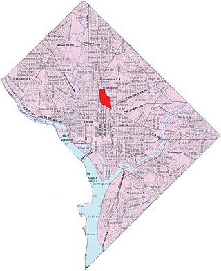
Pleasant Plains is a neighborhood in central Washington, D.C. largely occupied by Howard University. For this reason it is also sometimes referred to as Howard Town or, less frequently, Howard Village.

Humber Heights-Westmount, also known as Humbervale, is a neighbourhood in Toronto, Ontario, Canada. The neighbourhood is bounded by the west bank of the Humber River, west to Royal York Road and south to Eglinton Avenue West. The Humber Creek divides the area into the northern 'Humber Heights' and the southern 'Westmount' centred along Scarlett Road and La Rose Avenue.

University City (UC) is a community in San Diego, California, located in the northwestern portion of the city next to the University of California, San Diego. University City is bordered by La Jolla and Interstate 5 to the west, Miramar and Interstate 805 to the east, and North Clairemont and Highway 52 to the south, giving the community a triangular-shaped boundary. University City is a part of District 6, which is represented by Councilmember Kent Lee on the San Diego City Council.
Columbus, the state capital and Ohio's largest city, has numerous neighborhoods within its city limits. Neighborhood names and boundaries are not officially defined. They may vary or change from time to time due to demographic and economic variables.
East Lake is a neighborhood on the east side of Atlanta, Georgia, situated in DeKalb County. It is the easternmost of the 238 neighborhoods in the City of Atlanta. It is home to East Lake Golf Club, the site of PGA's annual Tour Championship. East Lake lies mostly within the 30317 zip code.
Cheviot Hills is a neighborhood on the Westside of the city of Los Angeles, California.
Elm Thicket is a primarily residential neighborhood in North Dallas, Texas near Love Field airport and the neighborhoods of Love Field, Bluffview, Greenway Parks, University Park and Highland Park.
Northeast Bakersfield is the northeast region of Bakersfield, California. It is roughly bounded by Panorama Drive and the Kern River to the north, Alfred Harrell Highway/Comanche Drive to the east, Edison Highway to the south, and Union Avenue to the west. The region of East Bakersfield is located within these boundaries but is usually not considered part of the Northeast. Instead, the Northeast wraps around the boundaries of East Bakersfield. Other boundaries are the city limits.

Emerald Hills is a neighborhood in the southeastern section of the city of San Diego, California, United States. It is bordered by Oak Park and California State Route 94 on the north, Chollas View and Euclid Avenue on the west, Encanto and Skyline Drive on the east, and Valencia Park and Market Street on the south. Major thoroughfares include Kelton Road and Roswell Street.

Ferry Point Park is a 413.8-acre (167.5 ha) park in the Bronx, New York City. The park site is a peninsula projecting into the East River roughly opposite the College Point and Malba neighborhoods of Queens. The park is located on the eastern shore of Westchester Creek, adjacent to the neighborhood of Throggs Neck. The park is operated by the New York City Department of Parks and Recreation. The Hutchinson River Expressway crosses the park to the Bronx-Whitestone Bridge, splitting it into east and west sides.

Comstock is a neighborhood in Spokane, Washington. It is located on the south side of the city in a broader area commonly known as the South Hill. The neighborhood is primarily single-family residential, and a mix of homes built during the streetcar era and then built during the post-World War II housing boom. The neighborhood is also home to a few commercial districts, including the regionally important Manito Shopping Center, two schools, the eponymous Comstock Park, sports fields and a golf course.