
Lake in the Hills is a village in McHenry County, Illinois, United States. As of the 2020 census, the population was 28,982.

Chillum is an unincorporated area and census-designated place in Prince George's County, Maryland, United States, bordering Washington, D.C., and Montgomery County.

Blaine is a suburban city in Anoka and Ramsey counties in Minnesota, United States. Once a rural town, Blaine's population has increased significantly in the last 60 years. For several years, Blaine led the Twin Cities metro region in new home construction. The population was 70,222 at the 2020 census. The city is mainly in Anoka County, and is part of the Minneapolis–Saint Paul metropolitan area.

Lexington is a suburban town in Middlesex County, Massachusetts, United States, located 10 miles (16 km) from Downtown Boston. The population was 34,454 as of the 2020 census. The area was originally inhabited by Native Americans, and was first settled by Europeans c. 1642 as a farming community. Lexington is well known as the site of the first shots of the American Revolutionary War, in the Battle of Lexington on April 19, 1775, where the "Shot heard 'round the world" took place. It is home to Minute Man National Historical Park.
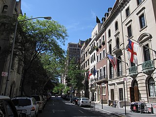
The Upper East Side, sometimes abbreviated UES, is a neighborhood in the borough of Manhattan in New York City, bounded approximately by 96th Street to the north, the East River to the east, 59th Street to the south, and Central Park and Fifth Avenue to the west. The area incorporates several smaller neighborhoods, including Lenox Hill, Carnegie Hill, and Yorkville. Once known as the Silk Stocking District, it has long been the most affluent neighborhood in New York City.

Oxon Hill is an unincorporated area and census-designated place (CDP) in southern Prince George's County, Maryland, United States. Oxon Hill is a close suburb of Washington, located southeast of the downtown district and east of Alexandria, Virginia. Since 2008, it contains the 300-acre (120 ha) National Harbor development on the shore of the Potomac River.

Corktown is a neighborhood located in Detroit, Michigan. It is the oldest extant neighborhood in the city. The current boundaries of the district include I-75 to the north, the John C. Lodge Freeway to the east, Bagley and Porter streets to the south, and Rosa Parks Boulevard to the west. The neighborhood was listed on the National Register of Historic Places in 1978.

Arrowhead Springs is a highly mountainous neighborhood in the 81-square-mile (210 km2) municipality of San Bernardino, California, officially annexed to the city on November 19, 2009. The neighborhood lies below the Arrowhead geological monument, which is California Historical Landmark #977.
Arden Heights is a name increasingly applied to the western part of Annadale, a neighborhood located on the South Shore of Staten Island, New York City, USA. The name "Arden Heights" is found on most maps of New York City, including Hagstrom's.
Mid-Wilshire is a neighborhood in the central region of Los Angeles, California. It is known for the Los Angeles County Museum of Art, the Petersen Automotive Museum, and the Miracle Mile shopping district.

Brambleton is a census-designated place (CDP) in Loudoun County, Virginia, United States, south of the Dulles Greenway. The population as of the 2010 United States Census was 9,845. In 2017, Brambleton had an estimated population of 19,900, with a median age of 34.3 and a median household income of $173,690. Between 2016 and 2017 the population of Brambleton, VA grew from 17,063 to 19,876, a 16.5% increase and its median household income grew from $164,321 to $173,690, a 5.7% increase. Construction started on the Brambleton community in 2001.

Mission Hill is a 3⁄4 square mile, primarily residential neighborhood of Boston, bordered by Roxbury, Jamaica Plain and Fenway-Kenmore and the town of Brookline. The neighborhood has two main streets, namely Tremont Street and Huntington Avenue. It is served by several stations on the MBTA's Green Line E branch, as well as Roxbury Crossing station on the Orange Line.
University Hills is a housing development on the campus of the University of California, Irvine (UCI) in southern Irvine, California, United States, consisting of 1226 for-sale homes and 384 rental units. University Hills was developed by the Irvine Campus Housing Authority, a not-for-profit corporation under the control of the university. UC Irvine developed the area as "a way to compensate for high Orange County housing costs that can keep a recruit from accepting a job at the university."

Walnut Bend is a subdivision in Houston, Texas, United States.

Packer Park is a neighborhood in the South Philadelphia section of Philadelphia, Pennsylvania, United States that originally included 1,000 homes built in two unique builder developments, of Packer Park in the 1950s and Brinton Estates during the 1990s. It is now one of four residential communities to be designated as Packer Park. The original footprint community is also one of four adjacent communities that form Philadelphia's Sports Complex Special Services District. The approximate boundaries are Packer Avenue to the north, Hartranft Street to the south including FDR Park farther south, Broad Street to the east known as the Southern Parkway, and I-76 to the far west. Packer Park has been considered home to one of the most organized community groups in the South Philadelphia region.

Louisville, Kentucky is home to numerous structures that are noteworthy due to their architectural characteristics or historic associations, the most noteworthy being the Old Louisville neighborhood, the third largest historic preservation district in the United States. The city also boasts the postmodern Humana Building and an expanding Waterfront Park which has served to remove the former industrial appearance of the riverfront.

Cherry Hill is a census-designated place (CDP) in Prince William County, Virginia, United States. The population was 16,000 according to the 2010 Census. As of the 2020 census, it was estimated to be 23,683. The CDP is made up of the Cherry Hill peninsula, to the northeast of the town of Dumfries.
Woodward Heights is a neighborhood and historic district located immediately west of downtown Lexington, Kentucky. It is bounded by Maxwell Street and the Pleasant Green Hill neighborhood to the southwest, by the parking lot for Rupp Arena to the southeast, by the Lexington Convention Center property to the northeast, and by Herlihy, Cox, and High Streets to the north.

Briarhills is a subdivision in western Houston, Texas. The Briarhills Property Owners Association (POA) and the Briarhills Home Owners Association (HOA) serve Briarhills, Meadowbriar, and Oaks of Parkway.

The William and Anita Newman Library is the main library for the students and faculty of Baruch College, a constituent college of the City University of New York. It is located on the 2nd-5th floors of the Information and Technology Building, at 151 East 25th Street in Rose Hill, Manhattan, New York City.


