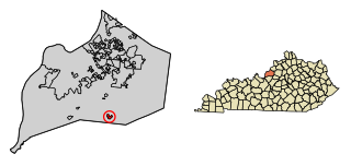
Heritage Creek is a home rule-class city in Jefferson County, Kentucky, United States. The population was 1,076 at the 2010 census, down from 2,560 at the 2000 census.

Plantation is a home rule-class city in Jefferson County, Kentucky, United States, and a part of the Louisville Metro government. The population was 832 at the 2010 census, down from 902 at the 2000 census.
Lakewood Township is a township in Saint Louis County, Minnesota, United States. The population was 2,252 in 2018 as estimated by the Minnesota State Demographic Center.
Chevy Chase is a neighborhood in southeastern Lexington, Kentucky, United States. Its boundaries are Cooper Drive to the south, Tates Creek Road to the west, Fontaine Road to the north, and Chinoe Road to the east.
Deerfield is a neighborhood in southwestern Lexington, Kentucky, United States. Its boundaries are Nicholasville Road to the east, Cincinnati Southern Railroad tracks to the west, Pasadena Drive to the north, and New Circle Road to the south.
Open Gates is a neighborhood in southwestern Lexington, Kentucky, United States. Its boundaries are New Circle Road to the south, Clays Mill Road to the west, Norfolk Southern railroad tracks to the east, and Pasadena Drive to the north.
Wellesley Heights is a neighborhood in southwestern Lexington, Kentucky, United States. It is one of only three rural subdivisions in Fayette County - to protect farmland from development they are now illegal to build. Wellesley Heights is located on the southside of Versailles Road between New Circle Road and Man O War Boulevard. It is surrounded by farmland.
Indian Hills is a subdivision of Lexington, Kentucky, United States. It is bounded by New Circle Road and Harrodsburg Road. Its southern boundary varies depending on the development rates of it and the neighboring Stonewall neighborhood. Indian Hills is the latest to be built.
Wyndham Downs is a neighborhood in southwestern Lexington, Kentucky, United States. Its boundaries are Man O War Boulevard and Old Higbee Mill Road to the north, Twain Ridge Road to the south, Clays Mill Road to the east, and Clemens Drive to the west.
Clemens Heights is a neighborhood in southwestern Lexington, Kentucky, United States. Its streets are all named after things associated with Mark Twain, whose real name was Samuel Clemens. Its boundaries are Old Higbee Mill Road to the north, Clemens Drive and Carevares Drive to the east, Copper Run Boulevard to the south, and Dogwood Park to the west.
Mason Headley is a neighborhood in southwestern Lexington, Kentucky, United States. Its boundaries are Mason Headley Road to the north, Laurel Hill Road to the south, Beacon Hill Drive to the west, and Cold Harbor Drive to the east.
Spindletop is a rural neighborhood north of Lexington, Kentucky, United States. Its boundaries are I-75 to the west and Berea Road to the south and east. It is located just south of the Kentucky Horse Park. It is named for Spindletop hall, a historic mansion once owned by Miles Franklin Yount, which is located within the neighborhood.
Seven Parks is a neighborhood in southwestern Lexington, Kentucky, United States. Its boundaries are Nicholasville Road to the east, Norfolk Southern railroad tracks to the west, Dantzler Drive to the north, and Arcadia Park Drive to the south.
Cherokee Park is a neighborhood in southwestern Lexington, Kentucky, United States. Its boundaries are Rosemont Garden on the south, Nicholasville Road to the east, Dantzler Drive, and the Norfolk Southern railroad tracks to the west. It was developed by Dean William S. Taylor in the early 1920s.
WGPL is a neighborhood in southwestern Lexington, Kentucky, United States. Its name is an acronym for the main streets in the neighborhood - Wabash Drive, Goodrich Avenue, Pensacola Drive and Lackawanna Drive. It is located between Rosemont Garden, Southland Drive, Nicholasville Road, and the Norfolk Southern railroad tracks. WGPL is part of a larger neighborhood in Lexington called Pensacola Park, which includes Suburban Court, Rosemont Garden, and Penmoken Park, according to the Fayette County Property Value Administrator.
Liberty Heights is a neighborhood in southeastern Lexington, Kentucky, United States. Its boundaries are Winchester Road to the north, New Circle Road to the east, and R. J. Corman railroad tracks to the west and south.
Meadowthorpe is a neighborhood in western Lexington, Kentucky, United States. Its boundaries are Leestown Road to the south, New Circle Road to the west, and Norfolk Southern railroad tracks to the north and east. Since 2000, areas south of Leestown Road have seen residential and commercial development in Townley Center. This area is not a part of the Meadowthorpe neighborhood. Schools in the area are Meadowthorpe Elementary and Leestown Middle School.
Shadeland is a neighborhood in southeastern Lexington, Kentucky, United States. Its boundaries are the University of Kentucky Arboretum to the north and west, Glendover Road to the south, and Tates Creek Road to the east.
Montclair is a neighborhood in southeastern Lexington, Kentucky, United States. Its boundaries are Providence Road to the north, Montclair Drive to the south, Tates Creek Road to the east, and the University of Kentucky to the west.
Woodward Heights is a neighborhood and historic district located immediately west of downtown Lexington, Kentucky. It is bounded by Maxwell Street and the Pleasant Green Hill neighborhood to the southwest, by the parking lot for Rupp Arena to the southeast, by the Lexington Convention Center property to the northeast, and by Herlihy, Cox, and High Streets to the north.


