Related Research Articles

Chevy Chase Section Five is an incorporated village in Montgomery County, Maryland, United States. The population was 672 at the 2020 census.

Chevy Chase Section Three is a village in Montgomery County, Maryland, United States. It was organized as a special tax district in 1916 and incorporated as a village in 1982. The population was 802 at the 2020 census.

Chevy Chase View is a town in Montgomery County, Maryland, United States. Established as a Special Tax District in 1924, the town was formally incorporated on October 28, 1993. The population was 1,005 at the 2020 census.

Chevy Chase Village is an incorporated municipality in Montgomery County, Maryland, United States, bordering Washington, D.C. It is made up of sections 1, 1a, and 2 of Chevy Chase, as originally designated by The Chevy Chase Land Company. The population was 2,049 as of the 2020 census. The town was the wealthiest in Maryland as of 2017, with a median income of over $250,000, the highest income bracket listed by the census bureau, and a median home value of $1,823,800.

Friendship Heights Village is an urbanized, unincorporated area in Montgomery County, Maryland, United States. It is distinct from the Washington, D.C., neighborhood of Friendship Heights. Friendship Heights Village is a census-designated place (CDP), with a population of 5,360 at the 2020 census.

North Chevy Chase is a village in Montgomery County, Maryland, United States. It was established as a special tax district in 1924 and incorporated as a village in 1996. The population was 682 at the 2020 census, up from 519 in 2010.

Chevy Chase is an incorporated town in Montgomery County, Maryland, United States. The population was 2,904 at the 2020 census.

Northwest is the northwestern quadrant of Washington, D.C., the capital of the United States, and is located north of the National Mall and west of North Capitol Street. It is the largest of the four quadrants of the city, and it includes the central business district, the Federal Triangle, and the museums along the northern side of the National Mall, as well as many of the District's historic neighborhoods.

Chevy Chase is a neighborhood in northwest Washington, D.C. It borders Chevy Chase, Maryland, a collection of similarly affluent neighborhoods.

Neighborhoods in Washington, D.C., United States are distinguished by their history, culture, architecture, demographics, and geography. The names of 131 neighborhoods are unofficially defined by the D.C. Office of Planning. Neighborhoods can be defined by the boundaries of wards, historic districts, Advisory Neighborhood Commissions, civic associations, and business improvement districts (BIDs); these boundaries will overlap. The eight wards each elect a member to the Council of the District of Columbia and are redistricted every ten years.

Connecticut Avenue is a major thoroughfare in the Northwest quadrant of Washington, D.C., and suburban Montgomery County, Maryland. It is one of the diagonal avenues radiating from the White House, and the segment south of Florida Avenue was one of the original streets in Pierre (Peter) Charles L'Enfant's plan for Washington. A five-mile segment north of Rock Creek was built in the 1890s by a real-estate developer.

Ashland Park is a historic early 20th century neighborhood in Lexington, Kentucky, United States. It was named after Ashland, the estate of Kentucky statesman Henry Clay which is located in the eastern portion of the neighborhood. The 600-acre (2.4 km2) development was designed by the famous landscape architecture firm the Olmsted Brothers of Massachusetts. The neighborhood belongs to the National Register of Historic Places.

Gratz Park is a neighborhood and historic district located just north of downtown Lexington, Kentucky. It was named after early Lexington businessman Benjamin Gratz whose home stands on the corner of Mill and New streets at the edge of Gratz Park. The Gratz Park Historic District consists of 16 contributing buildings including the Hunt-Morgan House, the Bodley-Bullock House, the original Carnegie Library in Lexington, and several other private residences. Gratz Park occupies a tract of land that was established in 1781 outside the original boundaries of Lexington.

Athmar Park is a residential neighborhood in southwest Denver, Colorado. It consists mostly of all-brick ranches and bungalow-style homes built in the 1940s and 1950s.

Bell Court is a neighborhood and historic district immediately southeast of Downtown Lexington, Kentucky, United States. Its boundaries are East Main Street to the south, Walton Avenue to the south, Midland Avenue to the north, and Boonesborough Avenue to the east.
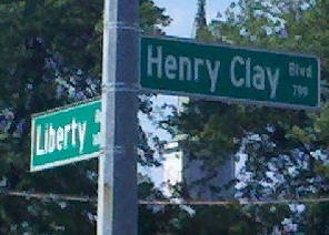
Chevy Chase is a neighborhood in southeastern Lexington, Kentucky, United States. Its boundaries are Cooper Drive to the south, Tates Creek Road to the west, Fontaine Road to the north, and Chinoe Road to the east.
South Broadway Park is a neighborhood in southwestern Lexington, Kentucky, United States. Its boundaries are Bucoto Court to the north, Norfolk Southern railroad tracks to the east, South Broadway to the west, and Virginia Avenue to the south. It is located just west of the University of Kentucky.
WGPL is a neighborhood in southwestern Lexington, Kentucky, United States. Its name is an acronym for the main streets in the neighborhood - Wabash Drive, Goodrich Avenue, Pensacola Drive and Lackawanna Drive. It is located between Rosemont Garden, Southland Drive, Nicholasville Road, and the Norfolk Southern railroad tracks. WGPL is part of a larger neighborhood in Lexington called Pensacola Park, which includes Suburban Court, Rosemont Garden, and Penmoken Park, according to the Fayette County Property Value Administrator.
Liberty Heights is a neighborhood in southeastern Lexington, Kentucky, United States. Its boundaries are Winchester Road to the north, New Circle Road to the east, and R. J. Corman railroad tracks to the west and south.
References
- 1 2 Woodland Park-Aylesford Neighborhood Profile Retrieved 2013-06-22.


| | This Fayette County, Kentucky state location article is a stub. You can help Wikipedia by expanding it. |