Related Research Articles
Ardentown is a village in New Castle County, Delaware, United States. According to the 2010 Census, the population of the village is 264.
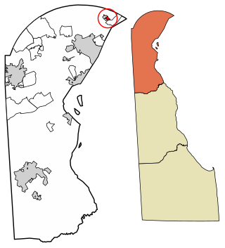
Claymont is a census-designated place (CDP) in New Castle County, Delaware. As of the 2020 U.S. census, the population of Claymont was 9,895.
Highland Parks is a neighborhood in northwest Lexington, Kentucky, United States. It is a new subdivision started in the mid-2000s, located between the older Highlands and Oakwood neighborhoods. It is located south of Birch Drive and north of Boxwood Drive. It is bounded by Georgetown Road to the west and Oakwood Park to the east.
Gardenside is a neighborhood in southwestern Lexington, Kentucky, United States. Its boundaries are a combination of Darien Drive, Traveler Road, Appomattox Drive, and Alexandria Drive to the west, Wolf Run Creek to the north, Beacon Hill Drive to the east, and Lane Allen Road to the south.
Skycrest is a neighborhood in southwestern Lexington, Kentucky, United States. It takes its name from its location on a ridge between Wolf Run Creek and Vaughns Branch Creek that provides a panoramic view downtown Lexington. Its boundaries are Della Drive to the north, Beacon Hill Drive to the west, Furlong Drive and Spring Meadows Drive to the south, and Harrodsburg Road to the east.
Shriners is a neighborhood in southeastern Lexington, Kentucky, United States. It takes its name from the Shriners Hospital for Children located within it. Its boundaries are Richmond Road to the east, Chinoe Road to the north, Cooper Drive to the west, and Lakeview Drive to the south.
Southern Heights is a neighborhood in southwestern Lexington, Kentucky, United States. Its boundaries are the University of Kentucky Arboretum and Central Baptist Hospital to the north, Nicholasville Road to the west, and Edgemoor Drive/Blueberry Road to the south.
Zandale is a neighborhood in southeastern Lexington, Kentucky, United States. Its boundaries are Nicholasville Road to the west, Zandale Drive to the north, Bellefonte Drive to the east, and a combination of Larkin Road, Heather Way, Melbourne Way, and Lowry Lane to the south.
Copperfield is a neighborhood in southwestern Lexington, Kentucky, United States. Its boundaries are the Jessamine County line to the south, Clays Mill Road to the east, Twain Ridge Road to the north, and Calevares Drive to the west.
Wyndham Downs is a neighborhood in southwestern Lexington, Kentucky, United States. Its boundaries are Man O War Boulevard and Old Higbee Mill Road to the north, Twain Ridge Road to the south, Clays Mill Road to the east, and Clemens Drive to the west.
Clemens Heights is a neighborhood in southwestern Lexington, Kentucky, United States. Its streets are all named after things associated with Mark Twain, whose real name was Samuel Clemens. Its boundaries are Old Higbee Mill Road to the north, Clemens Drive and Carevares Drive to the east, Copper Run Boulevard to the south, and Dogwood Park to the west.
Mason Headley is a neighborhood in southwestern Lexington, Kentucky, United States. Its boundaries are Mason Headley Road to the north, Laurel Hill Road to the south, Beacon Hill Drive to the west, and Cold Harbor Drive to the east.
Rosemill is a neighborhood in southwestern Lexington, Kentucky, United States. Its boundaries are Southland Drive and Rosemont Garden to the north, Clays Mill Road to the west, and Hill-N-Dale Road to the south. Lexington Catholic High School has been located in the center of the neighborhood since 1957.
Seven Parks is a neighborhood in southwestern Lexington, Kentucky, United States. Its boundaries are Nicholasville Road to the east, Norfolk Southern railroad tracks to the west, Dantzler Drive to the north, and Arcadia Park Drive to the south.
WGPL is a neighborhood in southwestern Lexington, Kentucky, United States. Its name is an acronym for the main streets in the neighborhood - Wabash Drive, Goodrich Avenue, Pensacola Drive and Lackawanna Drive. It is located between Rosemont Garden, Southland Drive, Nicholasville Road, and the Norfolk Southern railroad tracks. WGPL is part of a larger neighborhood in Lexington called Pensacola Park, which includes Suburban Court, Rosemont Garden, and Penmoken Park, according to the Fayette County Property Value Administrator.
Gainesway is a neighborhood in southeastern Lexington, Kentucky, United States. Its boundaries are New Circle Road to the north, Tates Creek Road to the west, Armstrong Mill Road to the south, and a combination of Pimlico Parkway and Bold Bidder Drive to the east.
Montclair is a neighborhood in southeastern Lexington, Kentucky, United States. Its boundaries are Providence Road to the north, Montclair Drive to the south, Tates Creek Road to the east, and the University of Kentucky to the west.
Brigadoon is a neighborhood in southeastern Lexington, Kentucky, United States. its boundaries are Reynolds Road to the north, Lansdowne Drive to the east, Wilson Downing Road to the south, and Nicholasville Road to the west.
Castlegate is a neighborhood in southeastern Lexington, Kentucky, United States. its boundaries are Alumni Drive to the north and east, Chinoe Road to the west, and a combination of Colt Neck Lane and Lakeside Drive to the south.
Pasadena is a neighborhood in southwestern Lexington, Kentucky, United States. Its name is derived from its location just south of Pasadena Drive. All streets in the neighborhood are named after western American cities. Its boundaries are a combination of New Circle Road, Waco Road, and Nakomi Drive to the south, Harrodsburg Road to the west, Pasadena Drive to the north, and a combination of Waco Road and Clays Mill Road to the east.
References
- 1 2 Claymont Neighborhood Profile Retrieved 2013-08-09.


| | This Fayette County, Kentucky state location article is a stub. You can help Wikipedia by expanding it. |