
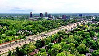
Warren is a city in Macomb County in the U.S. state of Michigan. An inner-ring suburb of Detroit, Warren borders Detroit to the north, roughly 13 miles (20.9 km) north of downtown Detroit. As of the 2020 census, the city had a population of 139,387, making it the largest community in Macomb County, the third-largest city in Michigan, after Detroit and Grand Rapids, and Detroit's largest suburb.

Strasburg is a borough in Lancaster County, Pennsylvania, United States. It developed as a linear village stretching approximately 2 miles (3 km) along the Great Conestoga Road, later known as the Strasburg Road. The population was 3,117 at the 2020 census.
Oakland County is a county in the U.S. state of Michigan. It is a principal county of the Detroit metropolitan area, containing the bulk of Detroit's northern suburbs. Its county seat is Pontiac, and its largest city is Troy. As of the 2020 Census, its population was 1,274,395, making it the second-most populous county in Michigan, and the largest county in the United States without a city of 100,000 residents.

Macomb County is a county located in the eastern portion of the U.S. state of Michigan, bordering Lake St. Clair, and is part of northern Metro Detroit. As of the 2020 Census, the population was 881,217, making it the third-most populous county in the state. The county seat is Mt. Clemens. Macomb County is part of the Detroit-Warren-Dearborn, MI Metropolitan Statistical Area. The city of Detroit is located on the county's southern border. Macomb County contains 27 cities, townships and villages, including three of the top ten most-populous municipalities in Michigan as of the 2010 census: Warren (#3), Sterling Heights (#4) and Clinton Township (#10). Most of this population is concentrated south of Hall Road (M-59), one of the county's main thoroughfares.

Macomb Township is a civil township of Macomb County in the U.S. state of Michigan. The population was 91,663 at the 2020 census, up from 79,580 in 2010. As of 2020 it was the most-populous civil township in the state and the third most-populous township overall after the charter townships of Clinton and Canton.
Roseville is a city in Macomb County in the U.S. state of Michigan. A northern suburb of Detroit, Roseville is located roughly 13 miles (20.9 km) northeast of downtown Detroit. As of the 2020 census, the city had a population of 47,710.

Sterling Heights is a city in Macomb County of the U.S. state of Michigan, and a suburb of Detroit. As of the 2020 census, the city had a total population of 134,346. It is the second largest suburb in Metro Detroit, and the fourth largest city in Michigan.

Southfield is a city in Oakland County in the U.S. state of Michigan. An inner-ring suburb of Detroit, Southfield borders Detroit to the north, lying roughly 15 miles (24.1 km) northwest of downtown. As of the 2020 census, the city had a population of 76,618.

Troy is a city in Oakland County in the U.S. state of Michigan. A northern suburb of Detroit, Troy is located about 22 miles (35 km) north of downtown Detroit. As of the 2020 census, the city had a population of 87,294, making Troy the largest community in Oakland County, and the 13th-most-populous municipality in the state.

Redford Township is a charter township in Wayne County in the U.S. state of Michigan. An inner-ring suburb of Detroit, Redford borders Detroit to the west, roughly 15 miles (24.1 km) northwest of downtown Detroit. As of the 2020 census, the township had a population of 49,504.

Taylor is a city in Wayne County in the U.S. state of Michigan. Its population was 63,409 at the 2020 census. Taylor is the fifth most-populated city in Wayne County and the 17th most-populated city in Michigan.

Paradise is an unincorporated town and census-designated place (CDP) in Clark County, Nevada, United States, adjacent to the city of Las Vegas. It was formed on December 8, 1950. Its population was 191,238 at the 2020 census, making it the fifth-most-populous CDP in the United States; if it were an incorporated city, it would be the fifth-largest in Nevada. As an unincorporated town, it is governed by the Clark County Commission with input from the Paradise Town Advisory Board.

Penn Hills is a township with home rule status in Allegheny County, Pennsylvania, United States. The population was 41,059 as of the 2020 census. A suburb of Pittsburgh, Penn Hills is the second-largest municipality in Allegheny County.

Centre Township is a township in Berks County, Pennsylvania, United States. The population was 4,140 at the 2020 census. It is in Schuylkill Valley School District.

Lower Macungie Township is a township in Lehigh County, Pennsylvania. The township's population was 31,964 as of the 2020 census, making it the second-largest population center in Lehigh County after Allentown and the third-largest population center in the Lehigh Valley metropolitan area after Allentown and Bethlehem.
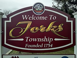
Forks Township is a township in Northampton County, Pennsylvania. The population of Forks Township was 14,721 as of the 2010 census. It is part of the Lehigh Valley metropolitan area, which had a population of 861,899 and was the 68th-most populous metropolitan area in the U.S. as of the 2020 census. The township is home to the global headquarters of Crayola, founded in 1885, a global arts supply company and the world's leading manufacturer of crayons.

Hanover Township is a township in Northampton County, Pennsylvania. The population of Hanover Township was 10,866 at the 2010 census.

Palmer Township is a township in Northampton County, Pennsylvania. The population of Palmer Township was 20,691 at the 2010 census.
Six Mile Run is an unincorporated community and census-designated place (CDP) located in Franklin Township, in Somerset County, in the U.S. state of New Jersey. As of the 2010 United States Census, the CDP's population was 3,184.

Estrée-Cauchy is a commune in the Pas-de-Calais department in the Hauts-de-France region of France.


