Related Research Articles

Lansing is the capital of the U.S. state of Michigan. It is mostly in Ingham County, although portions of the city extend west into Eaton County and north into Clinton County. The 2020 census placed the city's population at 112,644, making it the sixth most populous city in Michigan. The population of its metropolitan statistical area (MSA) was 541,297 at the 2020 census, the third largest in the state after metropolitan Detroit and Grand Rapids. It was named the new state capital of Michigan in 1847, ten years after Michigan became a state.
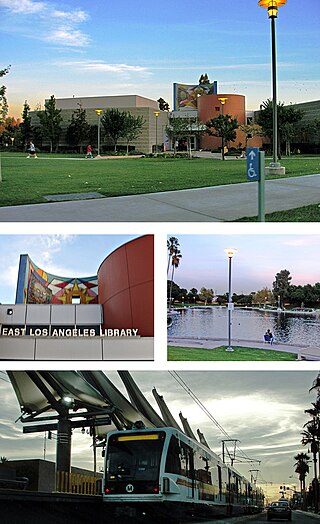
East Los Angeles, or East L.A., frequently recognized by locals as "East LA," is an unincorporated area situated within Los Angeles County, California, United States. According to the United States Census Bureau, East Los Angeles is designated as a census-designated place (CDP) for statistical purposes. The most recent data from the 2020 census reports a population of 118,786, reflecting a 6.1% decrease compared to the 2010 population of 126,496.

West Homestead is a borough in Allegheny County, Pennsylvania, United States, 8 miles (13 km) southeast of Pittsburgh, on the Monongahela River. Heavy industries associated with nearby steel mills existed here, such as axle works, brickworks, and manufactories of machinery, car wheels, etc. The largest concern was Mesta Machinery, which was one of the world's leading industrial manufacturers from 1898 until 1983. The population was 1,872 at the 2020 census.

The Eastside is an urban region in Los Angeles County, California. It includes the Los Angeles City neighborhoods east of the Los Angeles River—that is, Boyle Heights, El Sereno, and Lincoln Heights—as well as unincorporated East Los Angeles.

Manhattan Community Board 5 is a New York City community board, part of the local government apparatus of the city, with the responsibility for the neighborhoods of Midtown, Times Square, most of the Theater District, the Diamond District, the Garment District, Herald Square, Koreatown, NoMad, Murray Hill and the Flatiron District, all in the borough of Manhattan. It is bounded by 59th Street on the north, Eighth Avenue, 26th Street, the Avenue of the Americas on the west, 14th Street on the south, and Lexington Avenue on the east, excluding the area from 34th to 40th Streets between Madison and Lexington Avenues, and the area from 20th to 22nd Streets between Park Avenue South and Lexington Avenue/Irving Place.

Eastside Park is a residential neighborhood in the Eastside of Paterson, New Jersey. The Eastside Park section of the city is generally defined as the area of the city bordered by Vreeland Avenue and East 33rd Street to the west, 20th Avenue to the south, McLean Boulevard to the east, and Martin Luther King, Jr. Way (Broadway) to the north. The Eastside Park section is delineated from the Manor section of the city by Broadway, which becomes Route 4 before crossing the Passaic River into Elmwood Park in Bergen County.

Fountain Square is one of seven designated cultural districts in Indianapolis, Indiana. Located just outside the city's downtown district, Fountain Square is home to three designated national historic districts, the Laurel and Prospect, the State and Prospect, and the Virginia Avenue districts, all of which were listed on the National Register of Historic Places in 1983. The neighborhood derives its name from the successive fountains that have been prominently featured at the intersection of Virginia Avenue, East Prospect Street, and Shelby Street.

Black Pearl is a neighborhood of the city of New Orleans. A subdistrict of the Uptown/Carrollton Area, its boundaries as defined by the New Orleans City Planning Commission are: South Carrollton Avenue and St. Charles Avenue to the north, Lowerline, Perrier and Broadway Streets to the east, and the Mississippi River to the west.

Edgewater is a neighborhood in Miami, Florida, located north of Downtown and the Arts & Entertainment District, and south of Midtown and the Upper Eastside. It is roughly bound by North 17th Street to the south, North 37th Street to the north, the Florida East Coast Railway and East First Avenue to the west and Biscayne Bay to the east.

Milan is a neighborhood of the city of New Orleans, Louisiana, U.S.A. A sub-district of the Central City/Garden District Area, its boundaries as defined by the New Orleans City Planning Commission are: South Claiborne Avenue to the north, Toledano Street and Louisiana Avenue to the east, St. Charles Avenue to the south, and Napoleon Avenue to the west.

Northeast Los Angeles is a 17.18 sq mi (44.5 km2) region of Los Angeles County, comprising seven neighborhoods within Los Angeles. The area is home to Occidental College located in Eagle Rock.
Maryland Manor is a neighborhood in the southern area of Tampa, Florida, which represents District 4 of the Tampa City Council. The 2000 census numbers were unavailable, however, the latest estimated population was 1,616.

Bell Court is a neighborhood and historic district immediately southeast of Downtown Lexington, Kentucky, United States. Its boundaries are East Main Street to the south, Walton Avenue to the south, Midland Avenue to the north, and Boonesborough Avenue to the east.
Kenwick is a neighborhood in southeastern Lexington, Kentucky, United States. Its boundaries are Sherman Avenue to the south, East Main Street to the west, railroad tracks to the north, and Richmond Avenue to the north.

Macfarlane Park is a neighborhood in the West Tampa district of Tampa, Florida, which represents District 6 of the Tampa City Council. The 2000 census numbers were unavailable; however, the latest estimated population was 1,754.
Woodland Park is a neighborhood located immediately south of downtown Lexington, Kentucky, United States. It is composed of several small neighborhood associations. The neighborhood is alternatively named Aylesford and is sometimes referred to by locals as "Chevy Chase". However, Chevy Chase is actually a separate neighborhood located southeast of Woodland Park.

Northside is a neighborhood in northern Lexington, Kentucky, United States. Its boundaries are Loudon Avenue to the north and east, Short Street, Midland Avenue, and Winchester Road to the south, and Newtown Pike to the west.
East César Chávez is a neighborhood in Austin, Texas. It is located in the central-east part of Austin's urban core on the north bank of the Colorado River. The neighborhood encompasses much of ZIP code 78702.

Harvard Park is a 0.64-square-mile neighborhood in the South Los Angeles region of Los Angeles, California.
References
- ↑ Eastside Neighborhood Profile Retrieved 2013-05-16.


| | This Fayette County, Kentucky state location article is a stub. You can help Wikipedia by expanding it. |