Valley View Ferry

Last updated
Valley View Ferry
Valley View Ferry.jpg
Waterway Kentucky River
Transit type Cable ferry
Owner Lexington-Fayette Urban County Government and Madison and Jessamine Counties
OperatorSame as owner
Began operation1785
Travel time2-3 minutes
No. of vesselsOne
No. of terminalsTwo
Daily ridership350 passengers on average

The Valley View Ferry provides passage over the Kentucky River in rural central Kentucky. Located on Kentucky Route 169, this ferry service connects auto traffic between the county seats of Richmond in Madison County, Nicholasville in Jessamine County and Lexington Kentucky. The route leads you directly to downtown Richmond, Lexington and Nicholasville.

Contents

The ferry was founded in 1780, predating Kentucky's admission to the Union in 1792. It is widely regarded as the commonwealth's oldest continually operating business. [1]

John Craig, a Virginia veteran of the Revolutionary War, acquired land in the area in 1780 through a military warrant. In 1785, the Virginia General Assembly granted Craig "a perpetual and irrevocable" franchise to operate a ferry. [2] Daniel Boone, Henry Clay, James Mason and Ulysses S. Grant were among its passengers. [3] The ferry remained a privately owned business for more than 200 years, passing through the hands of seven successive families until 1991. It was then purchased jointly by the Lexington-Fayette Urban County Government and Madison and Jessamine counties for $60,000. [1]

The rudderless ferry is guided by cables stretching between four 55-foot towers. The entire ferry site was renovated in 1998, when authorities replaced the four towers and their cables. Two years later, the ferry authority received a federal grant allowing an upgrade of the barge. The new vessel, longer than its predecessor by ten feet, enables the ferry to carry three cars instead of two. [4]

The Kentucky Transportation Cabinet funds the ferry as a free service. On average it transports 250 cars a day. [3]

Operations

Valley View Ferry Valley-view-ferry-2.png
Valley View Ferry

There are 2 captains: Clayton Embly, a long time mariner in the Military Sealift Command; and Shane Toomey, who started his young career on the Valley View Ferry, working the way up to his license. There are four full time deckhands and 2 on call as needed. The deckhands used to be inmates provided by local jails. In 2020 the board did away with inmates for paid deckhands.

Two John Deere engines power the boats generator which in turn powers the mechanics. Only one engine is used at a time. The paddle wheel is controlled by hydraulic motors which with the new rework in 2023 moves the boat across the river in about 2 minutes 30 seconds with a full load. The ramps are controlled by compressed air allowing the barge to slip off the terminal. This set up allows the engines to run at a low RPM extending their life’s and making them more fuel efficient.

The ferry operates 12 hours a day everyday, except Christmas, Unless bad weather permits them from operating. The schedule is 6am-6pm Monday thru Friday; 8am-8pm Saturday and Sunday.

Boat history

The current tug named the “John Craig II” after the boat before it. It was placed in the water December of 2014. The John Craig II is the biggest tug the ferry has ever had at 25.5ft long. Weighing approximately 48,000 pounds.

the John Craig II has two motors, compared to the John Craig’s single motor, which will give the ferry a backup with one motor has mechanical problems. A different motor will be used each day, and resting the motors will prolong their lives. [5]

The John Craig II costed a total of $700,000 to build. $600,000 in federal grants and $100,000 in local funding. In January of 2023 the boat was hauled out for major rework and repairs. Captain Shane Toomey said “The internals and mechanics are all new. The paint job is fresh and the people are waiting. The frame work is the only thing not new and even that got a lot of work done to it”. In June of 2023 the board along with the captains started talking about a new barge.

A tug named the "John Craig" after the franchise's original owner, dates to 1996. The vessel it replaced sustained heavy damage after sinking under the weight of a heavy snowfall and then as a result of salvage efforts. [6]

The ferry appeared in background scenes of the 1967 Irvin Kershner film The Flim-Flam Man .

Related Research Articles

<span class="mw-page-title-main">Lexington, Kentucky</span> City in Kentucky, United States

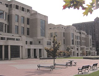
Lexington is a city in the Commonwealth of Kentucky, and the county seat of Fayette County. By population, it is the 2nd most populous city in Kentucky after Louisville and 60th-most populous city in the United States. By land area, it is the country's 30th-largest city. The city is also known as "Horse Capital of the World". It is within the state's Bluegrass region. Notable locations within the city include the Kentucky Horse Park, The Red Mile and Keeneland race courses, Rupp Arena, Central Bank Center, Transylvania University, the University of Kentucky, Bluegrass Community and Technical College, and the National Thoroughbred Racing Association (NTRA) Headquarters.

<span class="mw-page-title-main">Madison County, Kentucky</span> County in Kentucky, United States

Madison County is a county located in the central part of the U.S. state of Kentucky. At the 2020 census, its population was 92,701. Its county seat is Richmond. The county is named for Virginia statesman James Madison, who later became the fourth President of the United States.

<span class="mw-page-title-main">Jessamine County, Kentucky</span> County in Kentucky, United States

Jessamine County is a county located in the U.S. state of Kentucky. As of the 2020 census, the population was 52,991. Its county seat is Nicholasville. The county was founded in December 1798. Jessamine County is part of the Lexington-Fayette, KY Metropolitan Statistical Area. It is within the Inner Blue Grass region, long a center of farming and blooded stock raising, including thoroughbred horses. The legislature established a commercial wine industry here in the late 18th century.

<span class="mw-page-title-main">Fayette County, Kentucky</span> County in Kentucky, United States

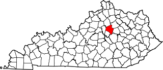
Fayette County is located in the central part of the U.S. state of Kentucky and is consolidated with the city of Lexington. As of the 2020 census, the population was 322,570, making it the second-most populous county in the commonwealth. Since 1974, its territory, population and government have been shared with Lexington. Fayette County is part of the Lexington-Fayette, KY Metropolitan Statistical Area.

<span class="mw-page-title-main">Nicholasville, Kentucky</span> City in Kentucky, United States

Nicholasville is a home rule city in and the county seat of Jessamine County, Kentucky. The population was 31,490 during the 2020 U.S. census, making Nicholasville the 10th-largest settlement in the state.

<span class="mw-page-title-main">New Circle Road</span> Highway in Lexington, Kentucky

New Circle Road, also known as Kentucky Route 4, is a Kentucky state highway that serves as an inner beltway around Lexington, which is part of the consolidated city-county government with Fayette County.

Lexington Mall was a small shopping mall located in Lexington, Kentucky along US 25/US 421. The mall portion was built in 1975.

<span class="mw-page-title-main">Area code 859</span> Area code that serves the city of Lexington and the central portion of Kentucky

Area code 859 is a telephone area code in the North American Numbering Plan (NANP) for the city of Lexington and the central portion of the Commonwealth of Kentucky. It was created in a split from area code 606 in 1999.

<span class="mw-page-title-main">Man o' War Boulevard</span>

Man o' War Boulevard, named after the racehorse Man o' War, is an almost 17-mile (27 km) urban arterial, circling Lexington, Kentucky to its south. Its western terminus is at US 60 / Keeneland Boulevard at Keeneland Race Course's main entrance, from which the highway heads southeast, intersecting with US 68, US 27, and other roads. It then turns east and northeast, intersecting KY 1974, US 25/US 421, and I-75, before ending at US 60 at Brighton. The majority of the road is a four-lane divided highway with curbs and sidewalks maintained by the Lexington-Fayette Urban County Government, but the 1.429-mile (2.300 km) portion east of I-75 is maintained by the Kentucky Transportation Cabinet as Supplemental Road Kentucky Route 1425, and only carries two lanes.

<span class="mw-page-title-main">Cityscape of Lexington, Kentucky</span> Architecture and urbanism in Lexington, Kentucky (USA)

The urban development patterns of Lexington, Kentucky, confined within an urban growth boundary that protects its famed horse farms, include greenbelts and expanses of land between it and the surrounding towns. This has been done to preserve the region's horse farms and the unique Bluegrass landscape, which bring millions of dollars to the city through the horse industry and tourism. Urban growth is also tightly restricted in the adjacent counties, with the exception of Jessamine County, with development only allowed inside existing city limits. In order to prevent rural subdivisions and large homes on expansive lots from consuming the Bluegrass landscape, Fayette and all surrounding counties have minimum lot size requirements, which range from 10 acres (40,000 m2) in Jessamine to fifty in Fayette.

<span class="mw-page-title-main">Kentucky Route 39</span> Highway in Kentucky, U.S.

Kentucky Route 39 is a state highway in the U.S. state of Kentucky. The route, part of the State Secondary System, exists in two segments, separated at the Madison-Jessamine county line by the Kentucky River. While there is a boat ramp on each side, there is no bridge or ferry carrying vehicular traffic across the waterway. The southernmost terminus of the route is at Kentucky Route 1247 in Somerset. The northernmost terminus is at U.S. Route 27 Business and Kentucky Route 29 in Nicholasville.

<span class="mw-page-title-main">Alexander Keith Marshall</span> American politician

Alexander Keith Marshall was an American physician who became aligned with the Know Nothing Party and served as single term as United States Representative from Kentucky.

<span class="mw-page-title-main">John C. Watts</span> American politician

John Clarence Watts was a U.S. Representative from Kentucky.

<span class="mw-page-title-main">Ferries and steamboats of Lake Crescent, Washington</span> Defunct ferry system in Washington state

Ferries and steamboats of Lake Crescent, Washington were used for water transport of passengers and freight before highways were built in the area in the early 1920s. Prior to highway construction, Lake Crescent was used as a route from Port Townsend into the northwestern part of the Olympic Peninsula. Ferries, steamboats and similar water craft were built and used on the lake until the Olympic Highway was completed along the south shore of the lake in 1922.

<span class="mw-page-title-main">National Register of Historic Places listings in Fayette County, Kentucky</span>

This is a list of the National Register of Historic Places listings in Fayette County, Kentucky.

<span class="mw-page-title-main">U.S. Route 27 in Kentucky</span>

U.S. Route 27 (US 27) in Kentucky runs 201.120 miles (323.671 km) from the Tennessee border to the Ohio border at Cincinnati. It crosses into the state in the Lake Cumberland area, passing near or through many small towns, including Somerset, Stanford, and Nicholasville. The road then passes straight through the heart of Lexington, including past the University of Kentucky (UK) and Transylvania University. North of Lexington it passes through Cynthiana and Falmouth before entering Campbell County and passing through many Northern Kentucky suburbs before ending at the Ohio state line on the Taylor Southgate Bridge in Cincinnati.

Payne House may refer to:

McConnell House can refer to:

The following is a timeline of the history of Lexington, Kentucky, United States.

References

  1. 1 2 Poor, Chris (1991-07-28). "The Return of the Valley View Ferry: Oldest Business is Back in Business". Lexington Herald-Leader .
  2. On-site historical marker, referenced in Wells, Dianne; Melba Porter Hay; Thomas H. Appleton (2002). Roadside History: A Guide to Kentucky Highway Markers. Frankfort: Kentucky Historical Society. p. 149. ISBN   0-916968-28-6.
  3. 1 2 Hammond, Claude (2004-03-01). "A Kentucky Ferry Tale". Lexington Herald-Leader.
  4. Partridge, Wayne (2000-04-04). "Ferry Good News for Commuters: Valley View Gets Federal Grant to Replace Barge". Lexington Herald-Leader.
  5. Writer, Machaela Ballard / Register News (2014-12-02). "New towboat arrives for Valley View Ferry". Richmond Register. Retrieved 2023-09-03.
  6. Martin, Kimberly N (1996-01-17). "Boat Damage Sinks Historic Ferry Service: 2-Month Shutdown Inconveniencing Passengers". Lexington Herald-Leader.

37°50′50″N84°26′08″W / 37.847224°N 84.435688°W / 37.847224; -84.435688