Related Research Articles
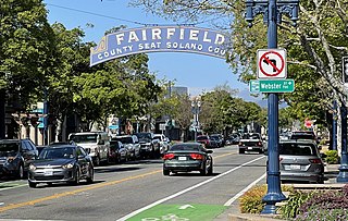
Fairfield is a city in and the county seat of Solano County, California, United States, in the North Bay sub-region of the San Francisco Bay Area. It is generally considered the midpoint between the cities of San Francisco and Sacramento, approximately 40 miles (64 km) from the city center of each city, the same from the city center of Oakland.

North Decatur is a census-designated place (CDP) in DeKalb County, Georgia, United States. The population was 16,698 at the 2010 census.

Riverdale is a city in Scott County, Iowa, United States. The population was 379 at the time of the 2020 census.

Oak Hills is a census-designated place (CDP) and neighborhood in Washington County, Oregon, United States. The CDP population was 9,050 at the 2000 census. It is on unincorporated land north of Beaverton, west of Cedar Mill, and south/southeast of Bethany. The CDP is roughly bounded by the Sunset Highway on the south, West Union Road on the north, Northwest 174th Avenue on the west, and Northwest 143rd Avenue on the east. The U.S. Postal Service has assigned Beaverton addresses to the area. Fire protection and EMS services are provided through Tualatin Valley Fire and Rescue.

Blaine is a suburban city in Anoka and Ramsey counties in Minnesota, United States. Once a rural town, Blaine's population has increased significantly in the last 60 years. For several years, Blaine led the Twin Cities metro region in new home construction. The population was 70,222 at the 2020 census. The city is mainly in Anoka County, and is part of the Minneapolis–Saint Paul metropolitan area.

West Springfield is a city in Hampden County, Massachusetts, United States. It is part of the Springfield, Massachusetts Metropolitan Statistical Area. The population was 28,835 at the 2020 United States Census. The city is also known as "West Side", in reference to the fact that it is on the western side of the Connecticut River from Springfield, a fact which played a major part in the town's early history.

Nether Providence Township is a first class township in Delaware County, Pennsylvania, United States. Many residents refer to the township by the name of its largest community, Wallingford, because the Wallingford postal code is used for most of the township. The population of the township was 13,706 at the 2010 census.

Brightmoor is a neighborhood located in Detroit, Michigan, near the northwest border of the city. Brightmoor is defined by the Brightmoor Alliance as being bordered by Puritan Road to the north, the CSX railway to the south, Evergreen Road to the east, and Outer Drive West, Dacosta Street, and Telegraph Road to the west. However, the demographics given here for the neighborhood are the city's statistical Master Plan Neighborhood area, which consists of eight census tracts that includes some areas outside of the Alliance's boundaries, but does not include some areas within its boundaries.
Joyland is a neighborhood in Northeast Lexington, Kentucky, United States. Its boundaries are I-75/ I-64 to the south, Paris Pike to the east, Russell Cave Road to the west, and the Lexington Urban Growth Boundary to the north. Joyland is the only north Lexington neighborhood to be located entirely north of I-75.
Garden Springs is a neighborhood in Southwestern Lexington, Kentucky, United States. Its boundaries are Georgian Way to the west, Lane Allen Road to the north, Harrodsburg Road to the east, and New Circle Road to the south. Turfland Mall and the Lexington campus of Sullivan University are located in the neighborhood.
Beaumont Park is a neighborhood in southwestern Lexington, Kentucky, United States. Its boundaries are Parkers Mill Road to the west, Lane Allen Road to the north, Lansill Dr to the east, and New Circle Road to the south.
Pine Meadow is a neighborhood in southwestern Lexington, Kentucky, United States. Its boundaries are Mason Headley Road to the west, Pine Meadow Park to the north, Addison Park to the east, and the Campbell House golfcourse to the south.
Cross Keys is a neighborhood in southwestern Lexington, Kentucky, United States. Its boundaries are Traveler Road to the east, Versailles Road to the north, Parks Mill Road to the north, and Lane Allen Road to the south.

Northside is a neighborhood in northern Lexington, Kentucky, United States. Its boundaries are Loudon Avenue to the north and east, Short Street, Midland Avenue, and Winchester Road to the south, and Newtown Pike to the west.
Meadowthorpe is a neighborhood in western Lexington, Kentucky, United States. Its boundaries are Leestown Road to the south, New Circle Road to the west, and Norfolk Southern railroad tracks to the north and east. Since 2000, areas south of Leestown Road have seen residential and commercial development in Townley Center. This area is not a part of the Meadowthorpe neighborhood. Schools in the area are Meadowthorpe Elementary and Leestown Middle School.
Elkhorn Park is a neighborhood in northern Lexington, Kentucky, United States. Its boundaries are Dover Road to the north, North Broadway to the east, New Circle Road to the south, and Russell Cave Road to the west.

Masterson Station is a neighborhood in northwestern Lexington, Kentucky, United States. Its boundaries are Masterson Station Park on the west, Leestown Road to the south, Greendale Road to the east, and Spurr Road to the north.
Highlands is a neighborhood in northwestern Lexington, Kentucky, United States. Its boundaries are Georgetown Road to the west, Oakwood Park to the east, and Citation Boulevard to the east. There are plans to develop a vacant field north of Highlands, it is unclear whether it will become part of Highlands or be a separate neighborhood.
Oakwood is a neighborhood in northwestern Lexington, Kentucky, United States. Its boundaries are Georgetown Road to the west, Oakwood Park to the east, the Nandino Parkway industrial complex to the south, and the newer Highland Park neighborhood to the north.
Andover Hills is a subdivision in southeastern Lexington, Kentucky, United States. Its boundaries are Todds Road to the east, Hays Boulevard to the south, Jacobson Park to the west, and Mapleleaf Park to the north. Schools in the district are Athens Chilesburg Elementary School, Edythe J. Hayes Middle School, and Henry Clay High School.
References
- 1 2 Cardinal Valley Neighborhood Profile city-data.com. Retrieved on 2011-01-02


