
The Odd Fellows' Cemetery Mound is a Native American mound in the southwestern part of the U.S. state of Ohio. Located in the village of Newtown in Hamilton County, the mound is an oval approximately 110 feet (34 m) long and 90 feet (27 m) wide; its height is 11.3 feet (3.4 m). It is believed to have been built by the Adena culture.

The Great Mound is a massive Native American mound in the southwestern part of the U.S. state of Ohio. Located in Section 19 of Madison Township in Butler County, it has a height of 43 feet (13 m) and a circumference of 511 feet (156 m). Its total volume is nearly 825,000 cubic feet (23,400 m3), making it the largest mound in Butler County and one of the largest in southwestern Ohio. Because of the mound's height and its placement on a ridgeline, an individual at the summit can see for a great distance. In the late nineteenth century, it was theorized that mounds such as the Great Mound were built as observation or watch points, and that the builders maintained the ability to light fires atop the mounds as a method of communicating across wide distances. The potential of these mounds for long-distance communication was demonstrated in 1990 by three groups of volunteers. After climbing the Great Mound, the first group established visual contact with the Hill-Kinder Mound in Franklin, from which point the observers of the second group contacted the third group atop the Miamisburg Mound near Dayton.

The Mann Mound is a Native American mound in the southwestern part of the U.S. state of Ohio. Located near the unincorporated community of Jacksonburg in Butler County, it is tree-covered and sits on the edge of a field in Section 12 of Wayne Township. Its height is approximately 20 feet (6.1 m), and its circumference is approximately 540 feet (160 m).

The Williamson Mound Archeological District is an archaeological site in the southwestern part of the U.S. state of Ohio. Located north of Maud in Butler County, the mound appears to have been the work of peoples of the Hopewell tradition.

The Arledge Mounds are a pair of Native American mounds in the south central part of the U.S. state of Ohio. Located near Circleville in Pickaway County, the two mounds lie in the middle of a farm field, far from any roads. These two mounds are disparate in size: while the smaller mound's height is 5 feet (1.5 m), the other's is 20 feet (6.1 m), and their diameters are approximately 65 feet (20 m) and 120 feet (37 m) respectively.
The George Deffenbaugh Mound is a Native American mound in the southeastern part of the U.S. state of Ohio. Located northeast of Laurelville in Hocking County, the mound sits on a ridgeline; it is 6.5 feet (2.0 m) tall and approximately 50 feet (15 m) in diameter. It was first excavated at an unknown date prior to 1941; at this time, a hole was sunk from the mound's crest to its base, and a smaller hole was dug into its edge.
The Kinzer Mound is a Native American mound in Ross County, Ohio, United States. Located outside of the village of South Salem, the mound sits on high ground far from any stream. Built in a sub-conical shape; it is 7.6 feet (2.3 m) tall and has a diameter of approximately 70 feet (21 m).

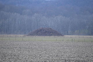
The Horn Mound is a Native American mound in eastern Pickaway County, Ohio, United States. Located near the village of Tarlton, the mound sits along a stream at a significant distance from any other prehistoric sites. It is believed to have been built by people of the Adena culture, who constructed many burial mounds and other ceremonial earthworks in prehistoric Ohio. Although erosion by the nearby stream has the potential of damaging the mound, it appears to be virtually undisturbed by human exploration. Because of its pristine state, the Horn Mound is a likely archaeological site, and for this reason it was listed on the National Register of Historic Places in 1974.
The Zaleski Mound Group is a collection of three burial mounds in the village of Zaleski, Ohio, United States. Built by people of the prehistoric Adena culture, these earthworks are valuable archaeological sites.

The W. C. Clemmons Mound is a Native American mound in the south central portion of the U.S. state of Ohio. Located near the unincorporated community of Fox, it lies in the middle of a farm field near a creek. A cone measuring approximately 22 feet (6.7 m) high and 144 feet (44 m) in diameter, its shape is almost exactly circular.
The Theodore B. Schaer Mound is a Native American mound in the central part of the U.S. state of Ohio. Located southeast of the city of Canal Winchester in Fairfield County, it is a large mound; its height is 13 feet (4.0 m), and it is 60 feet (18 m) in diameter. Today, the mound sits in woodland, being covered with brush and trees. Since white settlement of the region, the mound has seen few changes: individuals hunting for Indian relics have damaged it slightly, but the most significant effects have been minor natural phenomena such as the diggings of groundhogs.
The Old Maid's Orchard Mound is a Native American mound in the central portion of the U.S. state of Ohio. Located near the village of Lithopolis in Fairfield County, the mound lies within the boundaries of Chestnut Ridge Metro Park, in northern Bloom Township.

The Coon Hunters Mound is a Native American mound in the central part of the U.S. state of Ohio. Located near the village of Carroll, it sits on the grounds of the Central Ohio Coonhunters Association.
The Edith Ross Mound is a Native American mound and archaeological site in the southeastern part of the U.S. state of Ohio. Located near the village of Laurelville in Hocking County, the mound is a circular structure that measures 40 feet (12 m) in diameter at its base and 4.6 feet (1.4 m) high at the center. It is constructed primarily of earth, with large stones placed on various parts of the surface. Few changes have been made to the mound since white settlement of the region; a small depression in the northwestern corner may be the result of someone digging, but no significant damage was done.
The Karshner Mound is a Native American mound in the southeastern portion of the U.S. state of Ohio. Located near the village of Laurelville in Hocking County, it is one of Ohio's largest remaining burial mounds that has not been significantly damaged since white settlement. Measuring 100 feet (30 m) in diameter and 28 feet (8.5 m) high, it lies in the middle of a farm field, but it has never been cultivated, and vegetation on the mound has prevented erosion.

The Jackson Mound is a Native American mound in the south-central portion of the U.S. state of Ohio. Located north of Pancoastburg in Fayette County, it measures approximately 75 feet (23 m) in diameter and 5.5 feet (1.7 m) in height. The mound has never been excavated, making the certain identification of its builders impossible; however, its location on a high terrace above a relatively small stream suggests that it was built by the Adena culture, which favored such sites for its many mounds. If true, it was originally more conical in shape, and it is likely to cover the remains of a wooden charnel house built by the Adena.

The Hillside Haven Mound is a Native American mound in the southwestern part of the U.S. state of Ohio. Located southwest of Oakland in Clinton County, it sits in dense woodland on the side of a hill. It is believed to have been conical in shape at the time of construction, but today it is rounded in shape, measuring 2.5 feet (0.76 m) high and 33 feet (10 m) in diameter.

The Mayberry Mound and Village Site are a valuable archaeological site in the southeastern portion of the U.S. state of Illinois. Located near the village of Sims in southern Wayne County, the site comprises what was once a substantial village during the Archaic period, and it has been designated a historic site because of its archaeological importance.

The Wright-Patterson Air Force Base Mound, designated 33GR31, is a Native American mound near the city of Dayton in Greene County, Ohio, United States. Named for its location on an Air Force facility, Wright-Patterson Air Force Base, the mound is an archaeological site.

The Rocky Fork Park Site is an archaeological site in the southeastern part of the U.S. state of Ohio. Located in Rocky Fork State Park in eastern Highland County, the site's earthworks have been designated a historic site because of their archaeological importance.


