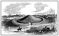
Artist's conception of the Biggs Site | |
 Location within Kentucky today | |
| Location | South Shore, Kentucky, Greenup County, Kentucky, |
|---|---|
| Region | Greenup County, Kentucky |
| Coordinates | 38°44′2.7″N82°56′4″W / 38.734083°N 82.93444°W |
| History | |
| Cultures | Adena culture, Ohio Hopewell culture |
| Site notes | |
| Architecture | |
| Architectural styles | earthworks, causewayed ring ditch |
| Responsible body: private | |
The Biggs Site (15Gp8), also known as the Portsmouth Earthworks Group D, is an Adena culture archaeological site located near South Shore in Greenup County, Kentucky. Biggs was originally a concentric circular embankment and ditch surrounding a central conical burial mound with a causeway crossing the ring and ditch. It was part of a larger complex, the Portsmouth Earthworks, located across the Ohio River and now mostly obliterated by agriculture and the developing city of Portsmouth, Ohio. [1] [2]