The Benham Mound is a Native American mound in the southwestern part of the U.S. state of Ohio. Located in modern Amberley Village in Hamilton County, the mound is an archaeological site.

The Conrad Mound Archeological Site is an archaeological site in the southwestern part of the U.S. state of Ohio. Located east of Cleves in Hamilton County, the site is centered on an isolated Native American mound. Its location atop a ridgeline has been interpreted as evidence that the mound was constructed by the Adena culture. No artifacts have been found at the site, for no archaeological excavation has ever been carried out; however, experience with other sites has led archaeologists to surmise that the mound is surrounded by a larger zone of archaeological interest. Because of its potential archaeological value, the mound was listed on the National Register of Historic Places in 1975.

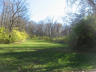
The Mount Nebo Archaeological District is a historic district in the southwestern corner of the U.S. state of Ohio. Located near North Bend, the district lies near the intersection of Mount Nebo and Brower Roads. Included in the district's 40 acres (16 ha) of area are two contributing properties: one large archaeological site and one Native American mound.

The Turpin Site (33Ha28) is an archaeological site in the southwestern portion of the U.S. state of Ohio. Located near Newtown in Hamilton County, the site includes the remains of a village of the Fort Ancient culture and of multiple burial mounds. Detailed explorations of the site have revealed the bodies of many individuals in and around the mounds. The archaeological value of the site has resulted in its use in the study of similar locations and in its designation as a historic site.
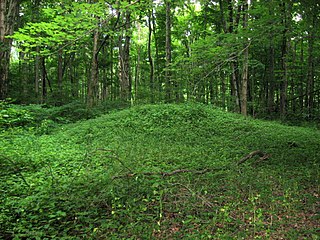
The Demoret Mound is a Native American mound in the southwestern part of the U.S. state of Ohio. Located west of Ross in Butler County, the mound appears to have been constructed by Native Americans of the Woodland period. Although the Demoret Mound has not been excavated, it is likely to contain evidence of funerary practices; excavation of similar mounds has revealed postholes of structures believed to be houses or ceremonial buildings. Consequently, the archaeological value of the mound is significant; excavation might reveal information about practices not found in other mounds. In recognition of its archaeological value, the Demoret Mound was added to the National Register of Historic Places in 1975.

The Great Mound is a massive Native American mound in the southwestern part of the U.S. state of Ohio. Located in Section 19 of Madison Township in Butler County, it has a height of 43 feet (13 m) and a circumference of 511 feet (156 m). Its total volume is nearly 825,000 cubic feet (23,400 m3), making it the largest mound in Butler County and one of the largest in southwestern Ohio. Because of the mound's height and its placement on a ridgeline, an individual at the summit can see for a great distance. In the late nineteenth century, it was theorized that mounds such as the Great Mound were built as observation or watch points, and that the builders maintained the ability to light fires atop the mounds as a method of communicating across wide distances. The potential of these mounds for long-distance communication was demonstrated in 1990 by three groups of volunteers. After climbing the Great Mound, the first group established visual contact with the Hill-Kinder Mound in Franklin, from which point the observers of the second group contacted the third group atop the Miamisburg Mound near Dayton.

The Mann Mound is a Native American mound in the southwestern part of the U.S. state of Ohio. Located near the unincorporated community of Jacksonburg in Butler County, it is tree-covered and sits on the edge of a field in Section 12 of Wayne Township. Its height is approximately 20 feet (6.1 m), and its circumference is approximately 540 feet (160 m).

The Roberts Mound is a Native American mound in the southwestern part of the U.S. state of Ohio, USA. Located northwest of Auburn in Butler County, the mound sits in Section 36 of Reily Township; it is the only mound in the far southeastern part of the township.

This is a list of the National Register of Historic Places listings in Butler County, Ohio.

The Carl Potter Mound is a historic Native American mound in southern Champaign County, Ohio, United States. Located near Mechanicsburg, it lies on a small ridge in a pasture field in southeastern Union Township. In 1974, the mound was listed on the National Register of Historic Places as a potential archaeological site, primarily because of its use as a burial mound.
The David Stitt Mound is a Native American mound near Chillicothe in Ross County, Ohio, United States. Located on elevated land at a significant distance from the Scioto River, the mound is built in a sub-conical shape; it is 19.4 feet (5.9 m) high and has a diameter of approximately 130 feet (40 m).

The Ratcliffe Mound (33-Vi-3) is a Native American mound in the southeastern part of the U.S. state of Ohio. Located in western Vinton County, it lies to the east of the community of Londonderry, at the bottom of a steep-walled valley. Sitting in the middle of farm fields near a stream, the mound is isolated in open countryside; there are no nearby woodlots. The mound is a circular cone in shape, 14 feet (4.3 m) high and 86 feet (26 m) in diameter.

The W.C. Clemmons Mound is a Native American mound in the south central portion of the U.S. state of Ohio. Located near the unincorporated community of Fox, it lies in the middle of a farm field near a creek. A cone measuring approximately 22 feet (6.7 m) high and 144 feet (44 m) in diameter, its shape is almost exactly circular.
The Fortner Mounds are a pair of Native American mounds in the central part of the U.S. state of Ohio. Located northeast of the city of Pickerington in Fairfield County, they are two of several mounds in the Pickerington vicinity, but the only pair of mounds in the area. As such, they are of special interest to archaeologists: some of the mound-building peoples of prehistoric North America lived in groups of two or three houses, which were often covered with piles of earth when the families would move to other places. Therefore, it is likely that these mounds cover groups of postholes, and buried bodies may also be located within them. From their shape, it is apparent that the mounds were constructed by people of the Adena culture, who lived in central Ohio between approximately 500 BC and AD 400.

The Hillside Haven Mound is a Native American mound in the southwestern part of the U.S. state of Ohio. Located southwest of Oakland in Clinton County, it sits in dense woodland on the side of a hill. It is believed to have been conical in shape at the time of construction, but today it is rounded in shape, measuring 2.5 feet (0.76 m) high and 33 feet (10 m) in diameter.

The Beam Farm Woodland Archaeological District is a group of archaeological sites in the southwestern part of the U.S. state of Ohio. Located at 3983 Stone Road near the village of Sabina in Clinton County, the district is composed of one Native American mound and two other archaeological sites spread out over an area of 2 acres (0.81 ha). Known as the Beam Farm Mound and the Beam Sites 9 and 12, the sites that compose the district have yielded artifacts from the Adena culture and the Hopewell tradition, both of which inhabited southwestern Ohio during the Woodland period. Because both the Adena and the Hopewell lived around the mound, and because both cultures built mounds, the identity of the people who constructed the Beam Farm Mound cannot be established; all that can be known with reasonable certainty is that it was raised during the early or middle portion of the Woodland period, or between 800 BC and AD 500.

The Hodgen's Cemetery Mound is a Native American mound in the far eastern part of the U.S. state of Ohio. Located in the village of Tiltonsville along the Ohio River shoreline of Jefferson County, the mound is a prehistoric earthwork and archaeological site, and it has been named a historic site.
The Orators Mound is a Native American mound in the western part of the U.S. state of Ohio. Although its cultural affiliation is disputed, it is an important archaeological site.

The Hubele Mounds and Village Site are an archaeological site in the southeastern part of the U.S. state of Illinois. Located near the community of Maunie in White County, the site has received recognition from the federal government because of its archaeological value. Due to the lack of recent excavations, the site's dates of habitation are debated, ranging from 400 BC in some estimates to AD 1000 in others, but all agree on the site's significance to understanding the prehistory of the region.

The Cowan Creek Circular Enclosure (33CN11) is an earthworks complex in the southwestern part of the U.S. state of Ohio. Named for its location near the stream known as Cowan Creek, the enclosure is an important archaeological site, and it is protected as part of a state park.


